
Loch a' Bhraoin facts for kids
Quick facts for kids Loch a' Bhraoin |
|
|---|---|

A high level loch near a deep fjord head glen. The loch now provides the water for a scheme in the Cuileag Gorge. There were originally plans to enlarge the loch with a dam, but as this is one of the few surviving large high lochs with a natural shoreline, a smaller scale project was agreed. Slioch is in the background.
|
|

Loch a' Bhraoin
Location in Ross and Cromarty
|
|
| Location | Scotland |
| Coordinates | 57°43′12″N 5°07′57″W / 57.719929°N 5.132437°W |
| Type | freshwater loch |
| River sources | Abhainn Cuileig, that is a major tributary of the River Broom. |
| Basin countries | United Kingdom |
| Surface area | 168 ha (420 acres) |
| Average depth | 37 ft (11 m) |
| Max. depth | 73 ft (22 m) |
| Shore length1 | 10 km (6.2 mi) |
| Surface elevation | 247 m (810 ft) |
| 1 Shore length is not a well-defined measure. | |
Loch a' Bhraoin, also known as Loch Broom, is a beautiful freshwater loch (lake) in Wester Ross, Scotland. Its name comes from a Scottish Gaelic phrase meaning "Loch of showers or drizzling rain". This loch is located on the stunning west coast of Scotland.
Contents
Exploring Loch a' Bhraoin
Because Loch a' Bhraoin is in a remote area, there aren't many towns or villages nearby. A main road, the A832, which is part of the Wester Ross Coastal Trail, goes past the eastern side of the loch. This road connects to the A835 road near the amazing Falls of Measach.
Walking and Hiking Trails
Loch a' Bhraoin is a fantastic spot for people who love to walk and hike. There are four main paths that lead into the mountains around the loch.
- The most common path starts from the A832 road. It's called the Destitution Road and goes from east to west along the loch.
- Another route comes from Poolewe, passing by the Fionn Loch in the northwest. This is the longest path.
- You can also travel from Incheril, crossing the Heights of Kinlochewe and the Kinlochewe Forest in the southwest.
- Finally, there's a path from Corrie Hallie, which is directly north of the loch.
The Geography of the Loch

Loch a' Bhraoin is about 7 miles south of the head of Loch Broom. It is surrounded by tall hills and mountains. The loch stretches for over 4 kilometers (about 2.5 miles) from northeast to southwest. At its widest point, it is nearly 800 meters (about half a mile) across.
At the western end of the loch, about 2 miles away, is a high flat area called a' Chailleach. This plateau rises to almost 1,000 meters (3,276 feet) above sea level.
Mountains and Valleys
To the north of a' Chailleach, the mountains have many interesting folds. Two large, bowl-shaped valleys, called corries, look down over Loch a' Bhraoin from the north.
- The first corrie is formed by the mountain Toman Còinnich, which is 935 meters (3,068 feet) tall. This corrie holds Loch Toll an Lochain and faces the northern end of Loch a' Bhraoin, looking like a giant's seat.
- Further east is Sgurr Breac. This mountain forms the peak of a second fold, creating another corrie. This corrie is cut by a long, shallow valley that goes down from 600 meters (1,968 feet) to the northeast end of the loch.
On the northern side of the loch, there are several smaller hills that form a gentle cliff following the loch's curve. Overlooking the southwest end of the loch are two hills: Creag Rainich at 807 meters (2,648 feet) and Meall Dubh at 748 meters (2,454 feet). Further along the loch, Bristeadh á Mhill Dhubh (556 meters / 1,824 feet) and Meall an t-Sìthe (601 meters / 1,972 feet) are the main peaks that follow the loch's curve.
Images for kids
-
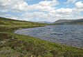
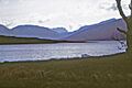
Looking west over Loch a' Bhraoin.
-
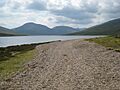
Heading north east along the shore of this loch.
-
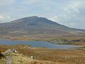
Loch a' Bhraoin With Slioch poking out behind Beinn Bheag in the distance.
-
With the Fisherfield hills in the distance.
-
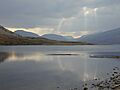
Looking up the loch from near its outflow. The furthest mountain is Slioch, the one on the right overtopping the nearer shoulder is the Fisherfield Munro Mullach Coire Mhic Fhearchair
-
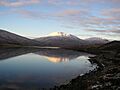
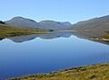
Groban, reflected in Loch a' Bhraoin
-
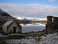
Ruin and Boathouse on Loch a' Bhraoin. This is the second time I have been here when the loch was flat calm.
-
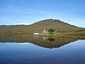
Groban and Beinn Bheag, reflected in Loch a' Bhraoin from the boathouse near the road.
-
The east end of Loch a' Bhraoin. Taken from the path which follows the Allt Breabaig. Meall an t-Sithe is the good looking hill in the distance. For a similar view but taken 6 months later in Autumn
-
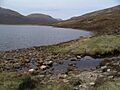
One of the many fords across the small burns feeding the N side of Loch a'Braoin, on the track to Lochivraon. The most distant peak in view, with some snow, is Slioch.


.jpg)


