
Lofa County facts for kids
Quick facts for kids
Lofa County
|
||
|---|---|---|
|
County
|
||
|
||
| Nickname(s):
Tambah Nyumah
|
||

Location in Liberia
|
||
| Country | ||
| Capital | Voinjama | |
| Districts | 6 | |
| Established | 1964 | |
| Area | ||
| • Total | 9,982 km2 (3,854 sq mi) | |
| Population
(2008)
|
||
| • Total | 270,114 | |
| • Density | 27.1/km2 (70/sq mi) | |
| Time zone | UTC+0 (GMT) | |

Lofa County is an important county located in the country of Liberia. It is found in the northwestern part of Liberia.
This county shares its borders with several other places. To the south, it is next to Bong County. To the west, you will find Gbarpolu County. Lofa County also borders two other countries. Its northwestern side touches the nation of Sierra Leone. The northeastern part of Lofa County borders Guinea.
Lofa County is also home to a very special landmark. Mount Wuteve, which is the highest mountain in all of Liberia, is located right here in Lofa County.
Images for kids
-
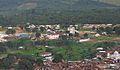
A view of Voinjama, the capital city of Lofa County.

See also
 In Spanish: Condado de Lofa para niños

All content from Kiddle encyclopedia articles (including the article images and facts) can be freely used under Attribution-ShareAlike license, unless stated otherwise. Cite this article:
Lofa County Facts for Kids. Kiddle Encyclopedia.