Lualaba Province facts for kids
Quick facts for kids
Lualaba Province
|
|
|---|---|
|
Province
|
|
 |
|
| Country | |
| Capital | Kolwezi |
| Largest city | Kolwezi |
| Area | |
| • Total | 121,308 km2 (46,837 sq mi) |
| Population
(2006 est.)
|
|
| • Total | 1,677,288 |
| • Density | 13.82669/km2 (35.81096/sq mi) |
| Official language | French |
| National language | Kiswahili |
| Website | http://www.lualaba.gouv.cd/ |
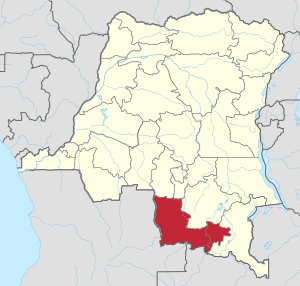
Lualaba is one of the 26 provinces in the Democratic Republic of the Congo. A province is like a large region or state within a country. Its main city and capital is Kolwezi.
Lualaba Province was created in 2015. Before that, it was part of a bigger area called the Katanga Province. This change helped organize the country better.
Contents
Discover Lualaba Province
Lualaba Province is located in the southern part of the Democratic Republic of the Congo. It is a large area, covering about 121,308 square kilometers. That's a lot of land!
What is the Capital City?
The capital city of Lualaba Province is Kolwezi. This city is important because it's where the government of the province is located. It is also the largest city in Lualaba.
How Many People Live Here?
In 2006, about 1,677,288 people lived in Lualaba Province. This number has likely grown since then. People from Lualaba speak different languages.
What Languages Are Spoken?
The official language of Lualaba Province is French. This is the language used in schools and for government business. Another important language spoken by many people is Kiswahili.
Territories of Lualaba
Lualaba Province is divided into smaller areas called territories. These territories help manage the different parts of the province.
Exploring the Territories
The province includes these territories:
- Dilolo
- Kapanga
- Sandoa
- Lubudi
- Mutshatsa
Each territory has its own unique features and communities. They are all important parts of Lualaba Province.
See also
 In Spanish: Provincia de Lualaba para niños
 | Bayard Rustin |
 | Jeannette Carter |
 | Jeremiah A. Brown |

