
Lubusz Voivodeship facts for kids
Quick facts for kids
Lubusz Voivodeship
Województwo lubuskie
|
|||
|---|---|---|---|
|
|||
.png)
Location within Poland
|
|||
_-_PL.svg)
Division into counties
|
|||
| Country | |||
| Seats |
|
||
| Area | |||
| • Total | 13,987.93 km2 (5,400.77 sq mi) | ||
| Population | |||
| • Total | 1,013,031 | ||
| • Density | 72.42180/km2 (187.57159/sq mi) | ||
| • Urban | 657,844 | ||
| • Rural | 355,187 | ||
| ISO 3166 code | PL-08 | ||
| Vehicle registration | F | ||
| Website | lubuskie.pl | ||


Lubusz Voivodeship is a special region, or province, located in western Poland. It's a bit unique because it has two main cities that share the role of its capital. These cities are Gorzów Wielkopolski and Zielona Góra.
This region was created on January 1, 1999. It was formed by combining two older provinces: the former Gorzów Wielkopolski and Zielona Góra Voivodeship.
How Lubusz Voivodeship is Organized
Lubusz Voivodeship is divided into smaller areas called counties, or powiats. There are 14 of these counties in total. Two of them are city counties, meaning they are large cities that act as their own county. The other 12 are land counties, which include smaller towns and rural areas.
These counties are then further divided into 83 even smaller local areas called gminas. Think of gminas as local districts or municipalities. This system helps manage the region effectively.
The two main city counties are Zielona Góra and Gorzów Wielkopolski. They are important centers for the region.
Images for kids
-
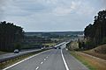
A2 autostrada with view towards west in the Voivodeship
-
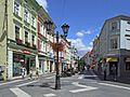
Zielona Góra is the seat of the provincial assembly
-
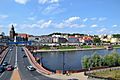
Gorzów Wielkopolski is the seat of the voivodeship governor
-
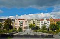
Nowa Sól is part of historic Lower Silesia
-
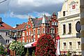
Świebodzin
-
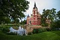
The Muskau Park is a UNESCO World Heritage Site
-
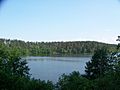
Drawa National Park
-
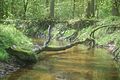
Potok Sucha, protected Nature and Landscape Complex in the Szprotawa Commune


.jpg)


.jpg)
See also
 In Spanish: Voivodato de Lubusz para niños
