Mākaro / Ward Island facts for kids
|
Mākaro (Māori)
|
|
|---|---|
|
Mākaro / Ward Island (Wellington, New Zealand)
|
|
| Geography | |
| Location | Wellington Harbour |
| Coordinates | 41°17′38″S 174°52′17″E / 41.293849°S 174.871514°E |
| Length | 250 m (820 ft) |
| Width | 80 m (260 ft) |
| Highest elevation | 20 m (70 ft) |
| Administration | |
|
New Zealand
|
|
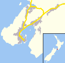
Mākaro/Ward Island is one of three small islands in Wellington Harbour, New Zealand. It sits at the southern end of the North Island. This island is on the eastern side of the harbour, about 1.7 kilometers (1.1 miles) west of the town of Eastbourne. Mākaro/Ward Island is about 250 meters (270 yards) long and 80 meters (87 yards) wide. It is much smaller than Matiu/Somes Island, which is about 5 kilometers (3.1 miles) to the northwest.
Contents
Island Name and History
The Māori name for the island is Mākaro. Māori stories say that Kupe, a famous navigator, named this island and Matiu/Somes Island. He supposedly named them after his daughters or nieces when he first entered the harbour about 1000 years ago. However, there is no way to prove this story.
Island Shape and Surroundings
Mākaro/Ward Island is mostly a steep block of yellowish-brown rock called argillite. It has a fairly flat top. There is a beach made of greywacke stones along the east side of the island. The rest of the coast is rocky. There are two smaller beaches on the western side, with cliffs about 20 meters (66 feet) high behind them. Many small reefs surround the island, especially at its southern end. Large ships use the main shipping channel to Wellington and Seaview ports. This channel passes to the west of Ward Island. The water between Ward Island and Eastbourne is too shallow for big boats.
Island's Past Uses
People have used Mākaro/Ward Island for defense in both ancient and modern times. In the early 1800s, the Ngāti Ira people had a Pā (a fortified village or refuge) on the island. This Pā was not usually lived in. The island's steep cliffs made it a natural refuge.
During the Second World War, a long wooden barrier was built. It stretched 1.8 kilometers (1.1 miles) from Robinson Bay to the island's eastern shore. This barrier helped stop enemy submarines. Also, a net hung from buoys went from the island's western side to Kau Point on the other side of the harbour. Today, you can only see a few concrete blocks on the western side of the island from these old structures.
Fun Activities at the Island
Mākaro/Ward Island is a popular spot for people who enjoy being on the water. Many people visit the island in boats, kayaks, or other watercraft. The reefs and rocky coast are great for fishing and snorkelling. At the southern end of the island, there are beds of seaweed. These provide shelter for many fish. You can also find edible shellfish like Pāua (a type of abalone) and green-lipped mussels there.
Makaro Street in Eastbourne is named after the island. You can see the island from the end of this short street.
The Island's Ecosystem
Mākaro/Ward Island is a special place. It is a scientific reserve managed by the DOC. This means that certain activities are not allowed there. For example, you cannot camp, light fires, or bring dogs onto the island.
The island is home to many seagulls and other seabirds. These birds build their nests on the island's steep slopes. No people live on the island.
To protect the island's wildlife, the DOC has been working to keep it free of rodents. Since 2005, they have placed bait stations on the island. These stations contain special pellets to prevent rats and mice from living there.
 | Leon Lynch |
 | Milton P. Webster |
 | Ferdinand Smith |


