Eastbourne, New Zealand facts for kids
Quick facts for kids
Eastbourne
Māori: Ōkiwi
|
|
|---|---|
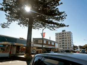
Rimu Street, the main street of Eastbourne
|
|
| Country | New Zealand |
| Region | Wellington Region |
| Territorial authority | Lower Hutt |
| Ward | Harbour |
| Community board | Eastbourne Community Board |
| Electorates |
|
| Area | |
| • Total | 1.93 km2 (0.75 sq mi) |
| Population
(June 2023)
|
|
| • Total | 2,810 |
| • Density | 1,456/km2 (3,771/sq mi) |
Eastbourne (called Ōkiwi in Māori) is a lovely seaside suburb in Lower Hutt, which is part of Wellington, New Zealand. It's a popular spot for people to visit, either by car from Petone or by ferry from central Wellington. Eastbourne is located on the eastern side of Wellington Harbour. It's about five kilometres south of the main Lower Hutt city area. It sits right across the harbour from the Miramar Peninsula in Wellington city. A narrow road along the coast connects it to the rest of Lower Hutt. This road goes through the Eastern Bays and past the industrial area of Seaview. Eastbourne was named after a seaside town in England, also called Eastbourne, which is known for day trips.
The hills around Eastbourne are covered with beautiful native bush and trees. Thanks to a local programme that removes possums, much of the native bush has grown back. This includes the red-flowering northern rātā trees. There are many walking tracks in the bush, including one that runs along the top of the hills. Many early settlers in Eastbourne came from Stromboli, an island near Sicily. Because of this, Eastbourne has an Italian heritage, similar to other parts of Wellington. You can see this especially in the style of some of its buildings.
Contents
Eastbourne's Story: A Look at Its History
Eastbourne has a long history, even before European settlers arrived. Local Māori tribes (called Iwi) had several villages (Kāinga) and fortified settlements (Pā) here for hundreds of years. These settlements were in the bays and on the raised headlands. They were found in bays north of the main suburb, like Point Howard, Lowry Bay, Rona Bay, and Days Bay. These settlements were very important. They helped protect the area from attacks by neighbouring tribes from the Wairarapa, like Ngāti Kahungunu. Raids were common, so local Māori always had to be ready.
European settlement grew after a big earthquake in 1855, called the 1855 Wairarapa earthquake. This earthquake lowered the Waiwhetu river in Seaview. It also raised the shore of Wellington Harbour by two metres. Eastbourne's Italian heritage began in 1892. That's when Italians Bartolo and Italia Russo settled in Rona Bay (which was first called Brown's Bay). They renamed it Russo Bay after themselves. The Russos, who were from Stromboli, opened a hotel. They also started gardening and fishing businesses. They encouraged many of their family and friends to move there too. This helped Eastbourne become a strong little Italian New Zealander community.
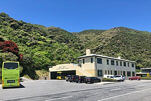
Before it became part of Lower Hutt, Eastbourne was a separate town. It had its own council and local government. The Eastbourne Community Board still exists today. It speaks up for local issues. A local bus station even still has the old "Borough of Eastbourne" name.
The Wahine disaster was New Zealand's worst modern sea accident. It happened on April 10, 1968. The ferry Wahine hit Barrett Reef in Wellington Harbour during a big storm and turned over. There were 734 people on board. Sadly, 53 people died from drowning, injuries, or being exposed to the cold. Eastbourne was cut off from the city because huge waves crashed over Marine Drive. People from the sinking ship started to head towards Eastbourne and Seatoun. Eastbourne residents took in survivors. The two local hairdressing salons gave out all their towels. The local bakery delivered sandwiches, soup, and trays of buns, scones, muffins, pies, and cakes to the RSA (Returned and Services Association). In 2010, a memorial was put up opposite the bus barn. It remembers those who died in the disaster.
People and Population
Eastbourne covers an area of about 1.93 square kilometres. It has an estimated population of 2,810 people as of June 2023, . This means there are about 1456 people living in each square kilometre.
Most people in Eastbourne are of European (Pākehā) background. There are also smaller groups of Māori, Pasifika, and Asian people. Many people in Eastbourne have no religious beliefs. Others are Christian or follow other religions like Hinduism or Buddhism. Many adults in Eastbourne have a university degree.
Fun Things and Features Today
Eastbourne is made up of several smaller bays. These include Point Howard, Sorrento Bay, Whiorau/Lowry Bay, York Bay, Mahina Bay, Sunshine Bay, Days Bay, Rona Bay, Robinson Bay, and Camp Bay.
Eastbourne is known for its relaxed, sunny feel. It has small restaurants and historic homes. Its slightly remote location makes it interesting to other Wellingtonians. People have been coming here for summer day trips since the 1800s.
A regular ferry service connects Eastbourne to Wellington's city centre. The ferry docks at the Days Bay wharf in Eastbourne and at Queen's Wharf in downtown Wellington. This ferry service started in 1886. It became a daily service in 1901. The Eastbourne Borough Council bought it in 1913. The service stopped between 1948 and 1989. Now, East by West Ferries owns and runs the service.
The southern end of the bus route in Eastbourne is at the Bus Barn. This building, officially called the Eastbourne Borough Council Omnibus Service Garage, opened on May 24, 1939. It is a Historic Place Category 2 building. It was in the news in March 2022 when a double-deck bus tried to enter its low doorway!
Eastbourne has two primary schools that are currently open: Muritai School and Wellesley College (which is in Days Bay).
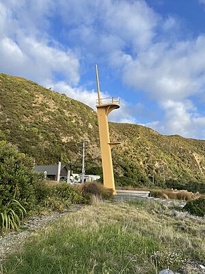
At the very end of Eastbourne, past Burdan's Gate, there's a coastal road only for walkers and cyclists. This road goes out to the entrance of Wellington Harbour. Here, you can see three lighthouses. These include the upper and lower Pencarrow Head Lighthouses, which are no longer used. They were replaced in 1935 by the Baring Head Lighthouse. This area is popular with cyclists and gives access to East Harbour Regional Park.
The hills around Eastbourne are very important for local wildlife. They are home to some of New Zealand's rarest and most endangered plants.
The banded dotterel (tūturiwhatu) is a bird that is nationally vulnerable. It nests on the Eastbourne foreshore (Robinson Bay), Baring Head, and Parangarahu Lakes. Predator Free NZ says that the banded dotterel is more endangered than the whio (blue duck) and the great spotted kiwi. Several groups, including MIRO, Greater Wellington, Hutt City Council, and Taranaki Whānui ki Te Upoko o Te Ika, have been working together since 2013 to protect these coastal-breeding birds.
The Eastbourne banded dotterel colony is the only place this bird breeds inside Wellington Harbour. In 2020, volunteers watching the site noticed that a single cat had eaten eggs and killed chicks. This destroyed seven nests in just one season.
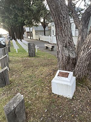
Eastbourne has two ANZAC war memorials. One is along the fence of Muritai School and was put there in 1986. The second is a Pōhutukawa tree. It was planted on July 14, 1915, by Eastbourne Mayor J P Kelly. This tree and its plaque form the first ANZAC memorial ever put up in New Zealand.
Learning in Eastbourne: Schools and Education
Eastbourne has several places for children to learn.
Current Schools
- Muritai School is a primary school for both boys and girls, from Year 1 to Year 8. It has a roll of 358 students as of February 2024.
- Wellesley College is a private primary school just for boys, from Year 1 to Year 8. It had 350 students in May 2014.
- East Harbour Kindergarten is a community kindergarten for children aged 2 to 5 years.
- Barnardos Early Learning Centre Eastbourne is for children aged 0 to 6 years.
- Days Bay Playcentre is a community playcentre for children aged 0–5 years.
- Point Howard Playcentre is a community playcentre for children aged 0–5 years.
Past Schools
- Gollans Valley School was a school in Gollans Valley that closed in 1898.
- Eastbourne nursery playcentre was open around 1943.
- San Antonio School was a Catholic primary school for both boys and girls, from Year 1 to Year 8. It closed in 2022.
Famous People from Eastbourne
Eastbourne has been home to some notable people:
- Chris Bishop (born 1983) is currently a Minister of Housing in New Zealand.
- Ashley Bloomfield (born 1966) is a well-known New Zealand public health official.
- Ted Nightingale was an Eastbourne builder and the founder of the paint company Resene.
- Margaret Magill (1888–1962) was a teacher and school principal. She also served as the deputy mayor of Eastbourne.
- Mimie Wood (1888–1979) was a secretary, accountant, and librarian for the Royal Society of New Zealand. She lived in Eastbourne from 1920.
Past Mayors of Eastbourne
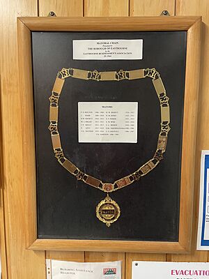
Eastbourne used to have its own mayors before it became part of Lower Hutt. Here are some of them:
- Fred G Bolton, 1906–1909
- John Barr, 1909–1910
- Herbert William Shortt, 1910–1913 and 1924–1925
- W J ORGAN, 1913–1915
- J P Kelly, 1915–1917
- P Levi, 1917–1919
- F H Mather, 1919–1924
- H M Jones, 1925–1931
- S F Fisher, 1931–1933
- Edward Wise, 1933–1950
- Clifford Lyle Bishop, 1950–1980
- Elaine Jakobsson (Mrs), 1980–1986
- C G Bagnall, 1986–1987
- V R Jamieson, 1988–1989
 | Delilah Pierce |
 | Gordon Parks |
 | Augusta Savage |
 | Charles Ethan Porter |


