Magdalena, Intibucá facts for kids
Quick facts for kids
Magdalena
|
|
|---|---|

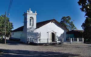
Church in Magdalena
|
|
| Country | Honduras |
| Department | Intibucá |
| Municipality | Magdalena |
| Foundation | 1822 |
| Area | |
| • Total | 41.61 km2 (16.07 sq mi) |
| Elevation | 300 m (1,000 ft) |
| Population
(2015)
|
|
| • Total | 4,422 |
| • Density | 106.273/km2 (275.24/sq mi) |
| Time zone | UTCGMT-6 |
| Postal Code |
14000
|
| Municipality number | 1008 |
Magdalena (Spanish pronunciation: [maɣðaˈlena]) is a small town, also known as a municipality, located in the Intibucá area of Honduras. It is about 86 kilometers (53 miles) south of La Esperanza and 280 kilometers (174 miles) west of Tegucigalpa, the capital city. The municipality of Magdalena includes 7 villages and 33 smaller communities called hamlets.
Contents
People of Magdalena
In 2013, a census counted 4,361 people living in Magdalena. Most of the people, about 65.66%, were Mestizo. This means they have a mix of European and Indigenous (Native American) heritage. About 14.82% were Indigenous, mainly from the Lenca group (14.61%). Around 12.72% were White, and 1.38% were Afro-Honduran or Black. The remaining 5.43% belonged to other groups.
A Look Back: Magdalena's History
It's not fully clear when the first people settled in Magdalena or where they came from. However, we know that nearby Indigenous towns like Camasca and Colomoncagua were already there in the late 1600s.
How Magdalena Started
According to a local historian named Hector P. Nolasco, Magdalena might have started as a group of large farms, or "estates," that were part of the Camasca area. These estates then separated to form their own municipality. Old documents from the early 1700s mention a place called "Hacienda de la Magdalena." This was a large farm that was officially recognized again on July 7, 1740, after a request from Marcos Díaz, an Indigenous Chief from Camasca.
Becoming a Municipality
A notable professor, María Trinidad del Cid, wrote that the municipality of Magdalena was officially founded on October 15, 1821. Her grandfather, Florentín del Cid, worked as the municipal secretary for many years in the late 1800s and early 1900s. Many important historical papers from that time are still available today. However, some documents suggest the municipality might have been founded later, on October 26, 1861.
Magdalena was created from several estates, including La Magdalena, San Blas, La Trinidad, La Caridad, and parts of La Negra Vieja and San Pablo Tenamera. It also included a small village called San Juan Troncoso, which is located near the border with El Salvador, along the Torola River.
Land and Borders
On June 21, 1843, the mayor and chief of the Camasca district helped create the paths and markers that defined Magdalena's borders.
Magdalena was separate from Camasca, but it didn't have enough "common land" for its people to farm freely. Common land is shared land that everyone in a community can use. So, in 1870, the people of Magdalena asked the government to give them some of Camasca's common land to make their territory bigger.
At that time, General José María Medina was the president, and Rosa Muñoz was the governor of the Gracias department, where Magdalena was located. The government sent a land surveyor named Juan Bautista Collart. His job was to measure five "cavalries" (an old unit of land measurement) of Camasca's common land and transfer it to Magdalena. This measurement happened between October 14 and 18, 1870. Today, with modern tools, we know that the municipality measures about 41.46 square kilometers (16 square miles).
See also
 In Spanish: Magdalena (Intibucá) para niños


