Mamoudzou facts for kids
Quick facts for kids
Mamoudzou
|
|
|---|---|
|
Prefecture and commune
|
|
Mamoudzou
|
|
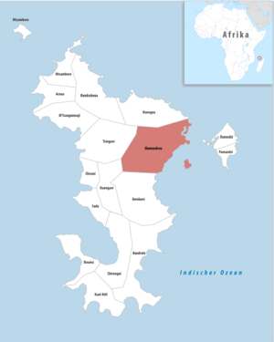
Location of the commune (in red) within Mayotte
|
|
| Country | France |
| Overseas region and department | Mayotte |
| Canton | 3 cantons |
| Intercommunality | CA Dembeni-Mamoudzou |
| Area
1
|
41.94 km2 (16.19 sq mi) |
| Population
(2017)
|
71,437 |
| • Density | 1,703.31/km2 (4,411.6/sq mi) |
| Time zone | UTC+03:00 |
| INSEE/Postal code |
97611 /97600
|
| Elevation | 0–572 m (0–1,877 ft) |
| 1 French Land Register data, which excludes lakes, ponds, glaciers > 1 km2 (0.386 sq mi or 247 acres) and river estuaries. | |
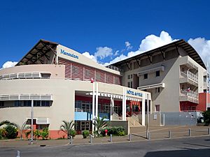
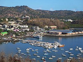
Mamoudzou (pronounced mah-moo-zoo) is the capital city of Mayotte. Mayotte is a French region located far away in the Indian Ocean. Mamoudzou is the largest and most populated town in Mayotte. It is found on Grande-Terre, which is the main island of Mayotte.
The town of Mamoudzou includes six other villages. These are Kawéni, Mtsapéré, Passamainti, Vahibé, Tsoundzou I, and Tsoundzou II. The area is also divided into three smaller districts called cantons. The government runs a radio station in Mamoudzou. It broadcasts in both French and Mahorian languages.
Contents
History of Mamoudzou
The first capital of Mayotte was Dzaoudzi. This town was on a smaller island called Petite-Terre. But in 1977, Mamoudzou was chosen to be the new capital. In 1985, about 12,000 people lived in Mamoudzou.
Over the years, there have been worries about pollution in the ocean near Mamoudzou. Reports show that the water quality in the Coral Reef Lagoon has gotten worse. This is especially true in the strait between Mamoudzou and Dzaoudzi.
What is the Climate Like?
Mamoudzou has a tropical savanna climate. This means it is usually hot all year round. It also has a wet season and a dry season. The average temperature in Mamoudzou is about 27.4 degrees Celsius.
The town gets about 1342 millimeters of rain each year. January is usually the wettest month. April is the warmest month, with temperatures around 28.7 degrees Celsius. August is the coolest month, with temperatures around 25.8 degrees Celsius. The hottest temperature ever recorded was 34.8 degrees Celsius in April 2010. The coldest was 9.5 degrees Celsius in July 1999.
| Climate data for Mamoudzou (1991–2020 averages, extremes 1999−present) | |||||||||||||
|---|---|---|---|---|---|---|---|---|---|---|---|---|---|
| Month | Jan | Feb | Mar | Apr | May | Jun | Jul | Aug | Sep | Oct | Nov | Dec | Year |
| Record high °C (°F) | 34.5 (94.1) |
34.2 (93.6) |
34.7 (94.5) |
34.8 (94.6) |
34.7 (94.5) |
33.2 (91.8) |
32.3 (90.1) |
32.2 (90.0) |
33.8 (92.8) |
33.4 (92.1) |
33.8 (92.8) |
34.0 (93.2) |
34.8 (94.6) |
| Mean daily maximum °C (°F) | 30.9 (87.6) |
31.2 (88.2) |
31.9 (89.4) |
32.3 (90.1) |
31.4 (88.5) |
30.1 (86.2) |
29.3 (84.7) |
29.6 (85.3) |
30.1 (86.2) |
30.7 (87.3) |
30.9 (87.6) |
31.1 (88.0) |
30.8 (87.4) |
| Daily mean °C (°F) | 27.9 (82.2) |
28.1 (82.6) |
28.5 (83.3) |
28.7 (83.7) |
28.0 (82.4) |
26.8 (80.2) |
25.9 (78.6) |
25.8 (78.4) |
26.2 (79.2) |
27.0 (80.6) |
27.6 (81.7) |
28.0 (82.4) |
27.4 (81.3) |
| Mean daily minimum °C (°F) | 25.0 (77.0) |
25.0 (77.0) |
25.1 (77.2) |
25.1 (77.2) |
24.6 (76.3) |
23.5 (74.3) |
22.4 (72.3) |
22.0 (71.6) |
22.3 (72.1) |
23.3 (73.9) |
24.3 (75.7) |
24.9 (76.8) |
24.0 (75.2) |
| Record low °C (°F) | 21.6 (70.9) |
22.0 (71.6) |
21.5 (70.7) |
22.0 (71.6) |
21.7 (71.1) |
20.5 (68.9) |
18.5 (65.3) |
19.5 (67.1) |
19.8 (67.6) |
18.6 (65.5) |
21.8 (71.2) |
22.0 (71.6) |
18.5 (65.3) |
| Average precipitation mm (inches) | 315.1 (12.41) |
257.3 (10.13) |
251.9 (9.92) |
86.5 (3.41) |
40.6 (1.60) |
22.2 (0.87) |
11.8 (0.46) |
15.6 (0.61) |
23.4 (0.92) |
49.9 (1.96) |
97.2 (3.83) |
170.9 (6.73) |
1,342.4 (52.85) |
| Average precipitation days (≥ 1.0 mm) | 16.5 | 14.4 | 14.5 | 7.5 | 4.0 | 3.0 | 2.5 | 2.5 | 3.1 | 4.9 | 7.8 | 12.1 | 92.8 |
| Source: Météo-France | |||||||||||||
How is Mamoudzou Governed?
Mamoudzou is made up of its main town and six other villages. These villages are Kawéni, Mtsapéré, Passamainti, Vahibé, Tsoundzou I, and Tsoundzou II. The town is also divided into three smaller areas called cantons. These are Mamoudzou-1, Mamoudzou-2, and Mamoudzou-3.
Many government offices are located in Mamoudzou. These include departments for education, health, and public works. They have been in the town since before it became the capital. France Télécom, a large phone company, also operates here.
Population Growth
Mamoudzou has grown a lot over the years. In 1966, only 4,556 people lived there. By 2017, the population had grown to 71,437 people. This makes it the most populated town in Mayotte.
| Historical population | ||
|---|---|---|
| Year | Pop. | ±% p.a. |
| 1966 | 4,556 | — |
| 1978 | 7,798 | +4.58% |
| 1985 | 12,026 | +6.38% |
| 1991 | 20,307 | +9.12% |
| 1997 | 32,733 | +8.28% |
| 2002 | 45,485 | +6.80% |
| 2007 | 53,122 | +3.15% |
| 2012 | 57,281 | +1.52% |
| 2017 | 71,437 | +4.52% |
| Source: SPLAF (1966-2007) and INSEE (2012-2017) | ||
Here is a table showing the population of Mamoudzou's villages:
| Village | 1997 | 2002 | |||
|---|---|---|---|---|---|
| Kavani | 3 948 | 5 488 | |||
| Kaweni | 6 206 | 9 604 | |||
| Mamoudzou | 5 666 | 6 533 | |||
| Mtsapéré | 6 979 | 10 495 | |||
| Passamainty | 5 173 | 6 008 | |||
| Tsountsou 1 | 2 093 | 3 058 | |||
| Tsountsou 2 | 574 | 1 063 | |||
| Vahibé | 2 135 | 3 236 | |||
| Statistics accurate as of 1997 | |||||
What is the Economy Like?
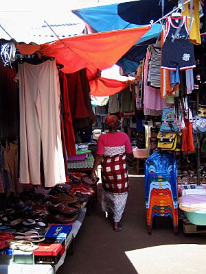
Mamoudzou is an important place for business in Mayotte. It has banks and a shopping center. The main business area is called Place du Marché. Here you can find offices for Air France and Ewa Air, which are airlines. There is also a tourist office.
The magazine Jana na Leo has its main office in Mamoudzou. This magazine writes about life on the island of Mahore. You can also find several restaurants in Mamoudzou, like Les Terrasses and Le Barfly.
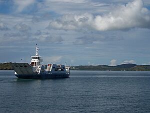
A ferry service connects Mamoudzou to the island of Petite Terre. This ferry is popular with tourists and locals.
Famous People from Mamoudzou
- Manou Mansour (born 1980), a French poet.
Places of Worship
- Our Lady of Fatima Church, Mamoudzou
See also
 In Spanish: Mamoudzou para niños
 | Jewel Prestage |
 | Ella Baker |
 | Fannie Lou Hamer |


