Mapiripán facts for kids
Mapiripán is a town and municipality located in the Meta Department of Colombia. It is known for its natural beauty and its important location within the country.
Quick facts for kids
Mapiripán
|
||
|---|---|---|
|
Municipality and town
|
||
|
||

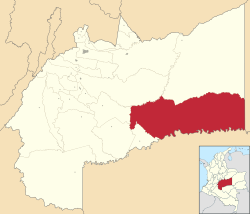
Location of the municipality and town of Mapiripán in the Meta Department of Colombia.
|
||
| Country | ||
| Department | Meta Department | |
| Area | ||
| • Total | 11,900 km2 (4,600 sq mi) | |
| Elevation | 250 m (820 ft) | |
| Population
(Census 2018)
|
||
| • Total | 6,036 | |
| • Density | 0.5072/km2 (1.314/sq mi) | |
| Time zone | UTC-5 (Colombia Standard Time) | |
| Climate | Am | |
Contents
Where is Mapiripán?
Mapiripán is located in the southeastern part of the Meta Department in Colombia. It is part of a large region known for its vast plains and rivers. The town sits at an elevation of about 250 meters (820 feet) above sea level.
How Big is Mapiripán?
The municipality of Mapiripán covers a large area of about 11,900 square kilometers (4,595 square miles). This makes it one of the bigger municipalities in terms of land size in the Meta Department.
People of Mapiripán
According to the 2018 census, Mapiripán has a population of 6,036 people. The community here is made up of different groups, including indigenous people and settlers from other parts of Colombia.
What is the Climate Like?
Mapiripán experiences a tropical monsoon climate, often shortened to "Am" in climate classifications. This means the area has high temperatures all year round. It also has a distinct wet season and a drier season. The wet season brings a lot of rain, which helps the local plants and animals thrive.
Local Government
As a municipality, Mapiripán has its own local government. This government is responsible for managing public services, planning for the town's future, and representing the needs of its citizens. The mayor and local council work together to make decisions for the community.
See also
 In Spanish: Mapiripán para niños
 | Jessica Watkins |
 | Robert Henry Lawrence Jr. |
 | Mae Jemison |
 | Sian Proctor |
 | Guion Bluford |


