Maskinongé River facts for kids
Quick facts for kids Maskinongé River |
|
|---|---|

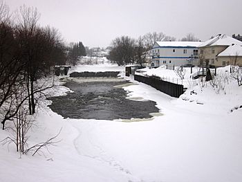
Maskinongé River at Maskinongé, Quebec
|
|
| Other name(s) | "Rivière Maskinongé" (in French) |
| Country | Canada |
| Province | Quebec |
| Region | Mauricie |
| Physical characteristics | |
| Main source | Lake Maskinongé Saint-Gabriel-de-Brandon, Lanaudière, Quebec, Canada 142 m (466 ft) 46°19′16″N 72°21′42″W / 46.32111°N 72.36167°W |
| River mouth | Lake Saint-Pierre Maskinongé, Mauricie, Quebec, Canada 3 m (9.8 ft) 46°09′48″N 73°01′06″W / 46.16333°N 73.01833°W |
| Basin features | |
| Tributaries |
|
The Maskinongé River is a beautiful river in Quebec, Canada. It flows through the Lanaudière and Mauricie regions. This river is about 40 kilometers (25 miles) long.
The Maskinongé River starts at Lake Maskinongé in Saint-Gabriel-de-Brandon. It then flows through several towns. These include Saint-Gabriel-de-Brandon, Saint-Gabriel, and Saint-Didace in Lanaudière. It also passes through Saint-Justin, Louiseville, and Maskinongé. Finally, it empties into the northern part of Lake Saint-Pierre.
Contents
What's in a Name? The Meaning of Maskinongé
The name of the Maskinongé River comes from a type of fish. This fish is called the muskellunge (Esox masquinongy). It is a large fish that looks like a pike.
The word "Maskinongé" comes from the Algonquin language. It means "deformed pike." This name likely describes the unique look of the muskellunge fish.
Exploring the River's Path: Geography
How the River Flows: Course
The Maskinongé River begins its journey at Lake Maskinongé. Here, the water is about 142 meters (466 feet) above sea level. The river then flows southeast for about 52 kilometers (32 miles). It eventually reaches the St. Lawrence River at Maskinongé. At this point, the river is only about 3 meters (10 feet) above sea level.
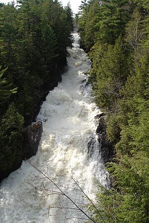
The river has two main waterfalls. The Lauzon Falls drop about 30 meters (98 feet). The Saint-Ursula Falls are even bigger, with a drop of 70 meters (230 feet). These waterfalls show how the river's path changes in elevation.
The Land Beneath: Geology
The area upstream from the Sainte-Ursule Falls is part of the Laurentides. This is a section of the Canadian Shield. The Canadian Shield is a very old part of the Earth's crust. It formed about a billion years ago. Scientists believe it was once as tall as the Himalayas mountains. Over a very long time, erosion slowly wore it down to its current level.
The area downstream from the falls is part of the St. Lawrence Platform. This region has different types of rocks and landforms.
People Living by the River: Population
In 2006, about 14,000 people lived in the Maskinongé River basin. A basin is the area of land that drains into a river. The biggest town in this area is Saint-Gabriel. This town is located right on the shore of Lac Maskinongé.
Wildlife Along the Maskinongé River: Natural Environment
Fish and Birds
The Maskinongé River is home to many different kinds of fish. There are 52 species of fish found here. Some of the popular fish for sport fishing include:
- Brook trout (Salvelinus fontinalis)
- Lake trout (Salvelinus namaycush)
- Muskellunge (Esox masquinongy)
Other fish species found in the river include:
- Redhorse sucker (Moxostoma macrolepidotum)
- Rock bass (Ambloplites rupestris)
- Brown trout (Salmo trutta)
- Creek chub (Semotilus corporalis)
- Yellow perch (Perca flavescens)
- Horned dace (Semotilus atromaculatus)
- White sucker (Catostomus commersonii)
- Brown bullhead (Ameiurus nebulosus)
Many different kinds of birds also visit the river basin. They use the river and its surroundings for food and shelter.
A Look Back in Time: History
The Maskinongé River has a rich history. The Attikameks, an Indigenous people, used the river long ago. They traveled along it to get from Matawinie to Trois-Rivières. The river was an important route for them.
Around the year 1700, French settlers began to arrive. They started to build communities in the area of Maskinongé. Later, in 1818, the first settlers came to live near Lake Maskinongé.
In the late 1800s, a private club called the Mastigouche club was formed. This club was for hunting and fishing in the northern part of the river basin. In the 1970s, the government took over the club's land. This area then became part of the Mastigouche Wildlife Reserve and the Nymphs' Nest. These areas help protect the natural environment and wildlife.
 | George Robert Carruthers |
 | Patricia Bath |
 | Jan Ernst Matzeliger |
 | Alexander Miles |


