Melmore, Ohio facts for kids
Quick facts for kids
Melmore, Ohio
|
|
|---|---|

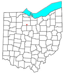
Location of Melmore, Ohio
|
|
| Country | United States |
| State | Ohio |
| County | Seneca |
| Township | Eden |
| Area | |
| • Total | 0.59 sq mi (1.54 km2) |
| • Land | 0.59 sq mi (1.54 km2) |
| • Water | 0 sq mi (0.00 km2) |
| Elevation | 856 ft (261 m) |
| Population
(2020)
|
|
| • Total | 173 |
| • Density | 290.7/sq mi (112.23/km2) |
| Time zone | UTC-5 (Eastern (EST)) |
| • Summer (DST) | UTC-4 (EDT) |
| ZIP codes |
44845
|
| FIPS code | 39-48972 |
| GNIS feature ID | 2628931 |
Melmore is a small community located in Seneca County, Ohio, United States. It is part of Eden Township. Melmore is known as a census-designated place, which means it's an area that the government counts separately for population statistics.
In 2020, the population of Melmore was 173 people. The town has its own post office with the ZIP code 44845. You can find Melmore where two main roads, State Route 67 and State Route 100, cross paths.
Melmore's Story: A Look Back
Melmore was officially planned and mapped out in 1824. This process is called "platting," which means creating a detailed map of a town's streets and lots.
The name Melmore has a sweet origin! It comes from the Latin word mel, which means "honey." This name was chosen because the town is located near a stream called Honey Creek.
A post office was first opened in Melmore in 1825. It served the community for many years, finally closing its doors in 1993.
Who Lives in Melmore?
| Historical population | |||
|---|---|---|---|
| Census | Pop. | %± | |
| 2020 | 173 | — | |
| U.S. Decennial Census | |||
The United States government counts how many people live in different areas every ten years. This count is called a census. The most recent census in 2020 showed that 173 people lived in Melmore.
See also
 In Spanish: Melmore (Ohio) para niños

