- This page was last modified on 17 October 2025, at 10:18. Suggest an edit.
Memphis & Arkansas Bridge facts for kids
| Memphis & Arkansas Bridge | |
|---|---|

Memphis & Arkansas Bridge
|
|
| Coordinates | 35°7′39.02″N 90°4′32.42″W / 35.1275056°N 90.0756722°W |
| Carries | 4 lanes of |
| Crosses | Mississippi River |
| Locale | West Memphis, Arkansas and Memphis, Tennessee |
| Official name | Memphis & Arkansas Bridge |
| ID number | 79I00550101 |
| Characteristics | |
| Design | Cantilevered through truss bridge |
| Total length | 5,222 feet (1,592 m) |
| Width | 52 feet (16 m) |
| Longest span | 770 feet (235 m) |
| Clearance below | 112 feet (34 m) |
| History | |
| Opened | December 17, 1949 |
| Statistics | |
| Daily traffic | 62,355 (2016) |
|
Memphis & Arkansas Bridge
|
|
| Lua error in Module:Location_map at line 420: attempt to index field 'wikibase' (a nil value). | |
| Location | Memphis, TN |
| Built | 1949 |
| NRHP reference No. | 01000139 |
| Added to NRHP | February 16, 2001 |
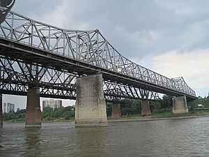
The Memphis & Arkansas Bridge is a big bridge that crosses the Mississippi River. It connects West Memphis, Arkansas and Memphis, Tennessee. People in Memphis often call it the "Old Bridge." This helps them tell it apart from the "New Bridge," which is the Hernando de Soto Bridge.
This bridge is a special type called a cantilevered through truss bridge. It carries a major highway, Interstate 55, and several U.S. Routes. These include U.S. Route 61, U.S. Route 64, U.S. Route 70, and U.S. Route 79. It also carries the start of Tennessee State Route 1.
Building the Memphis & Arkansas Bridge
The Memphis & Arkansas Bridge was finished in 1949. It is made up of five large sections called Warren through trusses. Each of these sections is about 790 feet long. The total length of the bridge, including its approach parts, is about 5,222 feet.
This bridge is unique because it was the only bridge built before 1950 over the Mississippi River that was only for cars and trucks. It was designed by a company called Modjeski and Masters. This company also helped design the Harahan Bridge, which was built earlier in 1916. The Harahan Bridge carries both cars and trains. In 2001, the Memphis & Arkansas Bridge was added to the National Register of Historic Places. This means it is an important historical site.
Bridge Design and Changes
When the bridge was built, the Interstate Highway System did not exist yet. This means the bridge was not built to the same standards as today's highways. For example, it did not have a concrete barrier between cars going in different directions. This barrier was added later to make it safer.
The bridge also had sidewalks on both sides for people to walk on. These sidewalks were outside the main steel structure. Today, these sidewalks are also separated from the traffic lanes by concrete barriers. On the Tennessee side, you can reach the sidewalks from the city. But on the Arkansas side, the sidewalks end in grassy areas near the highway.
Using the Bridge for Walking or Biking
The sidewalk on the Memphis & Arkansas Bridge is part of the Mississippi River Trail. However, it is not safe to walk or bike across this bridge. It is an Interstate Highway, and using the vehicle lanes for walking or biking is against the rules.
In 2012, a person riding a bike was hit by a car near the bridge. This showed how dangerous it was. Luckily, in 2016, a new path for walkers and bikers opened on the nearby Harahan Bridge. This new path made it much safer to cross the river without using the busy I-55 bridge.
