Merrydale, Louisiana facts for kids
Quick facts for kids
Merrydale, Louisiana
|
|
|---|---|

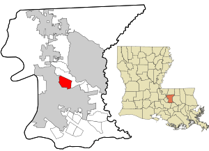
Location in East Baton Rouge Parish and the state of Louisiana.
|
|
| Country | United States |
| State | Louisiana |
| Parish | East Baton Rouge |
| Area | |
| • Total | 4.24 sq mi (10.99 km2) |
| • Land | 4.24 sq mi (10.99 km2) |
| • Water | 0.00 sq mi (0.00 km2) |
| Elevation | 52 ft (16 m) |
| Population
(2020)
|
|
| • Total | 9,227 |
| • Density | 2,174.64/sq mi (839.56/km2) |
| Time zone | UTC-6 (CST) |
| • Summer (DST) | UTC-5 (CDT) |
| Area code(s) | 225 |
| FIPS code | 22-49940 |
Merrydale is a community in East Baton Rouge Parish, Louisiana, United States. It is known as a census-designated place (CDP). This means it is a place that the government counts for population, but it is not officially a city or town.
In 2020, about 9,227 people lived in Merrydale. It is part of the larger Baton Rouge area. This area is called a Metropolitan Statistical Area because it includes a big city and its surrounding communities.
Where is Merrydale?
Merrydale is located in the middle of East Baton Rouge Parish. It is found at coordinates 30°30′15″N 91°6′58″W / 30.50417°N 91.11611°W. The community shares borders with Baton Rouge to its south and west.
Two important roads run near Merrydale. U.S. Route 190, also known as the Airline Highway, is along its southwest edge. Louisiana Highway 37 (Greenwell Springs Road) is part of its southern border. Downtown Baton Rouge is about 7 miles (11 km) to the southwest.
The United States Census Bureau says that Merrydale covers a total area of about 4.2 square miles (11.0 square kilometers). All of this area is land.
Who Lives in Merrydale?
The number of people living in Merrydale has changed over the years.
| Historical population | |||
|---|---|---|---|
| Census | Pop. | %± | |
| 1990 | 10,395 | — | |
| 2000 | 10,427 | 0.3% | |
| 2010 | 9,772 | −6.3% | |
| 2020 | 9,227 | −5.6% | |
| sources: | |||
Here is a look at the different groups of people living in Merrydale as of 2020:
| Group | Number | Percentage |
|---|---|---|
| White (not Hispanic) | 233 | 2.53% |
| Black or African American (not Hispanic) | 8,566 | 92.84% |
| Native American | 11 | 0.12% |
| Asian | 3 | 0.03% |
| Pacific Islander | 5 | 0.05% |
| Other/Mixed | 148 | 1.6% |
| Hispanic or Latino | 261 | 2.83% |
In 2020, there were 9,227 people living in Merrydale. These people lived in 2,901 households. A household can be a family or a group of unrelated people living together. There were also 2,026 families.
In 2000, there were 10,427 people. About 47.3% of households had children under 18. The average household had about 3 people. The average family had about 3.5 people.
The population was spread out by age. About 34.6% of people were under 18 years old. About 6.8% were 65 years or older. The average age was 29 years old.
Schools in Merrydale
The East Baton Rouge Parish Public Schools system is in charge of education in Merrydale.
There are three elementary schools that serve different parts of Merrydale:
- Merrydale Elementary School serves the central area.
- Glen Oaks Park Elementary serves the northern area.
- Celerity Lanier Elementary serves the southern area.
As of 2016, Celerity Lanier Elementary was managed by the Recovery School District (RSD). This meant students in that area could also choose to go to Merrydale Elementary, which is directly controlled by East Baton Rouge Parish Schools.
For middle school, students are usually zoned for Glen Oaks Middle School in Baton Rouge. In 2016, this school was also under the RSD. So, students could also attend North Banks Middle School, which is directly managed by East Baton Rouge Parish Schools.
High school students in Merrydale attend Glen Oaks High School, which is located right in Merrydale.
See also
 In Spanish: Merrydale para niños
 | Delilah Pierce |
 | Gordon Parks |
 | Augusta Savage |
 | Charles Ethan Porter |

