Miraflores, Guaviare facts for kids
Quick facts for kids
Miraflores, Guaviare
|
||
|---|---|---|
|
Municipality and town
|
||
|
||

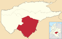
Location of the municipality and town of Miraflores, Guaviare in the Guaviare Department of Colombia.
|
||
| Country | ||
| Department | Guaviare Department | |
| Area | ||
| • Total | 11,709 km2 (4,521 sq mi) | |
| Population
(Census 2018)
|
||
| • Total | 5,007 | |
| • Density | 0.42762/km2 (1.10753/sq mi) | |
| Time zone | UTC-5 (Colombia Standard Time) | |
| Climate | Am | |
Miraflores is a town and a municipality located in the Guaviare Department of Colombia. This area officially became a municipality on February 8, 1990. In 1998, a police base in Miraflores faced a challenge from a rebel group. However, it was rebuilt and reoccupied in February 2004. In 1993, the Guaviare Department had about 14,381 residents.
Contents
Exploring Miraflores: Geography
Miraflores is found at coordinates N 01°22'14" and W 71°57'41". It sits about 180 meters (590 feet) above sea level. The town is approximately 150 kilometers (93 miles) from San Jose del Guaviare, the capital of the Guaviare Department. It is located near the Itilla River and Unilla River.
Land and Climate in Miraflores
The land around Miraflores is mostly flat or gently rolling. It is covered by thick jungle, which is typical of the Amazon basin region. The climate here is warm and very humid. The average temperature stays around 28°C (82°F) throughout the year. The municipality is surrounded by the Vaupés River and many other smaller rivers and streams.
Miraflores Through Time: History
Miraflores was first settled by a group of people who moved into the area during the 20th Century. It officially became a municipality in 1990. This happened when the area, which was then called the Comisaria of Guaviare, became the Guaviare Department.
What Miraflores Produces: Economy
The main legal ways people make a living in Miraflores involve logging and farming. Logging means cutting down trees for wood. Farming includes growing crops. A smaller part of the economy comes from artisan fishing. This means people catch fish using traditional methods, often for their own use or to sell locally.
See also
 In Spanish: Miraflores (Guaviare) para niños
 | John T. Biggers |
 | Thomas Blackshear |
 | Mark Bradford |
 | Beverly Buchanan |


