
National Register of Historic Places listings in Knox County, Tennessee facts for kids
This is a list of special places in Knox County, Tennessee, that are protected because of their history. These places are part of the National Register of Historic Places, which is like a national list of important buildings, sites, and objects in the United States.
In Knox County, there are 115 places on this list, including one very special one called a National Historic Landmark. Some other places were once on the list but have been removed.
A Look Back at Knox County's History

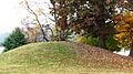
Long ago, the first people living in what is now Knox County were Native Americans. They built large mounds of earth, and some of these are still here today. Later, explorers like Hernando de Soto traveled through the area, but they didn't build lasting homes.
Then, in 1783, the state of North Carolina made land available. This brought early settlers to the region. One important person was General James White. He eventually owned the land where downtown Knoxville is now.
James White first settled in eastern Knox County in 1785. A year later, in 1786, he built a cabin in what became downtown Knoxville. He asked his son-in-law, Charles McClung, to plan out the town. They created 16 blocks with four lots each. Some lots were saved for White's home, a cemetery, and a college. The rest were sold in a lottery in 1791.
By 1792, the community started to grow. Knox County was officially created. Settlers built homes, and the first store and tavern opened. In 1793, soldiers came to protect the new settlers.
The first buildings were simple, meeting basic needs like homes, churches, and inns. Land was also set aside for Blount College, which is now the University of Tennessee.
Knox County grew in two main ways:
- Expanding the town: The original 16 blocks of Knoxville grew. James White's son, Moses White, planned East Knoxville, which was once a separate town.
- Building roads: Roads connected James White's Fort to other parts of the state. The "Knoxville Road" brought settlers from Virginia. By 1795, Kingston Pike connected the fort to the western part of the county. This road later became the "Nashville Road." By 1807, many settlers were passing through Knoxville on their way west. Another important road, "Emory Road," was protected by Adair's Fort. In 1792, the first ferry across the Tennessee River started operating.
Even though Knoxville stopped being Tennessee's capital around 1816, it kept growing slowly. Slavery was not as widespread in East Tennessee as in other parts of the state because of the mountains. However, some plantations existed in the valleys, and a few of their houses are still standing.
Knoxville was somewhat isolated until railroads arrived. Then, because of its central location, the city grew very quickly. The East Tennessee & Virginia Railroad (later part of Southern Railway) and the Louisville and Nashville Railroad both came to Knoxville. This brought two important transportation companies and two impressive train stations. The 1880s were a time of huge growth for the city, and it grew a lot again after World War II.

Many of the buildings now on the National Register of Historic Places show this growth. Some early settlements, like Ramsey House and Marble Springs, were in the countryside. As Kingston Pike developed, fancy homes like Crescent Bend were built in the wealthy western part of Knox County. Kingston Pike also connected smaller communities like Bearden and Farragut to Knoxville.
The late 1800s saw a lot of new businesses and homes. When streetcars started running, neighborhoods expanded north and south. Later, cars allowed even more growth, spreading out from the city center.
Sadly, as the county grew, many old buildings were lost. For example, the 18th-century Chisholm Tavern was torn down in the 1900s. The Mabry Hood House was demolished for a new road. The Baker Peters House survived, but its surroundings changed a lot. Even James White's Fort was moved from its original spot. Because it was moved, the fort cannot be on the National Register. However, preservation groups have rebuilt its old walls and other buildings, making it a great place to visit today.
Current Listings
Knox County has many amazing places on the National Register of Historic Places. These include old homes, churches, schools, and even a unique gas station! Here are a few examples:
- Adair Gardens Historic District: This area has many houses built in the 1920s and 1930s in the Fountain City community.
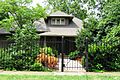
- Airplane Service Station: This gas station was built in 1930 and is shaped like an airplane! It's located near Knoxville in the Powell community.
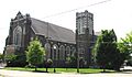
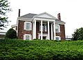
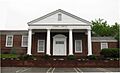
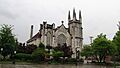
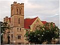
- Asbury Methodist Episcopal Church, South: Now called Asbury United Methodist Church, this historic church is an important part of the community.
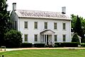
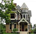
- Alexander Bishop House: This house is believed to have been built way back in the early 1790s.
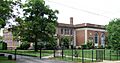
- Ayres Hall: This building is located on the University of Tennessee campus.
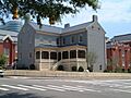
- Bleak House: Also known as "Confederate Memorial Hall," this building is now a museum.
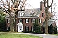
- William Blount Mansion: This is a very important historical site, recognized as a National Historic Landmark.
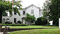
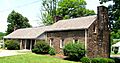
- Boyd-Harvey House: This house is located west of Knoxville near Concord.
- Alfred Buffat Homestead: This homestead was built in the late 1860s in northeast Knoxville.
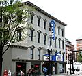
- Burwell Building Tennessee Theater: Built in 1907, this theater has a beautiful Spanish-Moorish design.
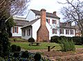
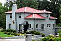
- Camp House: Often called "Greystone," this large house was finished in 1890 and now holds offices for a TV station.
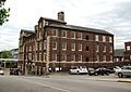
- Candoro Marble Works: This complex, built in 1914, was used for finishing marble. It includes a showroom and garage designed by architect Charles I. Barber.
- Central United Methodist Church: This church was designed in the Gothic Revival style by Baumann & Baumann.
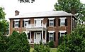
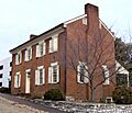
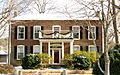
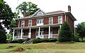
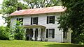
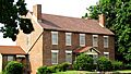
- Chesterfield: This Georgian-style house was built in 1838.
- Christenberry Club Room: This building was designed by a well-known Knoxville architectural firm, Barber & McMurry.
- Church Street Methodist Church: This church was designed by Barber & McMurry and John Russell Pope.
- Concord Village Historic District: This historic area is in the community of Concord.
- Contractor's Supply, Inc.: This building was built in 1947 in the Moderne style.
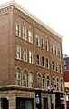
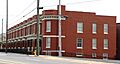
- Cowan, McClung and Company Building: Now called the "Fidelity Building," it was built in 1871.
- Craighead-Jackson House: This historic house is located on State Street.
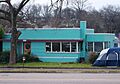
- Daniel House: This unique house was built in the Moderne style using the frame of a Quonset hut.
- Daylight Building: This building is located on Union Avenue.
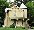
- H.L. Dulin House: Also known as "Crescent Bluff," this house is on Kingston Pike.
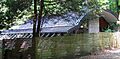
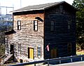
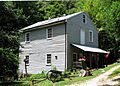
- Ebenezer Mill: This gristmill in West Knoxville is powered by a turbine.
- Emory Place Historic District: This area includes Knoxville High School, a church, a fire station, and many other buildings.
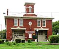
- Fire Station No. 5: This early 20th-century fire station served the Mechanicsville neighborhood.
- First Baptist Church: This church was designed by Dougherty & Gardner.
- First Presbyterian Church Cemetery: This is the oldest cemetery in Knoxville.
- Forest Hills Boulevard Historic District: This district has 20 houses built in the late 1920s and 1930s.
- Fort Sanders Historic District: This area has hundreds of houses and buildings built around 1880-1920, near the Civil War-era Fort Sanders.
- Fourth and Gill Historic District: This district includes three churches and many houses built between 1880 and 1930.
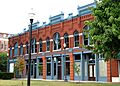
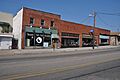
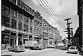
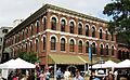
- Gay Street Commercial Historic District: This area has almost three dozen buildings from Knoxville's commercial boom period (1880-1940).
- General Building: Designed by Barber & McMurry, this building is now home to First Bank.
- Gibbs Drive Historic District: This district has several early 20th-century houses in Knoxville's Fountain City community.
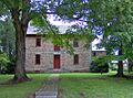
- Nicholas Gibbs House: This log house was built in 1793 by pioneer Nicholas Gibbs.
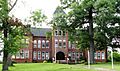
- Giffin Grammar School: This school building is located on Beech Street.
- Happy Holler Historic District: This district is part of a larger plan for Knoxville and Knox County.
- Hilltop: This property is located on Lyons View Pike.
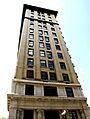
- Holston National Bank: Designed by John Kevan Peebles, this building is now a tall apartment building called "The Holston."
- Hopecote: Designed by local architect John Fanz Staub, this house has unique features like wood from the birthplace of Admiral David Farragut. It's used as a guesthouse by the University of Tennessee.
- Hotpoint Living-Conditioned Home: This "starter home" was built in 1954 as a demonstration house.
- Island Home Park Historic District: This district includes 119 houses built between 1899 and 1940 in the Island Home Park community.
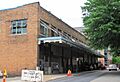
- Jackson Avenue Warehouse District: This area has many historic warehouses.
- Andrew Johnson Hotel: This building now holds offices for Knox County Schools.
- Leroy Keener House: This Greek Revival-style house is in southeast Knox County.
- Kingston Pike Historic District: This district includes several important homes like Crescent Bend and the H.L. Dulin House.
- Knollwood: This property is currently home to Schaad Companies.
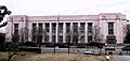
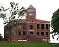
- Knox County Courthouse: This historic courthouse was built by Stephenson and Getaz.
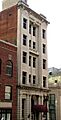
- Knoxville Business College: Often called the "Keyhole Building," it now has apartments.
- Knoxville College Historic District: This district is part of the historic Knoxville College.
- Knoxville Iron Foundry Complex-Nail Factory and Warehouse: Built in 1875, this old nail factory is now an event center called "The Foundry."
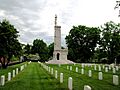
- Knoxville National Cemetery: This is a historic cemetery.
- Knoxville Post Office: This building was designed by Baumann & Baumann.
- Knoxville YMCA Building: This building was designed by Barber & McMurry.
- Lamar House Hotel: Built in 1816, the Bijou Theater was added to it in 1909.
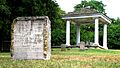
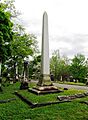
- Lebanon in the Forks Cemetery: This cemetery has the oldest marked burial in Knox County.
- Lincoln Park United Methodist Church: This church is located on Pershing Street.
- Lindbergh Forest Historic District: This was an early neighborhood for cars, developed in the late 1920s and 1930s.
- Louisville and Nashville Freight Depot: This depot was built between 1903 and 1904.
- Louisville and Nashville Passenger Station: Built between 1904 and 1905, this station is now the Knox County STEM Academy.
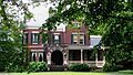
- Joseph Alexander Mabry, Jr. House: Built in 1858, this house is commonly called the Mabry-Hazen House and is now a museum.
- Mall Building: Also known as the Kern Building, it was designed by Joseph Baumann and built in 1875.
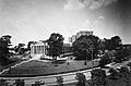
- Marble Springs: This historic site is located south of Knoxville.
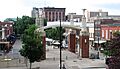
- Market Square Commercial Historic District: This area has 20 buildings built between 1870 and 1925.
- Maxwell-Kirby House: This house is located on Northshore Drive.
- Samuel McCammon House: This house now holds offices for a plumbing company.
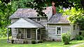
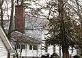
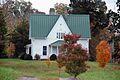
- Alexander McMillan House: This house was built around 1785 by early pioneer Alexander McMillan.
- Mead Marble Quarry: This site includes a marble quarry and a lime plant.
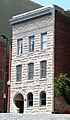
- Mechanics' Bank and Trust Company Building: This building is on Gay Street.
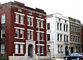
- Mechanicsville Historic District: This district has many houses and buildings built in the late 1800s and early 1900s.
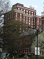
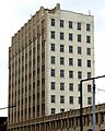
- Medical Arts Building: Built between 1929 and 1930, this was an office building for doctors.
- Middlebrook: This is a frame house from 1845.
- Minvilla: Built in 1913, this complex was later a motel and is now housing for people experiencing homelessness.
- Monday House: Also called the Weigel-Shell House.
- Benjamin Morton House: Built in 1927 for Knoxville mayor Benjamin Morton, it was designed by Baumann & Baumann.
- Murphy Springs Farm: This farm is located on Murphy Road.
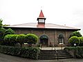
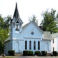
- New Salem United Methodist Church: This Gothic Revival-style church is in South Knox County.
- Capt. James Newman House: This house is located on Newman Lane.
- North Hills Historic District: This district has many houses built in the late 1920s and 1930s.
- Old Gray Cemetery: This is a historic cemetery in Knoxville.
- Old Knoxville City Hall: Originally a school for the deaf, it was used as city hall and is now part of Lincoln Memorial University.
- Old North Knoxville Historic District: This district has almost 500 houses and other buildings built between 1888 and 1940.
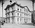
- Old Post Office Building: Usually called the "Old Customs House," it was designed by Alfred B. Mullett and now houses part of the East Tennessee Historical Society.
- Ossoli Circle Clubhouse: This building was designed by Barber & McMurry.
- Park City Historic District: This district has hundreds of houses built in the late 1800s and early 1900s.
- Park City Junior High School: Designed by Albert Baumann, Jr., this school was later turned into apartments.
- James Park House: This house was built in 1812 and now serves as corporate headquarters for Gulf and Ohio Railways.
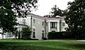
- Peters House: Built in the 1850s, it was remodeled in the 1890s by George Franklin Barber.
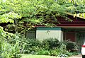
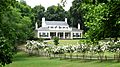
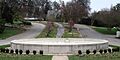
- Ivan Racheff House: This was the home and gardens of Knoxville Iron Company president Ivan Racheff and is now a museum.
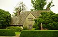
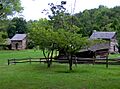
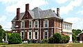
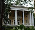
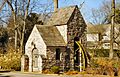
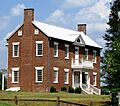
- Ramsey House: This house, built by early Knoxville architect Thomas Hope, is now a museum.
- Riverdale Historic District: This district has several 19th-century houses related to the Riverdale community.
- Riverdale Mill: This 19th-century gristmill still has its original water wheel.
- Riverdale School: This school was built in 1938 and designed by Barber & McMurry.
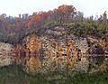
- Ross Marble Quarry: This is a Tennessee marble quarry.
- Avery Russell House: Also known as the Martin-Russell House, located in Farragut.
- St. John's Lutheran Church: This church was designed by R. F. Graf.
- Savage House and Garden: This property features a Japanese-style garden created around 1915 in Fountain City.
- Seven Islands Methodist Church: The church's congregation started in 1802, and the building was constructed in the 1850s.
- South Market Historic District: This district includes several buildings constructed around 1895-1907.
- Southern Terminal and Warehouse Historic District: This historic district includes the Southern Terminal and warehouses.
- Statesview: This house was built by early Knoxville architect Thomas Hope for surveyor Charles McClung.
- Stratford: Built in 1910 by furniture magnate James G. Sterchi, this mansion is now an event center.
- Talahi Improvements: This was a suburban development from the late 1920s in the Sequoyah Hills neighborhood.
- Tennessee School for the Deaf Historic District: This district is part of the Tennessee School for the Deaf.
- Trinity Methodist Episcopal Church: Now called the "Knoxville House of Faith," it is home to a Pentecostal church.
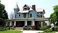
- Gen. Lawrence D. Tyson House: This house was remodeled in 1907 by George Franklin Barber and is now the Tyson Alumni House.
- Tyson Junior High School: Designed by Baumann & Baumann, this school is now an office building.
- U.T. Agriculture Farm Mound: This mound was built around 1000 AD by people from the Late Woodland period.
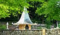
- Westmoreland Water Wheel and Gatepost: Built in 1923, this was designed by Charles I. Barber.
- Westwood: Also known as the Adelia Armstrong Lutz House, it was designed by Baumann Brothers.
- Gen. John T. Wilder House: This house was built in 1904 by General John T. Wilder.
- Col. John Williams House: This was the home of senator and diplomat John Williams.
Former Listings
Some historic places were once on the National Register but have since been removed, often because they were damaged or torn down. Here are a few examples:
- Caswell-Taylor House: This house, once home to Governor Robert Love Taylor, was damaged by fire and then torn down.
- Commerce Avenue Fire Hall: This fire hall was demolished.
- Lebanon-in-the-Fork Presbyterian Church: This was the first Presbyterian church in Knox County, founded in 1791. Its building was destroyed in a fire in 1981, but its cemetery is still listed.
- Thomas J. Walker House: This house burned down in 2003.
- Isaac Ziegler House: This house was demolished.
Images for kids
-
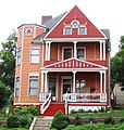
Adair Gardens Historic District
-
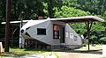
Airplane Service Station
-
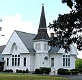
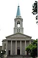
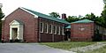
Asbury United Methodist Church
-
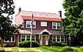
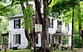
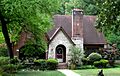
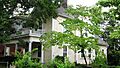
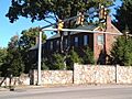
Alexander Bishop House
-
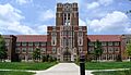
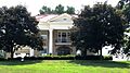
Ayres Hall
-
Bleak House
-
William Blount Mansion
-
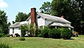
Boyd-Harvey House
-
Alfred Buffat Homestead
-
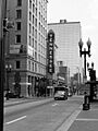
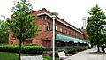
Burwell Building Tennessee Theater
-
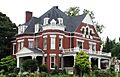
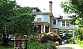
Camp House (Greystone)
-
Candoro Marble Works
-
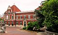
Central United Methodist Church
-

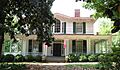
Chesterfield
-
Christenberry Club Room
-
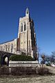
Church Street Methodist Church
-

Concord Village Historic District
-
Contractor's Supply, Inc.
-
Cowan, McClung and Company Building (Fidelity Building)
-
Craighead-Jackson House
-
Daniel House
-
Daylight Building
-
H.L. Dulin House (Crescent Bluff)
-
Ebenezer Mill
-
Emory Place Historic District
-
Fire Station No. 5
-
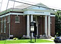
First Baptist Church
-
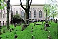
First Presbyterian Church Cemetery
-
Forest Hills Boulevard Historic District
-
Fort Sanders Historic District
-
Fourth and Gill Historic District
-
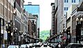
Gay Street Commercial Historic District
-
General Building
-
Gibbs Drive Historic District
-
Nicholas Gibbs House
-
Happy Holler Historic District
-
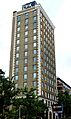
Holston National Bank (The Holston)
-
Hopecote
-
Hotpoint Living-Conditioned Home
-

Island Home Park Historic District
-
Jackson Avenue Warehouse District
-
Andrew Johnson Hotel
-
Leroy Keener House
-
Kingston Pike Historic District
-
Knollwood
-
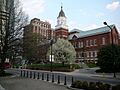
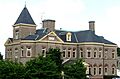
Knox County Courthouse
-
Knoxville Business College (Keyhole Building)
-
Knoxville College Historic District
-
Knoxville Iron Foundry Complex-Nail Factory and Warehouse
-
Knoxville National Cemetery
-
Knoxville Post Office
-
Knoxville YMCA Building
-
Lamar House Hotel (Bijou Theatre)
-
Lebanon in the Forks Cemetery
-
Lincoln Park United Methodist Church
-
Lindbergh Forest Historic District
-
Louisville and Nashville Freight Depot
-
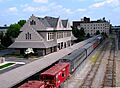
Louisville and Nashville Passenger Station
-
Joseph Alexander Mabry, Jr. House (Mabry-Hazen House)
-
Mall Building
-
Marble Springs
-
Market Square Commercial Historic District
-
Samuel McCammon House
-
Alexander McMillan House
-
Mead Marble Quarry
-
Mechanics' Bank and Trust Company Building
-
Mechanicsville Historic District
-
Medical Arts Building
-
Middlebrook
-
Minvilla
-
Monday House
-
Benjamin Morton House
-
Murphy Springs Farm
-
New Salem United Methodist Church
-
North Hills Historic District
-
Old Gray Cemetery
-
Old Knoxville City Hall
-
Old North Knoxville Historic District
-
Old Post Office Building (Old Customs House)
-
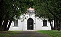
Ossoli Circle Clubhouse
-
Park City Historic District
-
Park City Junior High School
-
James Park House
-
Peters House
-
Ivan Racheff House
-
Ramsey House
-
Riverdale Historic District
-
Riverdale Mill
-
Riverdale School
-
Ross Marble Quarry
-
Avery Russell House
-
St. John's Lutheran Church
-
Savage House and Garden
-
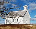
Seven Islands Methodist Church
-
South Market Historic District
-
Southern Terminal and Warehouse Historic District
-
Statesview
-
Stratford
-
Talahi Improvements
-
Tennessee School for the Deaf Historic District
-
Trinity Methodist Episcopal Church (Knoxville House of Faith)
-
Gen. Lawrence D. Tyson House (Tyson Alumni House)
-
Tyson Junior High School
-
U.T. Agriculture Farm Mound
-
Westmoreland Water Wheel and Gatepost
-
Westwood
-
Gen. John T. Wilder House
-
Col. John Williams House
-
Caswell-Taylor House (Former Listing)
-
Commerce Avenue Fire Hall (Former Listing)
-
Isaac Ziegler House (Former Listing)


