
National Register of Historic Places listings in Allen County, Kentucky facts for kids

Imagine a special list of places that are super important because of their history or how they look! That's what the National Register of Historic Places is. It's like a hall of fame for buildings, sites, and objects across the United States. When a place is on this list, it means it's worth protecting and remembering for future generations.
Allen County, Kentucky has many cool places on this list. These spots tell us stories about the past, from old farms to downtown buildings. There are 12 different properties and areas in Allen County that are recognized for their historical value. Let's explore some of these amazing historic sites!
Contents
Exploring Allen County's Historic Places
Allen County is home to several fascinating places that have earned a spot on the National Register of Historic Places. These sites help us understand what life was like long ago and how the county has grown.
Historic Homes and Buildings
Many of the places on the list are old homes or important buildings. They show us different styles of architecture and how people lived in the past.
Dr. Pellie G. Graves House
The Dr. Pellie G. Graves House is located at 301 North 4th Street in Scottsville, Kentucky. This house was added to the National Register in 2001. It's a great example of the kind of homes built in the early 1900s.
Edward and Julia Satterfield House
Another interesting home is the Edward and Julia Satterfield House. You can find it at 10085 Bowling Green Road, also near Scottsville. This house joined the list in 2005. It tells a story about the families who lived there and how they shaped the community.
Andrew M. Whitney House and Barn
The Andrew M. Whitney House and Barn is a historic farm property located northeast of Scottsville on Kentucky Route 1855. This site, listed in 1994, includes both a house and a barn. It gives us a peek into the farming life that was so important to Allen County's history.
Community and Public Spaces
Some historic places are not just single buildings but entire areas or public spots that played a big role in the community.
Scottsville Downtown Commercial Historic District
The Scottsville Downtown Commercial Historic District covers the main public square and nearby streets in Scottsville. This area was added to the National Register in 2001. It's important because it shows how the town's businesses and community life developed over time. Walking through this district is like stepping back into the past!
Scottsville Freight Depot
The Scottsville Freight Depot is located on East Main Street at 8th Street in Scottsville. This old train depot, listed in 2001, was a key place for moving goods in and out of the town. It reminds us of the days when trains were vital for trade and travel.
Scottsville Public Spring
The Scottsville Public Spring is found at the corner of 1st and Locust Streets. This natural spring was a very important water source for the early settlers and residents of Scottsville. It was added to the National Register in 2001, recognizing its historical importance to the community's daily life.
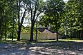
The Tabernacle
The Tabernacle is a unique building located at 829 Holland Road in Scottsville. Listed in 2001, this structure likely served as a place for large gatherings, perhaps for religious or community events. Its design and history offer clues about the social life of the area.
J.L. Turner and Son Building
The J.L. Turner and Son Building is on Old East Main Street at 7th Street in Scottsville. This building, added to the list in 2001, was likely a commercial building. It shows us what the business district looked like many years ago.
Other Notable Historic Sites
Allen County also has other unique places that are historically significant.
Allen County Poor Farm
The Allen County Poor Farm is located at 3540 Holland Road in Scottsville. This site, listed in 1991, was a place where the county cared for people who couldn't support themselves. It's a reminder of how communities used to provide social welfare.
Big Spring School-Oliver Farmstead
The Big Spring School-Oliver Farmstead includes both a school and a farm, located at 3293 and 3109 Big Springs Road in Settle. This property, added in 2004, tells the story of rural education and farming life in Allen County.
Dumont Hill
Dumont Hill is a historic site located about 0.25 miles north of Kentucky Route 1386 near Scottsville. This area, listed in 2003, is important for its historical significance, though specific details about its past are not always widely known. It could be a site of archaeological interest or a place tied to a significant event.
Why These Places Matter
These historic places in Allen County are more than just old buildings or sites. They are like open books that tell us about the past. They show us how people lived, worked, and built their communities. By protecting these sites, we help future generations understand their heritage and the rich history of Allen County, Kentucky.
Images for kids
-
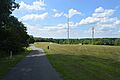
Pathways at Dumont Hill
-

The Dr. Pellie G. Graves House
-
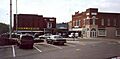
The Public Square in Scottsville
-
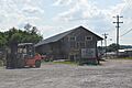
The Scottsville Freight Depot
-
The Scottsville Public Spring
-
The Tabernacle in Scottsville
-

The J.L. Turner and Son Building


