
National Register of Historic Places listings in Atchison County, Kansas facts for kids

Welcome to Atchison County, Kansas! This special place is home to many buildings, homes, and other sites that are super important to history. These places are so special that they are listed on the National Register of Historic Places. Think of it like a hall of fame for old buildings and places that tell amazing stories about the past!
The National Register of Historic Places is a list kept by the United States government. It helps protect and celebrate places that are important to American history, architecture, archaeology, engineering, or culture. When a place is on this list, it means it's recognized as a valuable part of our country's heritage.
In Atchison County, there are 45 different properties and areas that have earned a spot on this important list. Each one has its own unique story and reason for being recognized. Let's explore some of these amazing historic sites!
Historic Buildings in Atchison
Many of Atchison County's historic treasures are found right in the city of Atchison. These buildings show us what life was like long ago. They also show us different styles of architecture, which is the art of designing buildings.
Atchison Santa Fe Freight Depot
The Atchison Santa Fe Freight Depot was built a long time ago, in 1901. It was a busy place where goods were loaded onto and off trains. Imagine all the different things that passed through here! Today, this old depot has been turned into the Santa-Fe Depot Rail Museum. It's a great place to learn about trains and how they helped Atchison grow.

Atchison County Courthouse
The Atchison County Courthouse is a very important building. It's where many of the county's official decisions are made. This grand building was added to the National Register in 1975. Courthouses often have impressive designs, and this one is no exception. It stands at the corner of 5th and Parallel Streets.

Atchison Post Office
The Atchison Post Office, located on Kansas Avenue, has been serving the community for many years. It was listed on the National Register in 1972. Post offices are often central to a town's life, connecting people through letters and packages.
Atchison County Memorial Hall
The Atchison County Memorial Hall is a special place that honors people. It was built to remember those who served our country. This hall, located on Commercial Street, was added to the list in 2007. It serves as a community gathering place.

Benedictine College North Campus Historic Complex
Benedictine College is a well-known college in Atchison. Its North Campus has a collection of historic buildings. These buildings were recognized in 1982. They show the long history of education and religious life in the area.
.jpg)
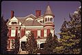
McInteer Villa
The McInteer Villa is a fascinating old house on Kansas Avenue. It was built in 1889 and is known for its unique and somewhat spooky appearance. This house was added to the National Register in 1975. It's a great example of Victorian architecture, which was popular in the late 1800s.
_from_S_1.JPG)
Trinity Episcopal Church
The Trinity Episcopal Church is one of the oldest churches in Atchison. It has been a place of worship for many generations. This beautiful church, located on S. 5th Street, was listed in 1985. Its architecture tells a story of faith and community history.

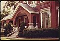
Homes of Famous People and Families
Many historic homes in Atchison County belonged to important people or show us how families lived in the past.
Amelia Earhart Birthplace
One of the most famous historic homes in Atchison is the birthplace of Amelia Earhart. She was a brave and famous pilot who was the first woman to fly solo across the Atlantic Ocean. Her childhood home on North Terrace was listed in 1971. It's a wonderful place to learn about her early life.

Amelia Earhart Historic District
The area around Amelia Earhart's birthplace is also a historic district. This means that a whole group of buildings in that neighborhood are considered historically important. This district was recognized in 2002. It helps preserve the look and feel of the neighborhood from Amelia's time.
Edgar W. Howe House
The Edgar W. Howe House belonged to a famous newspaper editor and author. Edgar W. Howe was known for his writings about small-town life. His home on N. 3rd Street was added to the National Register in 1972. It gives us a peek into the life of an influential writer.
_from_ESE_1.JPG)
Other Notable Homes
Many other beautiful and historic homes are on the list, each with its own story. These include the Francis and Harriet Baker House, the George T. and Minnie Searles Bolman House, the Henry Braun House, and the J. P. Brown House. These homes show different styles of architecture from the past. They also tell us about the families who lived there.
Historic Districts and Other Structures
Besides individual buildings, some entire areas or unique structures are also recognized for their historical value.
Burnes Rental Houses Historic District
The Burnes Rental Houses Historic District includes a group of rental homes on N. 3rd Street. These homes were built for rent and show how people lived and worked in the past. This district was listed in 2005. It gives us an idea of community development.

Stranger Creek Warren Truss Bridge
Not all historic places are buildings! The Stranger Creek Warren Truss Bridge is an old bridge on Haskell Road. It was built using a special design called a Warren Truss, which makes it very strong. This bridge was listed in 2004. It's an important example of early engineering.

Images for kids
-
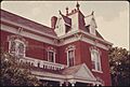
The J. P. Brown House, a Victorian-era home.
-
The W. W. Hetherington House.
-
The H. E. Muchnic House.
-
St. Patrick's Catholic Church, built with local stone.
-
The B. P. Waggener House.


