
National Register of Historic Places listings in Big Horn County, Wyoming facts for kids

Welcome to Big Horn County, Wyoming! This place is full of amazing history, and many of its special spots are listed on the National Register of Historic Places. This list helps protect important buildings, sites, and areas that tell us about the past. Think of it like a hall of fame for historical places!
There are 24 places in Big Horn County that are on this special list. One of them is even a National Historic Landmark, which means it's super important to the history of the entire United States. Let's explore some of these cool historic treasures!
Contents
Exploring Big Horn County's Historic Treasures
Historic Buildings and Community Hubs
Big Horn County has many old buildings that have played a big part in local life. These places often served as gathering spots or important centers for towns.
- American Legion Hall, Post 32 (Greybull): This building, listed in 2014, was a meeting place for veterans. It shows how communities honored those who served.
- Basin Republican-Rustler Printing Building (Basin): Built in 1976, this building was home to a local newspaper. Newspapers were vital for sharing news and information in the past.
- Carey Block (Greybull): Listed in 2009, this building likely housed businesses or offices. It's a piece of Greybull's downtown history.
- Hyart Theater (Lovell): This theater, listed in 2009, is a beautiful old movie house. Imagine watching films here decades ago!
- Lower Shell School House (Greybull): This old schoolhouse, listed in 1985, reminds us of how children learned in the past. It's a simple building that holds many stories.
- U.S. Post Office (Basin and Greybull): Both Basin (1987) and Greybull (1987) have historic post office buildings. These were important places for sending letters and packages, connecting people across distances.
Ancient Sites and Trails
Some of the most fascinating historic places in Big Horn County are much, much older than any building. These sites tell us about the lives of people who lived here thousands of years ago.
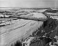
- Bad Pass Trail (Warren): This ancient trail, listed in 1975, runs along the Bighorn River. It was used by Native Americans for travel and trade for a very long time.
- Bear Creek Ranch Medicine Wheel (Greybull): Listed in 1987, this is a special stone circle built by Native Americans. Medicine wheels were used for ceremonies or as calendars.
- Black Mountain Archeological District (Shell): This large area, listed in 1987, contains many ancient sites. Archaeologists study these spots to learn about early human life.
- Bridger Immigrant Road-Dry Creek Crossing (Cody): Listed in 1975, this was part of a trail used by pioneers moving west. It shows the paths people took to settle new lands.
- Hanson Site (Shell): This important archaeological site, listed in 1978, has helped experts learn about ancient hunting practices.
- Medicine Lodge Creek Site (Hyattville): Listed in 1973, this site is famous for its rock art and evidence of human activity over thousands of years.
- Medicine Wheel-Medicine Mountain (Kane): This is the only National Historic Landmark in Big Horn County, listed in 1969. It's a large, mysterious stone wheel on a mountain top, built by Native Americans. It's a very sacred place with deep cultural meaning.
- Paint Rock Canyon Archeological Landscape District (Hyattville): This district, listed in 1990, is another area rich with ancient history, including rock shelters and tools.
- Southsider Shelter (Ten Sleep): Listed in 2012, this rock shelter provided protection for ancient people. It's a window into how they lived and survived.
Cool Bridges and Ranches
Big Horn County also has historic bridges and old ranches that show how people lived and worked in the past.
- EJE Bridge over Shell Creek (Shell): This bridge, listed in 1985, is an example of early engineering in the area.
- EJP County Line Bridge (Hyattville): Another historic bridge, listed in 1985, that helped connect communities.
- EJZ Bridge over Shoshone River (Lovell): Listed in 1985, this bridge allowed people to cross the Shoshone River, which was important for travel and trade.
- Rairden Bridge (Manderson): This bridge, listed in 1985, also played a role in connecting different parts of the county.
- M L Ranch (Lovell): Listed in 1992, this historic ranch shows what life was like for ranchers in Wyoming. Ranches were a big part of the state's economy and culture.
These historic places help us understand the rich and diverse history of Big Horn County, from ancient times to more recent days. They are important reminders of the people and events that shaped this part of Wyoming.
Images for kids
-
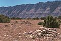
The Bad Pass Trail, an ancient pathway used for centuries.
-
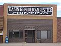
The Basin Republican-Rustler Printing Building, once home to a local newspaper.
-
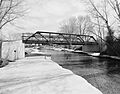
The EJE Bridge over Shell Creek, an example of early bridge building.
-
The EJZ Bridge over the Shoshone River, connecting communities.
-
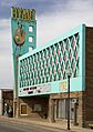
The historic Hyart Theater in Lovell.
-
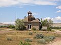
The Lower Shell School House, where children learned long ago.
-
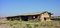
A bunkhouse at the M L Ranch, showing ranch life.
-
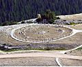
The Medicine Wheel-Medicine Mountain, a sacred and ancient site.
-
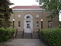
The U.S. Post Office in Basin, a historic community building.


