
National Register of Historic Places listings in Bonneville County, Idaho facts for kids

Welcome to Bonneville County, Idaho! This page is all about the special places here that are listed on the National Register of Historic Places. Think of it like a Hall of Fame for buildings, areas, and other important spots that tell us about the past.
Contents
What is the National Register of Historic Places?
The National Register of Historic Places is an official list kept by the United States government. It includes buildings, sites, objects, and districts that are important in American history, architecture, archaeology, engineering, or culture. When a place is added to this list, it means it's recognized as a valuable part of our country's heritage. It helps protect these places and makes people more aware of their importance.
Historic Places in Bonneville County
Bonneville County has many interesting places on the National Register. These spots help us understand what life was like long ago and how the area grew. There are 32 places listed in the county, and more might be added in the future!
Here are some examples of the types of historic places you can find:
Old Farmsteads
Some of the oldest listings are farmsteads, which are old farms with their original buildings. These show us how early settlers lived and worked the land.
- Andrew and Johanna M. Beckman Farm (Idaho Falls): Added in 1992, this farm tells a story of early farming life.
- Oscar and Christina Beckman Farmstead (Idaho Falls): Also added in 1991, another example of a historic farm.
- Carl S. and Lizzie Sealander Farmstead (Idaho Falls): Listed in 1992, showing how families built their lives here.
Important Buildings in Idaho Falls
Many historic buildings are in Idaho Falls, the county seat. These buildings often served important roles in the community.
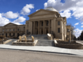
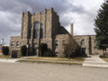
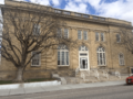
- Bonneville County Courthouse (Idaho Falls): Built in 1979, this is where local government decisions are made.
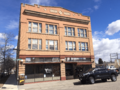
- Bonneville Hotel (Idaho Falls): Listed in 1984, this old hotel was once a busy place for travelers and locals.
- Farmers and Merchants Bank Building (Idaho Falls): Added in 1984, this building was important for the town's economy.
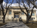
- First Presbyterian Church (Idaho Falls): Listed in 1978, this church has been a spiritual center for many years.
- Holy Rosary Church (Idaho Falls): Added in 2002, another significant religious building.
- Hotel Idaho (Idaho Falls): Listed in 1984, another historic hotel that saw many visitors.
- I.O.O.F. Building (Idaho Falls): Added in 1984, this building belonged to a fraternal organization, the Independent Order of Odd Fellows.
- Idaho Falls City Building (Idaho Falls): Listed in 1984, this was an important center for city operations.
- Idaho Falls Public Library (Idaho Falls): Added in 1984, this library has served the community for decades.
- Kress Building (Idaho Falls): Listed in 1984, this building was once a popular department store.
- Montgomery Ward Building (Idaho Falls): Added in 1984, another former department store building.
- Rocky Mountain Bell Telephone Company Building (Idaho Falls): Listed in 1984, showing the early days of telephone communication.
- Shane Building (Idaho Falls): Added in 1984, another historic commercial building.
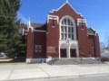
- Trinity Methodist Church (Idaho Falls): Listed in 1977, an important church in the community.
- U.S. Post Office (Idaho Falls): Added in 1979, this building handled mail for the growing city.
- Underwood Hotel (Idaho Falls): Listed in 1984, another historic hotel.
Historic Districts
Sometimes, a whole area or group of buildings is important. These are called historic districts.
- Eleventh Street Historic District (Idaho Falls): Listed in 1997, this area includes many historic homes and buildings.
- Idaho Falls Airport Historic District (Idaho Falls): Added in 1997, this district shows the history of aviation in the area.
- Ridge Avenue Historic District (Idaho Falls): Listed in 1993, another neighborhood with many historic buildings.
- Art Troutner Houses Historic District (Idaho Falls): Added in 2008, this district features unique homes designed by a famous architect.
Other Unique Sites
- Eagle Rock Ferry (Idaho Falls): Listed in 1974, this site reminds us of how people used to cross the Snake River before bridges were common.
- Iona Meetinghouse (Iona): Built in 1887 and listed in 1973, this building is now an art gallery. It's a great example of early community gathering places.
- New Sweden School (Idaho Falls): Added in 1991, this old school building tells us about education in the past.
- Salt River Hydroelectric Powerplant (Wayan): Listed in 1993, this power plant shows how electricity was brought to the region. It even extends into Wyoming!
- Shelton L.D.S. Ward Chapel (Ririe): Added in 1979, this chapel was an important religious and community center.
- Wasden Site (Owl Cave) (Idaho Falls): Listed in 1976, this is a very important archaeological site, meaning it holds clues about ancient human life. Its exact location is kept private to protect it.
Why are these places important?
These historic places are like pieces of a puzzle that help us understand the past. They show us how people lived, worked, and built communities in Bonneville County. By recognizing and protecting them, we make sure that future generations can also learn from and appreciate this rich history. It's a way of keeping our stories alive!
Former Listings
Sometimes, places are removed from the National Register. This can happen if a building is changed too much, or if it's destroyed.
- Eagle Rock Street Historic District (Idaho Falls): This district was listed in 1973 but later removed.
- Snake River Ranger Station (Swan Valley): Listed in 1983, this station was delisted in 1993.
Images for kids
-
The Bonneville County Courthouse in Idaho Falls.
-
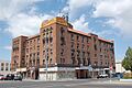
The historic Bonneville Hotel in Idaho Falls.
-
The First Presbyterian Church in Idaho Falls.
-
Holy Rosary Church in Idaho Falls.
-
The Hotel Idaho Building in Idaho Falls.
-

The I.O.O.F. Building in Idaho Falls.
-
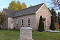
The Iona Meetinghouse, now an art gallery.
-
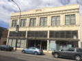
The Kress Building in Idaho Falls.
-

The Shelton L.D.S. Ward Chapel near Ririe.
-
Trinity Methodist Church in Idaho Falls.
-
The old U.S. Post Office in Idaho Falls.
-

Image representing a site with a restricted address, like the Wasden Site.


