
National Register of Historic Places listings in Brooke County, West Virginia facts for kids

Brooke County, West Virginia, is home to many amazing places that are super important to history! These special spots are listed on the National Register of Historic Places. This is like a special list kept by the United States government. When a building, a whole neighborhood, or even a landmark is on this list, it means it's really old and has a cool story to tell. It's important to protect these places so future generations can learn from them.
In Brooke County, there are 24 different places on this list. Two of them are even more special and are called National Historic Landmarks. That means they are super important to the history of the entire country!
Contents
Exploring Brooke County's Historic Treasures
Let's take a look at some of the cool historic places you can find in Brooke County. Many of these are old homes or important buildings that show us what life was like a long time ago.
Historic Spots in Wellsburg
Wellsburg is a town in Brooke County with lots of history. Many of its old buildings and areas are on the National Register.
Beautiful Old Homes
Wellsburg has many grand old houses that are now historic landmarks.
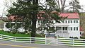
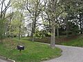
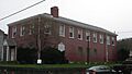
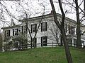
- Beallmore is a lovely old house located on Pleasant Avenue. It was added to the list in 1986.
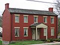
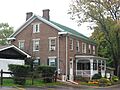
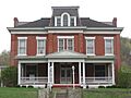
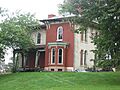
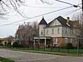
- The Danforth Brown House is another historic home on Washington Pike. It became a registered site in 1992.
- The Gen. I.H. Duval Mansion is a big house on Pleasant Avenue, named after a general. It joined the list in 1986.
- Elmhurst is another historic mansion on Pleasant Avenue, also added in 1986.
- The David and Lucy Tarr Fleming Mansion is a beautiful old home on Pleasant Avenue, recognized in 1986.
- The Lewis Hall Mansion on Pleasant Avenue is another historic house from 1986.
- The Kirker House on Grand Avenue was added to the list in 1986.
- The Harry and Louisiana Beall Paull Mansion is a historic home on Pleasant Avenue, also recognized in 1986.
- The John C. Reeves House on Reeves Drive is a more recent addition to the list, from 2006.
- The Lucy Tarr Mansion on Pleasant Avenue is another historic home, added in 1986.
Other Important Wellsburg Sites
Besides homes, Wellsburg has other interesting historic places.
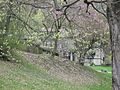
- The Brooke Cemetery is a historic burial ground on Pleasant Avenue. It was added to the National Register in 1986.
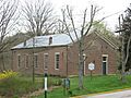
- Miller's Tavern is an old building at 6th and Main Streets. Taverns were like inns or restaurants in the past. It became historic in 1978.
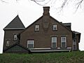
- The Nicholls House and Woolen Mill Site is located near Buffalo Creek. This site includes an old house and where a mill used to be. It was added in 1997.
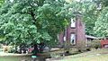
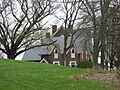
- The Inn at Fowlerstown on Washington Pike is an old inn, recognized in 1992.
- The Wellsburg Wharf is a historic spot on the riverfront at 6th and Main Streets. Wharves are places where boats dock. It was added in 1979.
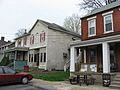
- The Wellsburg Historic District is not just one building, but a whole area along West Virginia Route 2. This district includes many historic buildings that together tell the story of Wellsburg. It was recognized in 1982.
- Vancroft on Brinker Road is another historic district, added in 1986.
Historic Spots in Bethany
Bethany is another town in Brooke County with a rich history, especially linked to Bethany College.
National Historic Landmarks in Bethany
Bethany is special because it has two National Historic Landmarks!
- The Alexander Campbell Mansion is east of Bethany on West Virginia Route 67. Alexander Campbell was a very important religious leader. His mansion became a National Historic Landmark in 1970.
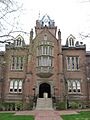
- Old Main, Bethany College is a main building on the Bethany College campus. This building is also a National Historic Landmark, recognized in 1970. It's a very important part of the college's history.
Other Historic Places in Bethany
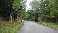
- The Bethany Historic District is an area around West Virginia Route 67 that includes many historic buildings in the town. It was added to the list in 1982.
- The Delta Tau Delta Founders House on Main Street is where the Delta Tau Delta fraternity was founded. It became a historic site in 1979.
- The Old Bethany Church on Main and Church Streets is a historic church building. It was added to the list in 1976.
- Pendleton Heights is another historic building on the Bethany College campus. It was recognized in 1975.
These historic places help us remember the past and understand how Brooke County grew and changed over time. They are important parts of West Virginia's story!
Images for kids
-
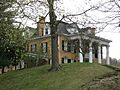
Beallmore
-
Bethany Historic District
-
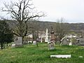
Brooke Cemetery
-
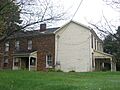
Danforth Brown House
-
Alexander Campbell Mansion
-
Delta Tau Delta Founders House
-
Gen. I.H. Duval Mansion
-
Elmhurst
-
David and Lucy Tarr Fleming Mansion
-
Lewis Hall Mansion
-
Inn at Fowlerstown
-
Kirker House
-
Miller's Tavern
-
Nicholls House and Woolen Mill Site
-
Old Bethany Church
-
Old Main, Bethany College
-
Harry and Louisiana Beall Paull Mansion
-
Pendleton Heights
-
John C. Reeves House
-
Lucy Tarr Mansion
-
Vancroft
-
Wellsburg Historic District
-
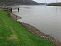
Wellsburg Wharf


