
National Register of Historic Places listings in Campbell County, Kentucky facts for kids

Campbell County, Kentucky, is home to many special places listed on the National Register of Historic Places. This is a list of these important buildings and areas. The National Register is like a special club for historic sites in the United States. It helps protect places that are important to our country's history and culture.
When a place is on the National Register, it means it has been recognized for its historical, architectural, archaeological, engineering, or cultural importance. This recognition helps people understand and appreciate the past. It also encourages communities to preserve these sites for future generations. In Campbell County, there are 66 properties and districts currently on this list. One property was on the list before but has since been removed.
Contents
What is the National Register of Historic Places?
The National Register of Historic Places is the official list of places in the United States that are worth saving. It's part of a program by the federal government to help protect historic buildings, structures, objects, sites, and districts. Being on the Register means a place is important to local, state, or national history.
It's not just about old buildings. It can be a place where something important happened, a special design, or even a whole neighborhood that shows how people lived long ago. When a place is listed, it gets some benefits. For example, it might get special grants or tax breaks to help with its upkeep. It also helps people learn about the past and why these places matter.
Exploring Historic Sites in Campbell County
Campbell County has many different types of historic places. These include old homes, schools, churches, and even entire neighborhoods. Each one tells a unique story about the area's past. Let's look at some examples of these fascinating sites.
Historic Homes and Farms
Many of the listings in Campbell County are historic homes and farms. These buildings show us how people lived and worked many years ago. They often have unique architectural styles from different time periods.
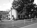
- The Baumann House in Camp Springs is one such historic home. It was listed on the Register in 1983.
- Bellevue in Newport is another important home. It was the homestead of James Taylor, Jr. (Kentucky), a key figure in Kentucky's early history. This house was added to the Register in 1976.

- The Blau's Four Mile House (also known as Reitman House) in Camp Springs is another example of a historic farm building. It was listed in 1983.
,_Camp_Springs,_Kentucky.jpg)
- The Camp Springs House is also located in Camp Springs. This building gives us a glimpse into the rural life of the past. It joined the Register in 1983.

- The Foote-Fister Mansion in Bellevue is a grand home recognized in 1988. It stands as a reminder of the elegant architecture of its time.

- The Southgate-Parker-Maddux House in Newport is another significant residence. Listed in 1977, it reflects the architectural styles popular when it was built.

- The August Sauer House in Newport was added to the Register in 1997. It is a well-preserved example of historic residential architecture.

- The Joseph Seiter House in Bellevue, listed in 1986, is another historic home that contributes to the area's rich past.

- The Charles Wiedemann House in Newport, recognized in 1984, is a notable building that showcases the architectural trends of its era.

Historic Schools and Public Buildings
Schools and courthouses are important parts of a community's history. They often served as central gathering places and symbols of civic life.
- Bellevue High School, located at Washington and Center Streets, was listed in 1986. This building has seen many students pass through its doors over the years.

- The Campbell County Courthouse at Newport is a key civic building. It was recognized in 1988 for its historical importance to the county.

- Dayton High School, now called Schoolhouse Flats, was listed in 1985. It served the community of Dayton for many years.

- St. Vincent de Paul School in Newport was added to the Register in 1989. This school has a long history of educating local children.

Churches and Cemeteries
Churches and cemeteries are often among the oldest and most beautiful structures in a community. They reflect the spiritual and social history of the people.
- Sacred Heart Church in Bellevue was listed in 1974. Its architecture and history make it a significant landmark.

- St. John the Baptist Roman Catholic Church in Wilder was recognized in 1980. It has served its congregation for many decades.
- St. Paul's Episcopal Church in Newport, listed in 1980, is another beautiful historic church.

- The St. John's Lutheran Cemetery in Alexandria, listed in 1983, is a historic burial ground.
- St. Joseph's Catholic Church and Cemetery in Alexandria was recognized in 1983. These sites are important for understanding the religious and community life of the past.
- The Salem Methodist Episcopal Church and Parsonage in Newport was listed in 1986. It is a significant part of the city's religious history.

Historic Districts
Sometimes, it's not just one building that's historic, but a whole area. These are called "historic districts." They are special because they show how a neighborhood or part of a city looked and felt in the past.
- The Cote Brillante Historic District in Newport was listed in 2005. It includes parts of several streets, showing a historic neighborhood.

- The East Newport Historic District was recognized in 1983. It covers an area roughly bounded by the C&O railroad line, 6th, Saratoga, and Oak Streets.

- The Fairfield Avenue Historic District in Bellevue, listed in 1988, highlights a historic commercial and residential street.

- The Fort Thomas Commercial District and the Fort Thomas Military Reservation District are both in Fort Thomas. The military reservation district, listed in 1986, shows the historic layout of a former military base.
- The Mansion Hill Historic District (also known as East Row Historic District) in Newport is a large area with many historic homes. It was listed in 1980 and later expanded.

- The Monmouth Street Historic District in Newport, recognized in 1996, covers a significant commercial street.

- The Newport Courthouse Square Historic District was listed in 2010. It includes the area around the courthouse, showing its historical importance as a civic center.

- The Taylor's Daughters Historic District in Bellevue, listed in 1988, is another residential area with historical significance.

- The York Street Historic District in Newport, recognized in 1995, highlights another important street with historic buildings.

Other Notable Listings
Campbell County also has other interesting historic sites that don't fit neatly into the above categories.
- The Doyle Country Club in Dayton was listed in 2017. It represents a historic recreational site.
- The Kort Grocery in Camp Springs, listed in 1983, is an example of a historic local business.

- The Marianne Theater in Bellevue, recognized in 2015, is a historic entertainment venue.

- The Newport and Cincinnati Bridge, also known as the Newport Southbank Bridge or "Purple People Bridge," crosses the Ohio River. It was listed in 2001 and is a significant engineering feat.

- The Posey Flats in Newport was once a historic building listed in 1987. However, it was later destroyed and is now the site of Newport on the Levee.

- The Third Street Motor Car Company Building in Newport was listed in 2002. It tells a story about the early days of cars and transportation.

- The U.S. Army Fort Thomas Mess Hall in Fort Thomas was recognized in 1980. This building played a role in the daily life of soldiers stationed there.
These are just some of the many historic places in Campbell County, Kentucky. Each one helps us understand the rich history of the area and the people who lived there.
Images for kids
-
Baumann House

