National Register of Historic Places listings in Charlotte County, Virginia facts for kids
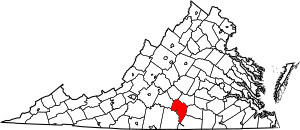
Charlotte County, Virginia, is a place with a rich history! Many old buildings and important places in the county are protected because they are part of the National Register of Historic Places. This is a special list kept by the United States government. It helps make sure that important historical sites are preserved for future generations to learn from and enjoy.
In Charlotte County, there are 19 different places listed on the National Register. These include old homes, courthouses, bridges, and even a railroad station. Each one tells a unique story about the past.
Contents
Historic Places in Charlotte County
Many interesting places in Charlotte County are on the National Register. Let's explore some of them!
Charlotte County Courthouse
The Charlotte County Courthouse is a very important building. It is located in the town of Charlotte Court House. This courthouse has been a center for community life and law for a long time. It was added to the National Register in 1980. The area around the courthouse is also special.
Charlotte Court House Historic District
The Charlotte Court House Historic District includes the courthouse and other old buildings nearby. This whole area shows what a historic Virginia town looked like. It helps us imagine what life was like many years ago. This district was recognized in 1995.
Old Homes and Farms
Charlotte County has many beautiful old homes and farms that are part of its history.
Annefield
Annefield is a historic home located in Saxe, Virginia. It was built a long time ago and shows the style of homes from that period. It was added to the National Register in 2009.
Four Locust Farm
Four Locust Farm is another historic property in Keysville. Farms like this played a big role in the economy and daily life of early Virginia. This farm was listed in 2009.
Gravel Hill
Gravel Hill is a historic plantation near Charlotte Court House. Plantations were large farms, and many of them have interesting stories about the people who lived and worked there. Gravel Hill was added to the list in 2001.
Greenfield
Greenfield is another historic home located east of Charlotte Court House. It became a protected site in 1973.
Maple Roads
Near Keysville, you can find Maple Roads, a historic property listed in 2002. These old homes often have unique architecture and tell us about how people lived in the past.
Mulberry Hill
Mulberry Hill is located north of Randolph. This historic site was added to the National Register in 1973.
Roanoke Plantation
Roanoke Plantation is another historic plantation located west of Saxe. It was recognized in 1973.
Staunton Hill
Staunton Hill is a grand historic estate near Brookneal. It was listed on the National Register way back in 1969, making it one of the earlier sites to be recognized in the county.
Westview
Westview is a historic home near Brookneal. It was added to the National Register in 2000.
Woodfork
Woodfork is a historic home located near Charlotte Court House. It was listed in 2002.
Important Public and Commercial Sites
Not all historic places are homes. Some are buildings that served the community or helped with transportation.
Keysville Railroad Station
The Keysville Railroad Station is an important building in Keysville. Railroads were once the main way people and goods traveled across the country. This station reminds us of that time. It was added to the National Register in 2008.
Clarkton Bridge
The Clarkton Bridge is a historic bridge that crosses the Staunton River. Bridges are vital for connecting communities. This bridge was listed in 2007 and even extends into neighboring Halifax County.
Salem School
The Salem School in Red Oak is a historic school building. Schools are important places where communities grow and learn. This school was added to the National Register in 1998.
Other Unique Historic Sites
Red Hill Patrick Henry National Memorial
Red Hill is a very special place. It is the last home and burial place of Patrick Henry, a famous American patriot who said, "Give me liberty, or give me death!" It is now a national memorial. This important site was listed in 1978.
Toombs Tobacco Farm
The Toombs Tobacco Farm in Red Oak shows us how important tobacco farming was to the history of Virginia. This farm was added to the National Register in 2000.
Wade Archeological Site
The Wade Archeological Site near Randolph is a place where archaeologists study the past by digging up old artifacts. These sites help us learn about ancient cultures and how people lived long, long ago. This site was listed in 2003.
Watkins House
The Watkins House in Keysville is another historic home that was added to the National Register in 2004.
Images for kids


