
National Register of Historic Places listings in Clark County, Indiana facts for kids

Have you ever wondered about old buildings or special places that tell a story about the past? In Clark County, Indiana, there's a list of these important spots called the National Register of Historic Places. This list helps protect and celebrate places that are special because of their history, architecture, or what happened there. Think of it like a Hall of Fame for historic sites!
There are 21 amazing places in Clark County that are on this list. Each one has a unique story to tell about Indiana's past. Some are old homes, some are bridges, and some are even old industrial sites. Let's explore some of these cool historic spots!
Contents
What is the National Register of Historic Places?
The National Register of Historic Places is the official list of the nation's historic places worth saving. It's part of a program by the United States government. When a place is added to this list, it means it's recognized as important to American history. This can help protect it and sometimes even provide funding for its care.
To get on the list, a place must be old enough (usually at least 50 years old) and have special meaning. This meaning could be because of its architecture, its connection to important people or events, or because it helps us understand history.
Cool Historic Spots to Explore
Clark County is full of fascinating places that have made it onto the National Register. Let's look at a few that stand out!
The Howard Steamboat Museum
One of the most famous places on the list is the Howard Steamboat Museum in Jeffersonville. This beautiful mansion was once the home of the Howard family, who were famous for building steamboats. Imagine living in a house built by people who created huge boats that traveled the Ohio River!
The museum shows what life was like for this important family. It also teaches visitors all about the steamboat industry. Steamboats were a huge part of transportation and trade in the past. This museum helps us remember that exciting time.
Old Clarksville Site
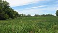
Near the Ohio River in Clarksville, you'll find the Old Clarksville Site. This area is super important because it's where George Rogers Clark founded the first American settlement in the Northwest Territory in 1783. Clark was a hero of the American Revolutionary War. He was a military leader who helped the United States gain control of this vast territory.
This site reminds us of the early days of Indiana. It shows where brave pioneers started new lives and built communities. It's a place where you can almost feel the history of the frontier.
George Rogers Clark Memorial Bridge
Another impressive site is the George Rogers Clark Memorial Bridge. This huge bridge crosses the Ohio River, connecting Jeffersonville, Indiana, with Louisville, Kentucky. It's named after the same George Rogers Clark we just talked about!
Bridges like this are not just ways to get from one place to another. They are also amazing examples of engineering. This bridge has been a vital link between the two states for many years. It's a reminder of how important rivers and bridges were for travel and trade.
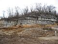
Historic Lime Kilns and Quarries
In Utica Township, you can find several historic lime kilns and quarries. These include the Mitchell P. Howes' Lime Kiln and Quarry, Samuel Starkweather's Lime Kiln and Quarry, and Moses H. Tyler Company Lime Kiln and Quarry No. 1.
What's a lime kiln? It's a special type of oven used to heat limestone. When limestone is heated, it turns into lime. Lime was a very important material in the past. It was used for building, farming, and even making cement. These old kilns and quarries show how people used natural resources to build and grow communities long ago. They are a cool look into early industry in the area.
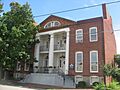
Old Jeffersonville Historic District
The Old Jeffersonville Historic District is a whole area in Jeffersonville that is recognized for its historic value. This district includes many old buildings, streets, and homes. Walking through it is like stepping back in time!
Historic districts are important because they preserve the overall look and feel of a historic neighborhood. They show how a town developed over time. This district helps us appreciate the unique architecture and community spirit of old Jeffersonville.
Other Notable Places
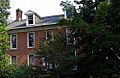
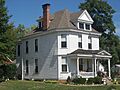
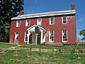
Many other places in Clark County are also on the National Register. These include historic farms like the Abbott-Holloway Farm and the Bottorff-McCulloch Farm. There are also beautiful old homes such as the Thomas Downs House, the Benjamin Ferguson House, and the Henry French House. Each of these places has its own story and adds to the rich history of Clark County.
The Spring Street Freight House in Jeffersonville is another interesting site. It was once a busy depot for the Big Four Railroad. This building reminds us of the importance of railroads in connecting towns and moving goods across the country.
Former Listing
Sometimes, a place might be removed from the National Register. This happened with the Borden Institute in Borden. It was once a school, but it was later taken off the list because it was demolished. This shows that while the National Register aims to protect historic places, sometimes they can still be lost.
Images for kids
-
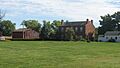
The historic Abbott-Holloway Farm.
-
The Bottorff-McCulloch Farm.
-
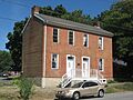
The Thomas Downs House in Charlestown.
-
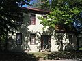
The Benjamin Ferguson House.
-
The Henry French House.
-
The Grisamore House.
-
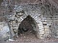
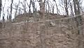
Mitchell P. Howes' Lime Kiln and Quarry.
-
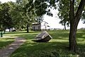
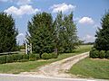
A reproduction of George Rogers Clark's cabin at the Old Clarksville Site.
-
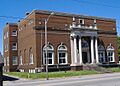
A building in the Old Jeffersonville Historic District.
-
The Smith-Sutton Site.
-
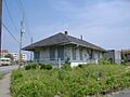
The Spring Street Freight House.
-
Samuel Starkweather's Lime Kiln.
-
Moses H. Tyler Company Lime Kiln and Quarry No. 1.
-
The Watson House in Charlestown.
-
The John Work House.


