
National Register of Historic Places listings in Colbert County, Alabama facts for kids

Colbert County in Alabama is home to many amazing places that tell us about history! These special spots are listed on the National Register of Historic Places. Think of it like a super important list of buildings, areas, and sites that are worth protecting because they teach us so much about the past.
In Colbert County, there are 30 places on this list. Three of them are even more special and are called National Historic Landmarks. These are places that are important to the history of the entire United States! You can even see many of these places on a map using their special coordinates.
Contents
Exploring Colbert County's Historic Treasures
Colbert County has a rich history, and many of its buildings and sites are preserved for future generations. Let's explore some of these fascinating places!
Famous Homes and Buildings
Many historic homes in Colbert County offer a peek into how people lived long ago.
Barton Hall: A Grand Old Home

Barton Hall is a huge, beautiful house located near Cherokee. It was built a long time ago, and it's so important that it's one of the three National Historic Landmarks in the county. Imagine living in a house with so much history! It was added to the National Register on November 7, 1973.
Belle Mont: A Southern Mansion

Southeast of Tuscumbia, you'll find Belle Mont. This grand home was listed on the National Register on February 23, 1982. It's a great example of old Southern architecture.
Ivy Green: Helen Keller's Childhood Home

One of the most famous places in Tuscumbia is Ivy Green, the childhood home of Helen Keller. Helen Keller was an amazing person who became deaf and blind as a child but learned to communicate and became a world-famous author and activist. This house is a National Historic Landmark, recognized on August 25, 1970, because of its connection to her inspiring story.
Other Notable Homes
- Chambers-Robinson House in Sheffield, listed on May 14, 1993.
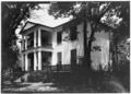
- John and Archibald Christian House near Tuscumbia, added on February 4, 1982.
- Clyde Carter House in Ford City, listed on June 2, 2004.
- John Johnson House near Leighton, added on July 9, 1986.
- Felix Grundy Norman House in Tuscumbia, listed on April 12, 1984.
- The Oaks southeast of Tuscumbia, added on November 7, 1976.
- Preuit Oaks in Leighton, listed on May 8, 1986.
- John Daniel Rather House in Tuscumbia, added on December 16, 1982.
- William Winston House in Tuscumbia, listed on April 15, 1982.
- E.L. Newman Lustron House in Sheffield, a unique metal house listed on February 24, 2000.
Historic Districts and Important Sites
Some areas are so full of history that an entire section or "district" is listed!
Colbert County Courthouse Square Historic District

The area around the Colbert County Courthouse Square in Tuscumbia is a historic district. This means many buildings in that area are important together. It was listed on May 24, 1973.
Sheffield's Historic Areas
- Nitrate Village No. 1 Historic District in Sheffield, listed on August 30, 1984. This area was important for its role in producing materials during wartime.
- Sheffield Downtown Commercial Historic District includes the main business streets of Sheffield, recognized on May 24, 2010.
- Sheffield Residential Historic District covers a large area of homes in Sheffield, listed on May 16, 2002.
Tuscumbia Historic District

The larger Tuscumbia Historic District was added to the National Register on May 23, 1985. It includes many important buildings and even a bridge, showing the town's long history.
Music and Archeology Sites
Colbert County is also famous for its music history and ancient sites.
FAME Recording Studios

In Muscle Shoals, you'll find the Florence, Alabama Music Enterprises (FAME) Recording Studios. This studio is super famous because many legendary musicians recorded hit songs here! It was listed on November 29, 2016, recognizing its huge impact on music history.
Muscle Shoals Sound Studio

Another iconic music spot is the Muscle Shoals Sound Studio in Sheffield. Like FAME, this studio played a big part in creating the "Muscle Shoals Sound" that influenced music worldwide. It was added to the National Register on June 2, 2006.
Ancient Sites
- Buzzard Roost near Cherokee, listed on November 7, 1976.
- La Grange Rock Shelter near Leighton, added on June 13, 1974. This site is restricted, meaning its exact location is kept private to protect it.
- Rock Creek Archeological District near Maud, listed on June 26, 1990. This is another restricted site.
- Seven Mile Island Archeological District near Sheffield, added on April 16, 1979. This is also a restricted site.
- Tuscumbia Landing Site west of Sheffield, listed on June 10, 1982. This was an important landing spot along the river.
Wilson Dam: A National Landmark

The mighty Wilson Dam on the Tennessee River is another National Historic Landmark in Colbert County, recognized on November 13, 1966. This huge dam helps control the river and generate electricity, and it's an amazing example of engineering. It even extends into Lauderdale County!
These are just some of the incredible historic places in Colbert County that are preserved for everyone to learn from and enjoy. They help us understand the past and appreciate the stories of the people who lived here before us.
Images for kids
-
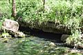
Buzzard Roost Spring
-

John and Archibald Christian House
-
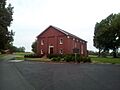
Johnson's Woods
-
Old Brick Presbyterian Church
-
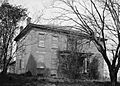
William Winston House


.jpg)
