
National Register of Historic Places listings in Cumberland County, North Carolina facts for kids

Cumberland County, North Carolina, is home to many special places listed on the National Register of Historic Places. This is like a national scrapbook of important buildings, sites, and districts that tell us about America's past. These places are protected because they are part of our history and culture. They help us understand how people lived, worked, and built communities long ago.
In Cumberland County, you can find old train stations, historic churches, unique homes, and even parts of military bases that are all recognized for their importance. Exploring these sites is like taking a trip back in time!
Contents
Historic Places in Cumberland County
Many buildings and areas in Cumberland County are listed on the National Register of Historic Places. These places are special because they show us what life was like in the past.
Fayetteville's Historic Gems
Fayetteville, a big city in Cumberland County, has many historic spots.
Old Train Stations and Travel Hubs
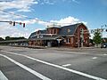
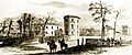
- Atlantic Coast Line Railroad Station: This old train station at 472 Hay Street in Fayetteville was built a long time ago. It was added to the National Register in 1982. Imagine all the people who traveled through here!
- Cape Fear and Yadkin Valley Railway Passenger Depot: Located at 148 Maxwell Street, this depot was another important train stop in Fayetteville. It joined the list in 1983. These stations were busy places where people arrived and departed.
Important Buildings and Homes
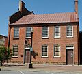
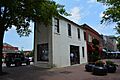
- Barge's Tavern: This building at 519 Ramsey Street in Fayetteville was listed in 1983. Taverns were often gathering places in the past.
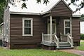
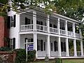
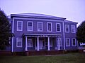
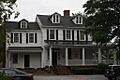
- Belden-Horne House: Also at 519 Ramsey Street, this house was recognized in 1972. It's an example of older homes in the area.
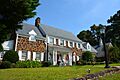
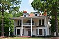
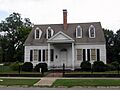
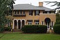
- Brownlea: Found at 405 Southampton Court, this house was added to the list in 2003. It shows different styles of homes from various time periods.
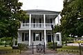
- The Capitol: At 126 Hay Street, this building became historic in 2005. It's a reminder of important events that happened here.
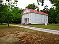
- Cool Spring Place: This historic spot at 119 N. Cool Spring Street was listed in 1972. It's a piece of Fayetteville's early history.
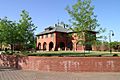
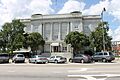
- Cumberland County Courthouse: The courthouse, located at Franklin, Gillespie, and Russell Streets, was listed in 1979. Courthouses are important buildings where laws are made and justice is served.
- Fayetteville Mutual Insurance Company Building: This building at 320 Hay Street was added in 1983. It shows how businesses operated in the past.
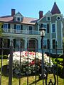
- Fayetteville Women's Club and Oval Ballroom: Also known as Sandford House, this building at 224 Dick Street was listed in 1973. It was a place for social gatherings and community events.
- Kyle House: Located at 234 Green Street, this house was recognized in 1972. It's another example of historic architecture.
- M & O Chevrolet Company: This old car dealership at 412 W. Russell Street was listed in 1983. It tells us about the history of cars and businesses.
- Mansard Roof House: At 214 Mason Street, this house with its unique roof style was listed in 1973.
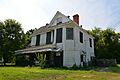
- McCall House: This house at 822 Arsenal Avenue was added in 1983.
- William McDiarmid House: Located at 330 Dick Street, this house was listed in 1983.
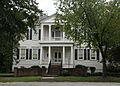
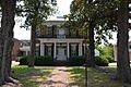
- Nimocks House: At 225 Dick Street, this house was recognized in 1972.
- Phoenix Masonic Lodge No. 8: This lodge at 221 Mason Street was listed in 1983. Lodges were important community groups.
- Edgar Allan Poe House: Found at 206 Bradford Avenue, this house was listed in 1983. It's named after the famous writer, though his connection might be indirect.
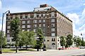
- Prince Charles Hotel: This grand hotel at 430 Hay Street was built in 1925 and listed in 1983. Hotels were central to city life and travel.
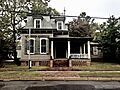
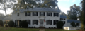
- Sedberry-Holmes House: At 232 Person Street, this house was listed in 1975.
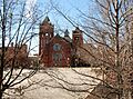
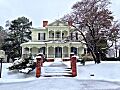
- Dr. Ezekiel Ezra Smith House: This house at 135 S. Blount Street was added to the list in 2015. Dr. Smith was an important educator.
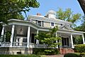
- Frank H. Stedman House: Located at 1516 Morganton Road, this house was listed in 2002.
- Taylor-Utley House: This house at 916 Hay Street was added in 1983.
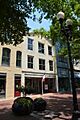
- United States Post Office: The old post office at 301 Hay Street was listed in 1983. Post offices were vital for communication.
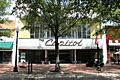
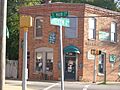
- Waddill's Store: This historic store at 220 Hay Street was listed in 1983. Stores like this were important for daily life.
- Dr. William C. Verdery House: At 1428 Raeford Road, this house was listed in 2007.
Historic Churches
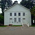
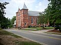
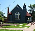
- Camp Ground Methodist Church: Located on Camp Ground Road, this church was listed in 1983. Churches are often central to communities.
- Evans Metropolitan AME Zion Church: This church at 301 N. Cool Spring Street was added in 1983.
- First Baptist Church: At 200 Old Street, this church was listed in 1983.
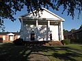
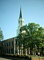
- First Presbyterian Church: Located at Ann and Bow Streets, this church was recognized in 1976.
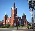
- Hay Street United Methodist Church: This church at Hay Street, Ray, and Old Streets was listed in 1983.
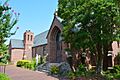
- St. John's Episcopal Church: On Green Street, this church was added in 1974.
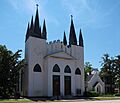
- St. Joseph's Episcopal Church: Located at Ramsey and Moore Streets, this church was listed in 1982.
Schools and Education
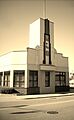
- Massey Hill Classical High School: This school at 1062 Southern Avenue was listed in 2004. It's important for understanding the history of education.
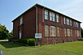
- Orange Street School: Located in the 500 block of Orange Street, this school was added in 1987.
- Seventy-First Consolidated School: This school at 6830 Raeford Road was listed in 2004.
Military History
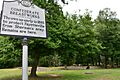
- Confederate Breastworks: These old earth defenses at 2300 Ramsey Street were listed in 1981. They are a reminder of the American Civil War.
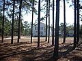
- North Carolina Arsenal Site: Found in Arsenal Park, this site was once a U.S. Army arsenal, later used by the Confederacy. It was listed in 1983.
Special Districts
- Fayetteville Downtown Historic District: This large area includes many streets like Hay, Person, and Green. It was listed in 1999 and protects many historic buildings together.
- Fayetteville Veterans Administration Hospital Historic District: This district at 2300 Ramsey Street was listed in 2012. It includes buildings from an important hospital for veterans.
- Haymount District: This historic neighborhood, roughly along Hillside Avenue, was listed in 1983. It shows how neighborhoods developed over time.
- Liberty Row: This block on Person Street was listed in 1973. It's a row of historic buildings.
- Market House Square District: This area around Hay, Person, Green, and Gillespie Streets was listed in 1983. It includes the famous Market House.
- Pope Air Force Base Historic District: This district includes several buildings at Pope Air Force Base and was listed in 1991. It shows the history of military aviation.
Historic Places Outside Fayetteville
Cumberland County has historic sites beyond Fayetteville too!
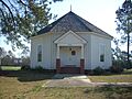
- Big Rockfish Presbyterian Church: This church on SR 2268 in Hope Mills was listed in 1983.
- Cape Fear Baptist Church: Located on SR 2233 in Grays Creek, this church was added in 1983.
- Cool Springs: This historic place off SR 1607 at Cumberland was listed in 1985.
- Devane-MacQueen House: On NC 87 in Grays Creek, this house was listed in 1983.
- Ellerslie: West of Linden on SR 1607, this site was listed in 1974.
- Falcon Tabernacle: This unique building on West Street in Falcon was listed in 1983.
- Hope Mills Historic District: This area in Hope Mills, near the railroad tracks and Lakeview Road, was listed in 1985. It shows the history of this mill town.
- Long Valley Farm: This farm in Spring Lake was listed in 1994. Its exact address is kept private for protection.
- Maxwell House: Located off NC 24 in Stedman, this house was listed in 1985.
- McArthur-Council House: On SR 2244 in Grays Creek, this house was listed in 1983.
- Old Bluff Presbyterian Church: North of Wade on SR 1709, this church was listed in 1974.
- Oak Grove: South of Erwin, near the junction of NC 82 and SR 1875, this site was listed in 1973.
- Robert Williams House: On SR 1728 in Eastover, this house was listed in 1983.
Former Listings
Sometimes, a property might be removed from the National Register. This happened to the Mallett House in Fayetteville. It was listed in 1983 but removed in 1986 because it was moved to the Methodist University campus. Even if a building is moved, its history remains important!
Images for kids
-
The Atlantic Coast Line Railroad Station in Fayetteville.
-
Barge's Tavern.
-
The Belden-Horne House.
-
Big Rockfish Presbyterian Church.
-
Brownlea.
-
The former Camp Ground Methodist Church.
-
The Cape Fear and Yadkin Valley Railway Passenger Depot.
-
Cape Fear Baptist Church.
-
The Capitol building in Fayetteville.
-
Confederate Breastworks.
-
Cool Spring Place.
-
Cross Creek Cemetery Number One.
-
The Cumberland County Courthouse.
-
Evans Metropolitan AME Zion Church.
-
The Falcon Tabernacle.
-
A view of the Fayetteville Downtown Historic District.
-
The Fayetteville Mutual Insurance Company Building.
-
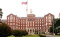
The Fayetteville Veterans Administration Hospital.
-
The Fayetteville Women's Club and Oval Ballroom, also known as Sandford House.
-
First Baptist Church in Fayetteville.
-
First Presbyterian Church in Fayetteville.
-
Hay Street United Methodist Church.
-
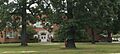
A building in the Haymount District.
-
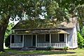
The Holt-Harrison House.
-
A street in the Hope Mills Historic District.
-
The Kyle House.
-
The M & O Chevrolet Company building.
-
The Mansard Roof House.
-
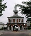
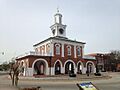
The Market House in Fayetteville.
-
The Market House Square District.
-

Massey Hill Classical High School.
-
The McCall House.
-
The William McDiarmid House.
-
The Nimocks House.
-
Remains of the North Carolina Arsenal Site.
-
Old Bluff Presbyterian Church.
-
Orange Street School.
-
Phoenix Masonic Lodge No. 8.
-
The Edgar Allan Poe House.
-
The Prince Charles Hotel.
-
The Sedberry-Holmes House.
-
Seventy-First Consolidated School.
-
The Dr. Ezekiel Ezra Smith House.
-
St. John's Episcopal Church.
-
St. Joseph's Episcopal Church.
-
The Frank H. Stedman House.
-
The Taylor-Utley House.
-

The U.S. Post Office in Fayetteville.
-
The Dr. William C. Verdery House.
-
Waddill's Store.


.JPG)

.JPG)


.JPG)


.JPG)


.JPG)
.JPG)

.JPG)


.JPG)
.JPG)


.JPG)


.JPG)


.JPG)
.JPG)
