
National Register of Historic Places listings in Delaware County, New York facts for kids

Delaware County, New York, is home to many special places that are important to history. These places are listed on the National Register of Historic Places. This list is like a special club for buildings, areas, and objects that tell us about the past. When a place is on this list, it means it's recognized for its historical or architectural importance.
In Delaware County, there's one super important spot called the John Burroughs Home. It's so special that it's also a National Historic Landmark. This means it's one of the most important historic places in the entire country!
Contents
What is the National Register of Historic Places?
The National Register of Historic Places is the official list of the nation's historic places. It's part of a program by the United States government. This program helps us save and celebrate places that are important to American history.
Why are these places important?
These historic places help us learn about how people lived long ago. They show us old styles of buildings, how towns grew, and where important events happened. Protecting them means future generations can also learn from and enjoy these historical treasures.
Historic Gems in Delaware County
Delaware County has many unique and interesting places on the National Register. Let's explore some of them!
Homes of Famous People
One of the most famous places is the John Burroughs Home, also known as Woodchuck Lodge. It's located near Roxbury. This was the home of John Burroughs, a very famous American naturalist and writer. He loved nature and wrote many books about it. His home is a National Historic Landmark because of his importance.
The Amelita Galli-Curci Estate near Fleischmanns is another special home. It belonged to Amelita Galli-Curci, a world-famous opera singer. Imagine living in a place where such a talented artist once lived!
Historic Churches and Meeting Places
Many old churches in Delaware County are on the list. These buildings often have beautiful architecture and were central to community life.
- The Bloomville Methodist Episcopal Church in Bloomville is a historic church.
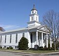
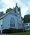
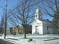
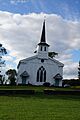
- Christ Episcopal Church in Walton is another beautiful example.
- The Christian Church in East Delhi also holds a place on the register.
- The First Presbyterian Church in Delhi and the First Presbyterian Church of Margaretville are also recognized.
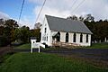
- The Lordville Presbyterian Church and the Old School Baptist Church of Halcottsville are also important religious sites.
- The West Delhi Presbyterian Church, Manse, and Cemetery in West Delhi is a complex of historic religious buildings.
- The West Kortright Presbyterian Church in West Kortright is another significant church.
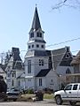
The Congregation Bnai Israel Synagogue in Fleischmanns is special because it's the only synagogue listed in the county. It was built in 1920 and has a unique roof design.
The Hobart Masonic Hall in Hobart was a meeting place for a fraternal organization. These halls often have interesting designs and stories.
Old Schools and Libraries
Learning places are also important!
- The District 10 School near Margaretville has a fascinating story. It was built in the 1820s, taken apart in the 1850s, and then put back together in 1860! It's the only building left from an area that was flooded to create the Pepacton Reservoir.
- Schoolhouse No. 5 near Hamden is another old school building.
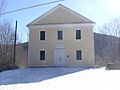
- The Union Free School in Downsville is also on the list.
- The Skene Memorial Library in Fleischmanns is a beautiful library built in 1901. It was designed in a style called Queen Anne/Shingle Style.
Covered Bridges
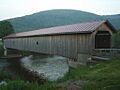
Delaware County has some charming covered bridges. These bridges are special because they are rare and show old building techniques.
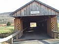
- The Downsville Covered Bridge in Downsville.
- The Fitches Covered Bridge in East Delhi.
- The Hamden Covered Bridge in Hamden.
- The Lower Shavertown Covered Bridge near Methol.
Historic Districts
Some entire areas, or "districts," are listed because they have many historic buildings together.
- The Andes Historic District includes several streets in Andes.
- The Bovina Center Historic District in Bovina Center.
- The Churchill Park Historic District in Stamford.
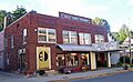
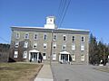
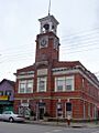
- The Delaware County Courthouse Square District in Delhi includes the courthouse and other buildings around the town square.
- The Franklin Village Historic District in Franklin.
- The Gardiner Place Historic District in Walton.
- The Main Street Historic District in Roxbury.
- The New Kingston Historic District in New Kingston.
- The Pakatakan Artists Colony Historic District in Arkville was once a place where artists gathered.
- The Ravina district near Lordville.
- The Sherwood Family Estate in Delhi.
- The Sidney Historic District in Sidney.
- The Thomson Family Farm in New Kingston.
- The Ulster and Delaware Railroad Depot and Mill Complex in Roxbury includes an old train station and mill buildings.
Other Notable Buildings and Sites
- The Amos Bristol Tavern in West Meredith was an old inn.
- The Burns Family Farm in Bovina is a historic farm.
- The Delaware and Northern Railroad Station in Andes is an old train station.
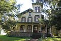
- The Judge Gideon Frisbee House near Delhi is a historic home.
- The Hanford Mill in East Meredith is an old mill.
- The Isaac Hardenbergh House in Roxbury is another historic house.
- The Hotel Delaware in East Branch is an old hotel.
- The Hubbell Family Farm and Kelly's Corners Cemetery in Kelly's Corners.
- The Jackson-Aitken Farm in Andes.
- The Kelly Round Barn in Halcottsville is a unique round barn.
- The MacDonald Farm in Meredith.
- The Maxbilt Theatre in Fleischmanns was built in 1929 and was once a movie theater. It's even being renovated into a dinner theater!
- The McArthur-Martin Hexadecagon Barn in Bloomville is another uniquely shaped barn.
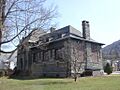
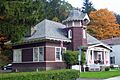
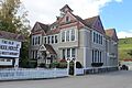
- Murray Hill in Delhi is a historic property.
- New Stone Hall in Franklin.
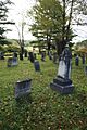
- The Pioneer Cemetery in Sidney is an old burial ground.
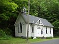
- The Rock Valley School in Rock Valley.
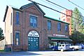
- The Second Walton Armory in Walton, built in the 1890s, is now known as Castle on the Hudson and is used for events.
- The St. John's Church Complex in Delhi.
- The St. Peter's Episcopal Church Complex in Hobart.
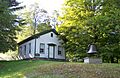
- The Second Old School Baptist Church of Roxbury.
- The Erskine L. Seeley House in Stamford.
- The Walter Stratton House in Roxbury.
- The U.S. Post Office in Delhi and the U.S. Post Office in Walton are historic post office buildings.
- The Van Benschoten House and Guest House in Margaretville.
- The Walton Grange 1454-Former Armory in Walton.
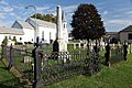
- The West Meredith Cemetery in West Meredith.
Images for kids
-
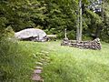
A rock at the John Burroughs Home, a National Historic Landmark.
-
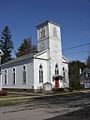
Christ Episcopal Church in Walton.
-
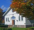
Congregation Bnai Israel Synagogue in Fleischmanns.
-
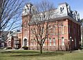
The Delaware County Courthouse in Delhi.
-
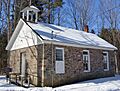
The historic District 10 School.
-
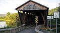
The Downsville Covered Bridge.
-
First Congregational Church of Walton.
-
First Presbyterian Church in Delhi.
-
First Presbyterian Church of Margaretville.
-
Fitches Covered Bridge.
-
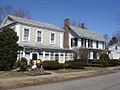
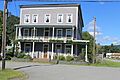
Historic houses in the Franklin Village Historic District.
-
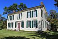
The Judge Gideon Frisbee House.
-
The Galli-Curci Theatre in Margaretville.
-
A building in the Gardiner Place Historic District.
-
The Hamden Covered Bridge.
-
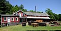
Hanford Mill in East Meredith.
-
The historic Hotel Delaware.
-
Lordville Presbyterian Church.
-
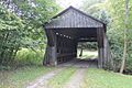
The Lower Shavertown Covered Bridge.
-
Buildings in the Main Street Historic District in Roxbury.
-
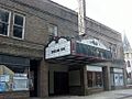
The Maxbilt Theatre in Fleischmanns.
-
Murray Hill House in Delhi.
-
New Stone Hall in Franklin.
-
Monuments in the Pioneer Cemetery in Sidney.
-
The Rock Valley School.
-
A building in the Sidney Historic District.
-
Skene Memorial Library in Fleischmanns.
-
Second Old School Baptist Church of Roxbury.
-

St. John's Church Complex in Delhi.
-
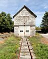
Ulster and Delaware Railroad Depot and Mill Complex in Roxbury.
-
Union Free School in Downsville.
-
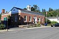
The U.S. Post Office in Delhi.
-
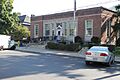
The U.S. Post Office in Walton.
-
Walton Grange 1454-Former Armory.
-
West Delhi Presbyterian Church.
-
West Kortright Presbyterian Church.
-
West Meredith Cemetery.


