
National Register of Historic Places listings in Ellsworth County, Kansas facts for kids

Have you ever wondered about the oldest buildings or special places in your town? In the United States, there's a special list called the National Register of Historic Places. It helps protect important buildings, sites, and objects that have a lot of history or unique design.
Ellsworth County, Kansas, is home to 22 of these amazing historic places. These sites help us learn about the past and understand how people lived long ago. They include old homes, military forts, and even entire downtown areas! Let's explore some of these cool spots.
Exploring Ellsworth County's Historic Treasures
Ellsworth County has many interesting places on the National Register. These sites tell stories about the people and events that shaped the area. From old forts to historic homes, each place offers a peek into the past.
Old Buildings and Downtown Areas
Many historic places are buildings where people lived, worked, or gathered. Some entire parts of towns are also on the list because they show how communities grew.
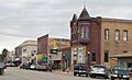
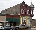
Ellsworth's Historic Downtown
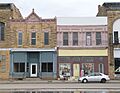
The Ellsworth Downtown Historic District is a special area in Ellsworth, Kansas. It includes many old buildings that show what the town looked like long ago. Walking through this district is like taking a step back in time. You can see the architecture and feel the history of the town's early days.
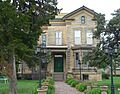
Historic Buildings in Ellsworth
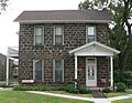
- The Perry Hodgden House is a beautiful old home in Ellsworth. It was built a long time ago and is recognized for its unique design.
- The Insurance Building is another historic spot in Ellsworth. It's an important part of the town's history and its old business district.
- The Arthur Larkin House is located just south of Ellsworth. This house is also a great example of the area's past homes.
- The Ira E Lloyd Stock Farm shows us what old farms in the area were like. It helps us understand how people lived and worked on the land.
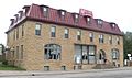
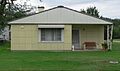
Wilson's Historic Downtown and Buildings
The town of Wilson, Kansas, also has historic areas.
- The Wilson Downtown Historic District #1-Main St. covers a big part of Main Street and nearby streets. It shows the historic center of Wilson.
- The Wilson Downtown Historic District #3-Southside is another historic area in Wilson. It includes old buildings on 27th Street, which was once part of "Old Highway 40."
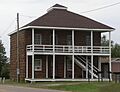
- The Midland Hotel in Wilson is a very old hotel. It was an important place for travelers and locals many years ago.
- The Weinhold House is a historic home in Wilson. It's a great example of the kind of houses built in the area a long time ago.
Important Transportation and Military Sites
Some historic places are important because of how people traveled or because of military history.
Holyrood Santa Fe Depot
The Holyrood Santa Fe Depot is an old train station in Holyrood, Kansas. Train stations were very important for towns in the past. They helped people and goods travel across the country. This depot reminds us of the days when trains were a main way to get around.
Fort Harker
Fort Harker was an important military post in Kansas. It was built to protect settlers and travelers during the 1800s.
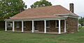
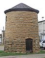
- The Fort Harker Guardhouse is one of the buildings that still stands from the old fort. Soldiers would have guarded this building.
- The Fort Harker Officers' Quarters were where the officers lived. These buildings give us a look into the daily life of soldiers at the fort.
Ancient History: Archeological Sites
Ellsworth County also has many archeological sites. These are places where scientists have found clues about people who lived here thousands of years ago. These sites help us learn about ancient cultures and how early people lived in Kansas. Many of these sites are protected to keep their secrets safe for future study.
Indian Hill Site
The Indian Hill Site near Marquette, Kansas, is one of these important archeological sites. It helps scientists understand the history of Native American tribes in the area.
Images for kids
-
Ellsworth Downtown Historic District
-
Fort Harker Guardhouse
-
Fort Harker Officers' Quarters
-
Perry Hodgden House
-
Insurance Building
-
Arthur Larkin House
-
Midland Hotel in Wilson
-
Weinhold House in Wilson
-
Wilson Downtown Historic District #1-Main St.
-
Wilson Downtown Historic District #3-Southside


_from_NW_1.JPG)
_from_N_1.JPG)

_from_W_1.JPG)

_and_Zeman_buildings_from_N_1.JPG)
