
National Register of Historic Places listings in Foster, Rhode Island facts for kids
This article is about the cool historic places in Foster, Rhode Island that are listed on the National Register of Historic Places. These places are super important because they tell us a lot about the past and how people lived long ago. Think of it like a special list of buildings, farms, and areas that are protected so future generations can learn from them!
Contents
What is the National Register of Historic Places?
The National Register of Historic Places is the official list of places in the United States that are important in American history, architecture, archaeology, engineering, and culture. When a place is added to this list, it means it's recognized as special and worth preserving. It's like giving a building or an area a "historic landmark" badge!
Historic Places in Foster, Rhode Island
Foster, Rhode Island, has several amazing places on this list. Let's explore some of them!
Borders Farm
The Borders Farm is a historic farm located at 31-38 N. Road in Foster, Rhode Island. It was officially added to the National Register of Historic Places on July 29, 2009. This farm gives us a peek into what farming life was like in the past in Rhode Island.

Breezy Hill Site (RI-957)
The Breezy Hill Site (RI-957) is another important spot in Foster. It was listed on September 28, 1985. This site is a bit mysterious because its exact address is restricted, often meaning it's an archaeological site that needs to be protected from disturbance. It likely holds clues about very old human activity in the area.
Clayville Historic District
The Clayville Historic District is a special area that includes parts of both Foster, Rhode Island and Scituate, Rhode Island. It was recognized as historic on December 29, 1988. This district is roughly found around Cole Avenue, Plainfield Pike, Field Hill Road, and Victory Highway. Historic districts are like neighborhoods where many buildings together tell a story about a certain time period or way of life.

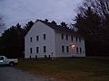
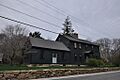
Captain George Dorrance House
The Captain George Dorrance House is a historic home located at 2 Jencks Road in Foster. This house was added to the National Register on March 16, 1972. It's a great example of old architecture and tells us about the people who lived in Foster many years ago.

Foster Center Historic District
The Foster Center Historic District is the heart of historic Foster. This entire area was listed on May 11, 1974. It includes many important buildings that make up the historic center of the town, showing how communities were organized and grew in the past.

Moosup Valley Historic District
Another interesting historic area is the Moosup Valley Historic District, listed on May 11, 1988. This district is roughly bounded by Harrington, Johnson, Moosup Valley, Barb Hill, and Cucumber Hill Roads. It's a collection of historic buildings and landscapes that show the unique history of the Moosup Valley.

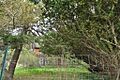
Mount Hygeia
Mount Hygeia is a historic property located on Mt. Hygeia Road. It was added to the National Register on August 12, 1977. This place is also known as the Solomon Drown House. It's famous for being the original home of the 'Rhode Island Greening' apple, a very old and popular type of apple!

Mount Vernon Tavern
The Mount Vernon Tavern is a historic building at 199 Plainfield Pike (which is also Rhode Island Route 14). It was listed on May 8, 1974. Taverns like this were important gathering places in the past, where travelers could rest and people could meet.

Hopkins Mill Historic District
The Hopkins Mill Historic District is another significant area in Foster, added to the list on May 10, 1984. It includes parts of Old Danielson Pike, U.S. Route 6, Maple Rock, and Rams Trail Roads. This district tells the story of the old mill communities that were once very common in New England.

Images for kids
-
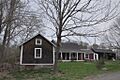
The Borders Farm in Foster, Rhode Island.
-
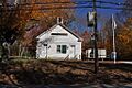
An old school building in the Clayville Historic District.
-
The historic Captain George Dorrance House.
-
A historic building in the Foster Center Historic District.
-
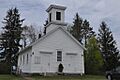
A church located within the Moosup Valley Historic District.
-
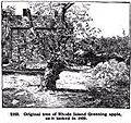
The original Rhode Island Greening apple tree at Mount Hygeia.
-
The historic Mount Vernon Tavern.
-
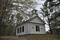
The Hopkins Mills Union Church in the Hopkins Mill Historic District.
