
National Register of Historic Places listings in Fulton County, New York facts for kids

Fulton County, New York, is home to many amazing places that are part of the National Register of Historic Places. This special list includes buildings, areas, and even natural spaces that are important to American history. When a place is on this list, it means it's recognized for its unique past and is protected so future generations can learn from it.
Think of it like a hall of fame for historic sites! In Fulton County, you'll find everything from old homes and factories to a huge park and even a fire tower. These places tell stories about how people lived, worked, and shaped the area over many years. Two of these sites, Johnson Hall and Adirondack Park, are even more special because they are also National Historic Landmarks, meaning they are super important to the entire country!
Contents
- Exploring Fulton County's Historic Gems
- Adirondack Park: A Natural Treasure
- Johnson Hall: A Glimpse into Colonial Life
- Fulton County Courthouse: A Center of Justice
- Dolge Company Factory Complex: Industrial History
- Gloversville Free Library: A Place for Knowledge
- Kane Mountain Fire Observation Station: Watching Over the Wilds
- Northville Historic District: A Village's Story
- Other Notable Historic Places
- Images for kids
Exploring Fulton County's Historic Gems
Fulton County has many fascinating places that have been recognized for their historical importance. Let's take a closer look at some of them.
Adirondack Park: A Natural Treasure
The Adirondack Park is not just any park; it's a massive protected area in northeastern New York State. It's so big, it covers many counties, including parts of Fulton County! This park is special because it's a mix of public and private lands, all managed to protect its natural beauty and history. It was added to the National Register of Historic Places in 1966. It's also a National Historic Landmark, showing how important its forests, mountains, and lakes are to the nation's story.
Johnson Hall: A Glimpse into Colonial Life
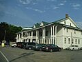
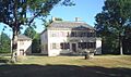
Johnson Hall is a beautiful old mansion located in Johnstown. It was built in 1763 by Sir William Johnson, a very important figure in colonial New York. He was a British official who worked closely with Native American tribes, especially the Mohawk. The house is a great example of colonial architecture and helps us understand what life was like before the American Revolution. Johnson Hall was added to the National Register in 1966 and is also a National Historic Landmark.
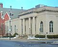
Fulton County Courthouse: A Center of Justice
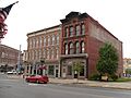
The Fulton County Courthouse in Johnstown is another significant building. It's where important legal decisions have been made for many years. Built in 1772, it's one of the oldest courthouses in New York State. Its design and history reflect the early days of American law and government. This courthouse was listed on the National Register in 1972.
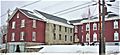
Dolge Company Factory Complex: Industrial History
In Dolgeville, you'll find the Dolge Company Factory Complex. This complex of buildings tells the story of early American industry. It was once a bustling factory that produced felt and piano parts. The factory played a big role in the town's growth and economy. It was added to the National Register in 1974, reminding us of the hard work and innovation that shaped the region.
Gloversville Free Library: A Place for Knowledge
The Gloversville Free Library is a beautiful building in Gloversville that has served as a center for learning and community for a long time. Libraries are important because they provide access to books and information, helping people learn and grow. This library was recognized for its historical value and listed on the National Register in 1976.
Kane Mountain Fire Observation Station: Watching Over the Wilds
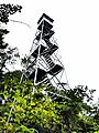
High up on Kane Mountain in Caroga, there's the Kane Mountain Fire Observation Station. This fire tower was built to help spot forest fires, protecting the vast wilderness of the Adirondacks. It's a reminder of the efforts made to preserve our natural environment and the dangers of wildfires. This unique structure was added to the National Register in 2001.
Northville Historic District: A Village's Story
The Northville Historic District includes a whole area of buildings in the village of Northville. This district is special because it shows how a small Adirondack town developed over time. Walking through it, you can see different styles of architecture and imagine what life was like in the past. It was listed on the National Register in 2014.
Other Notable Historic Places
Fulton County has many other places on the National Register that are worth knowing about:
- Benjamin Chamberlain House (Johnstown): A historic home listed in 1999.
- Downtown Gloversville Historic District (Gloversville): An area with many historic buildings in the heart of the city, listed in 1985.
- First United Methodist Church (Gloversville): A church recognized for its architecture and history, listed in 1998.
- Fulton County Jail (Johnstown): An old jail building with historical significance, listed in 1981.
- Gloversville Armory (Gloversville): A former military building, listed in 1995.
- Hotel Broadalbin (Broadalbin): A historic hotel, listed in 2011.
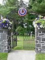
- Johnstown Colonial Cemetery (Johnstown): An old cemetery where many early settlers are buried, listed in 1998.
- Kingsboro Historic District (Gloversville): Another historic area in Gloversville, listed in 1975.
- Knox Mansion (Johnstown): A grand historic house, listed in 2008.
- Gustav Levor House (Gloversville): A historic residence, listed in 2005.
- Log Cabin Church (Johnstown): A unique church building, listed in 1999.
- Oliver Rice House (Mayfield): An old house with historical ties, listed in 1995.
- Oppenheim and St. Johnsville Union Society Church (Crum Creek vicinity): A historic church, listed in 2010.
- Sacandaga Railroad Station (Sacadaga Park): An old train station, listed in 2003.
- Godfrey Shew House (Fish House): A historic home, listed in 2006.
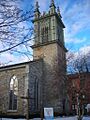
- St. John's Episcopal Church (Johnstown): A historic church, listed in 2004.
- US Post Office-Johnstown (Johnstown): The historic post office building, listed in 1989.
These sites help us understand the rich history of Fulton County, from its early settlements to its industrial growth and community life. Visiting them can be like taking a step back in time!
Images for kids
-
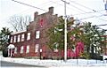
The Benjamin Chamberlain House in Johnstown.
-
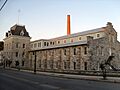
The Dolge Company Factory Complex in Dolgeville.
-
A street view of the Downtown Gloversville Historic District.
-
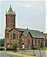
The First United Methodist Church in Gloversville.
-
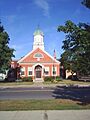
The Fulton County Courthouse in Johnstown.
-
The Fulton County Jail in Johnstown.
-

Image for a site with a restricted address.
-
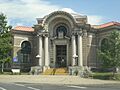
The Gloversville Free Library.
-
The Hotel Broadalbin.
-
Johnson Hall State Historic Site.
-
The Johnstown Colonial Cemetery.
-
The Kane Mountain Fire Observation Station.
-
Image for a site with a restricted address.
-

A view of the Northville Historic District.
-
Image for a site with a restricted address.
-
St. John's Episcopal Church in Johnstown.
-
The US Post Office in Johnstown.


