
National Register of Historic Places listings in Green County, Kentucky facts for kids

Have you ever wondered about old buildings and places that tell a story? In Green County, Kentucky, there are many special spots that are part of something called the National Register of Historic Places. This is like a special list kept by the United States government. It helps protect important buildings, sites, and objects that have a big meaning in history.
When a place is on this list, it means it's worth saving for future generations. It could be a very old house, a unique bridge, or even a whole part of a town! These places help us learn about how people lived long ago and what events shaped our world. Green County is proud to have 46 different properties and areas on this important list. Let's explore some of them!
Contents
What is the National Register of Historic Places?
The National Register of Historic Places is the official list of the nation's historic places. It is part of a program to coordinate and support public and private efforts to identify, evaluate, and protect America's historic and archaeological resources. Think of it as a way to celebrate and keep safe the places that matter most to our country's past.
Why are these places important?
These historic places are like giant history books. They show us how people built things, what their lives were like, and what important events happened there. By protecting them, we make sure that these stories don't get lost. It's a way to connect with the past and understand where we come from.
Historic Gems in Green County
Green County has many fascinating places on the National Register. Let's look at a few examples, especially those in the main town of Greensburg, Kentucky.
Greensburg's Downtown History
The heart of Greensburg, especially around the Public Square, is a Downtown Greensburg Historic District. This means that many buildings in this area are old and important. It's like stepping back in time when you walk through these streets!
- Old Courthouse: Right in the Public Square, you'll find the Old Courthouse. It was built a long time ago, in 1804. This building was where important decisions were made for the county. It's one of the oldest courthouses still standing in Kentucky!
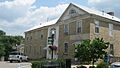
- Greensburg Bank Building: Also on East Court Street, the Greensburg Bank Building is another historic spot. It shows us what banks looked like in the past.
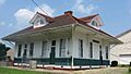
- James Allen's Inn: This old inn on East Court Street was a place where travelers could stay. Imagine people stopping here after a long journey!
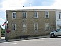
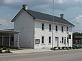
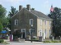
- Green County Court Clerk's Office: Near the courthouse, this office also has a long history. It's where important records for the county were kept.
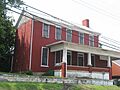
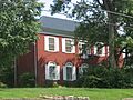
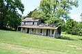
- Federal House: Located at South Main and East Columbia, the Federal House is a beautiful old home. It shows the style of houses built a long time ago.
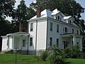
- William H. Herndon House: This house on South Main Street is another example of the historic homes in Greensburg.
- William Hobson House: You can find this historic house on South Depot Street.
- Woodson Lewis House: This house on Main Street and Hodgenville Avenue is also a part of Greensburg's rich history.
- White-Penick House: Another historic home on South Depot Street.
- R.H. Wilson House: This house on North Water Street adds to the collection of historic buildings in Greensburg.
- Greensburg Academy: Located on 2nd Street, the Greensburg Academy was an important school in the past. It helped educate many young people in the area.
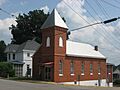
- Greensburg Cumberland Presbyterian Church: This church on Hodgenville Avenue and North 1st Street is a historic place of worship.
- L & N Passenger Depot: On North Depot Street, this old train station was once a busy place where people arrived and departed by train.
- Mud Brick House in Greensburg: This unique house on Campbellsville Road is special because of how it was built, using mud bricks!
- Goose Creek Foot Bridge: This bridge connects Court and Depot Streets. It's a pedestrian bridge, meaning it was made for people to walk across.
Other Historic Places in Green County
Beyond Greensburg, other towns and areas in Green County also have important historic sites:
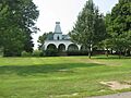
- Christopher Columbus Christie House: Located in Haskingsville, Kentucky, this house is another example of a historic home in the county.
- Elijah Creel House: This house on East Columbia Avenue is another historic building.
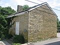
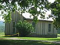
- Whitlock Log Cabin: Found in Exie, Kentucky, this log cabin gives us a peek into how people lived in simpler, earlier times.
These are just a few of the many amazing places in Green County that are recognized for their historical value. Each one tells a part of the story of this area and its people.
Images for kids
-
James Allen's Inn
-
Christopher Columbus Christie House
-
Green County Court Clerk's Office
-

Elijah Creel House
-
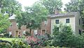
Old Stone Row in Greensburg, part of the Downtown Greensburg Historic District
-
Federal House
-
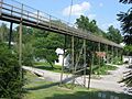
Goose Creek Foot Bridge
-
Greensburg Academy
-
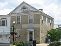
Greensburg Bank Building
-
Greensburg Cumberland Presbyterian Church
-
William H. Herndon House
-

William Hobson House
-
Keltner House site
-
L & N Passenger Depot
-
Woodson Lewis House
-
Mud Brick House in Greensburg
-
Old Green County Courthouse
-
White-Penick House
-
Whitlock Log Cabin
-

R.H. Wilson House


