
National Register of Historic Places listings in Greene County, Alabama facts for kids

Greene County, Alabama, is a place with a rich history! Many of its old buildings and special places are so important that they've been added to a list called the National Register of Historic Places. This list helps protect and celebrate amazing spots across the United States.
Think of it like a Hall of Fame for historic buildings, homes, and areas. When a place is on this list, it means it's recognized for its unique history, architecture, or connection to important events. Greene County has 35 such special places! These special spots are located in towns like Eutaw, Boligee, and Forkland.
Contents
Historic Homes and Plantations
Greene County is home to many beautiful old houses and plantations, each with its own story. These buildings often show off different styles of architecture from the past.
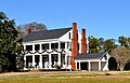
Everhope Plantation

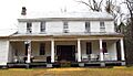
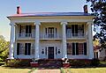
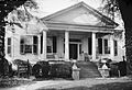
The Capt. Nathan Carpenter House, also known as Everhope Plantation, is a grand home built in 1852. It's located southeast of Clinton, near Eutaw. This house is a great example of the Greek Revival style, which was popular in the 1800s. Greek Revival buildings often have tall columns and look like ancient Greek temples.
Boligee Hill

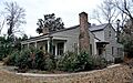
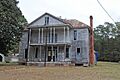
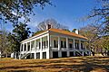
Boligee Hill is another historic home found southeast of Boligee. It was added to the National Register in 1982. Like many old homes in the area, it tells a story about the people who lived there long ago and the way life used to be.
Kirkwood

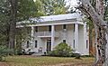
In Eutaw, you can find Kirkwood, a beautiful house located on Kirkwood Drive. This home was recognized for its historical importance in 1976. It stands as a reminder of the past, showing the architectural styles and ways of living from earlier times in Alabama.
Rosemount and Thornhill

Near Forkland, there are two more notable plantations: Rosemount and Thornhill. Rosemount, located northwest of Forkland, was listed in 1971. Thornhill, also northwest of Forkland, followed in 1984. These plantations are important because they represent the history of the region and the architectural styles of their time.
Important Public Buildings and Districts
Not all historic places are homes. Some are public buildings or entire areas that have historical significance.
Greene County Courthouse

The Greene County Courthouse is a very important building in Eutaw. It's located right on Courthouse Square. This courthouse was built a long time ago and has been the center of local government and community life for many years. It was added to the National Register in 1971.
Greene County Courthouse Square District

The area around the courthouse is also very special! The Greene County Courthouse Square District includes the courthouse and the buildings around it. This entire district was recognized in 1979 because it shows how towns were laid out and how people lived and worked in the past. It's a great example of a historic town center.
First Presbyterian Church

The First Presbyterian Church in Eutaw is another significant building. It stands at the corner of Main Street and Wilson Avenue. Churches often play a big role in a community's history, and this one was listed on the National Register in 1974, showing its importance to the area.
St. John's-In-The-Prairie

Near Forkland, you can find St. John's-In-The-Prairie. This historic church was added to the National Register in 1975. It's a beautiful example of early church architecture and a place where people have gathered for worship and community events for many generations.
Other Notable Listings
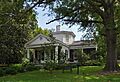
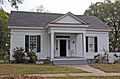
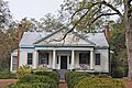
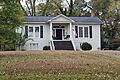
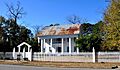
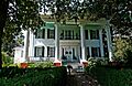
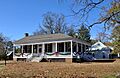
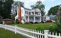
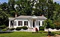
Many other homes and buildings in Greene County are also on the National Register, showing the rich history of the area. Some of these include:
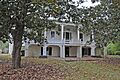
- The Gustave Braune House in Eutaw.
- The Samuel W. Cockrell House in Eutaw.
- The John Coleman House in Eutaw.
- The Coleman-Banks House in Eutaw.
- The Attoway R. Davis Home in Eutaw.
- The Rev. John H. Gray House in Eutaw.
- The Stephen Fowler Hale House in Eutaw.
- The William C. Jones House in Eutaw.
- The Dr. Willis Meriwether House in Eutaw.
- The William Perkins House in Eutaw.
- The William F. Pierce House in Eutaw.
- The Littleberry Pippen House in Eutaw.
- The Edwin Reese House in Eutaw.
- The Phillip Schoppert House in Eutaw.
- The Iredell P. Vaughn House in Eutaw.
- The William Peter Webb House in Eutaw.
- The Asa White House in Eutaw.
- The William B. Wills House in Eutaw.
- The Catlin Wilson House in Eutaw.
- The Daniel R. Wright House in Eutaw.
Some of these historic places, like the David Rinehart Anthony House and the Benjamin D. Gullett House, are no longer standing, but their sites are still recognized for their past importance. The John W. Elliott House was moved from its original spot, but it remains a part of this important historical list.
Images for kids
-
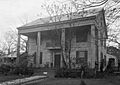
The David Rinehart Anthony House, now destroyed.
-
The Gustave Braune House.
-
The Samuel W. Cockrell House.
-
The John Coleman House, also known as Grassdale.
-
The Coleman-Banks House.
-
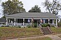
The Attoway R. Davis Home.
-
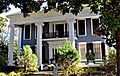
Glenville, a historic home in Eutaw.
-
The Rev. John H. Gray House.
-
The Stephen Fowler Hale House.
-
The William C. Jones House.
-
The Dr. Willis Meriwether House.
-
The William Perkins House.
-
The William F. Pierce House.
-
The Littleberry Pippen House.
-
The Edwin Reese House.
-

The William A. Rogers House.
-
The Phillip Schoppert House.
-
The Iredell P. Vaughn House.
-
The William Peter Webb House.
-
The Asa White House.
-
The William B. Wills House.
-
The Catlin Wilson House.
-
The Daniel R. Wright House.


.jpg)


