
National Register of Historic Places listings in Greene County, North Carolina facts for kids

Greene County, North Carolina, is home to many amazing places that tell stories about the past! These special spots are listed on the National Register of Historic Places. This is like a national "Hall of Fame" for buildings, sites, and objects that are important to American history. When a place is on this list, it means it's recognized for its unique history and is often protected so future generations can learn from it.
Contents
Discovering Greene County's History
Imagine stepping back in time! That's what visiting a historic place can feel like. In Greene County, many buildings and sites have been around for a long time. They show us how people lived, worked, and built communities years ago. Protecting these places helps us understand our local and national history better. It's like having a giant history book you can walk through!
Famous Historic Spots
Greene County has several fascinating places on the National Register. Each one has its own special story.
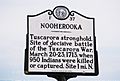
Fort Neoheroka
One very important site is Fort Neoheroka. This was a fort used during the Tuscarora War in the early 1700s. It was a major battleground between the Tuscarora Native Americans and colonial forces. Today, it's a powerful reminder of this important time in North Carolina's history. It helps us remember the conflicts and changes that shaped the region long ago.
Greene County Courthouse
The Greene County Courthouse in Snow Hill is another key historic building. Courthouses are often the heart of a county's government and community life. This building has seen many important decisions made and events unfold over the years. It stands as a symbol of justice and local governance in Greene County.
Snow Hill Colored High School
The Snow Hill Colored High School also in Snow Hill, holds a significant place in history. This school was built during a time when schools were separated by race. It played a vital role in providing education for African American students in the area. It represents the struggles and triumphs in the fight for equal education.
Historic Homes and Buildings
Many old homes and other buildings in Greene County are also on the list. For example, the Benjamin W. Best House and the Titus W. Carr House are beautiful examples of older architecture. They show us how homes were designed and built many years ago. The Edward R. and Sallie Ann Coward House and the Hardee House are also historic homes that tell stories of the families who lived there. These houses give us a glimpse into daily life from long ago.
The St. Barnabas Episcopal Church in Snow Hill is another historic building. Churches often serve as important community centers and have beautiful architecture. The Zachariah School is an old school building that reminds us of how education used to be.
Why These Places Matter
These historic places are more than just old buildings or sites. They are clues to the past, helping us understand where we came from. By preserving them, we make sure that future generations can also learn from these stories. It's important to protect these treasures so their history can continue to teach and inspire us all.
Images for kids
-
A historical marker for Fort Neoheroka, noting its significance.

