
National Register of Historic Places listings in Haines Borough, Alaska facts for kids

Welcome to Haines Borough, Alaska! This special place is home to several important historical sites. These sites are so important that they are listed on the National Register of Historic Places. This list helps protect and celebrate places that tell us about America's past. Think of it like a hall of fame for buildings, structures, and areas that have a big story to tell.
There are 6 places in Haines Borough on this special list. One of them is even more important and is called a National Historic Landmark. Let's explore some of these cool historical spots!
Contents
What is the National Register of Historic Places?
The National Register of Historic Places is the official list of the United States' historic places worth saving. It's like a national treasure map, pointing out buildings, sites, and objects that are important to history. When a place is on this list, it means it has a unique story about our country's past. This could be about how people lived, important events, or special ways buildings were made.
Historic Places in Haines Borough
Let's take a closer look at some of the amazing historical sites you can find in Haines Borough:
Charlie Anway Cabin
The Charlie Anway Cabin is a historic cabin located about 1.5 miles down the Haines Highway from Haines. It was added to the National Register on September 14, 2001. This cabin gives us a peek into how people lived in Alaska a long time ago. It shows the simple, tough life of early settlers.
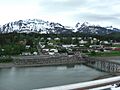
Eldred Rock Lighthouse
The Eldred Rock Lighthouse is a beautiful lighthouse found south of Haines, near Sullivan Island. It was listed on the National Register on December 30, 1975. Lighthouses are like guardians of the sea, guiding ships safely through the waters. The Eldred Rock Lighthouse has been doing this important job for many years, helping sailors navigate the tricky Alaskan coastline.

Fort William H. Seward
Fort William H. Seward is a very important place, located south of Haines at Port Chilkoot. It became a National Historic Landmark on April 11, 1972. This means it's one of the most significant historical sites in the entire country! It was originally a military fort, built to help protect the area. Today, it's a reminder of Alaska's military history and how communities grew around these important outposts.

Government Indian School
The Government Indian School is located on 1st Street in Haines. It was added to the National Register on February 8, 1980. This building tells a part of the story of education for Native American children in the past. It's a place that helps us remember and learn about the history of schooling in the region.
Pleasant Camp
Pleasant Camp, also known as the Dalton Trail Camp, is found about 40 miles northwest of Haines on the Haines Highway. It was listed on the National Register on July 5, 1973. This camp was once a busy spot for the Northwest Mounted Police in the late 1800s. Imagine police officers and travelers stopping here during their journeys! It was an important resting and supply point along the old Dalton Trail.
_IN_LATE_1920s_-_Dalton_Trail_Post,_Mile_40,_Haines_Highway,_Haines,_Ha_-_LOC_-_hhh.ak0001.photos.001415p.jpg)
Porcupine District
The Porcupine District is an area located west of Haines, around Mile 35 on the Haines Highway. It became a historic district on November 13, 1976. This area was a mining camp that was very active in the early 1900s. People came here hoping to find valuable minerals. The Porcupine District helps us remember the exciting, and sometimes tough, history of mining in Alaska.

Images for kids
-

The historic Eldred Rock Lighthouse
-
Fort William H. Seward, a National Historic Landmark
-
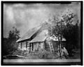
The main building at Dalton Cache, part of Pleasant Camp, in the late 1920s.
-
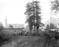
Porcupine Camp in 1910, showing the mining activity in the district.
