
National Register of Historic Places listings in Hertford County, North Carolina facts for kids

Hertford County, North Carolina, is home to many amazing places that tell stories from the past! These special spots are listed on the National Register of Historic Places. This is like a national list of important buildings, districts, and sites that are worth protecting because of their history, architecture, or what happened there. When a place is on this list, it means it's recognized as a valuable part of America's heritage.
You can find all sorts of historic places in Hertford County, from old schools and grand houses to entire neighborhoods that look much like they did many years ago. Exploring these sites helps us understand how people lived, worked, and built communities long ago.
Contents
What is the National Register of Historic Places?
The National Register of Historic Places is the official list of the United States' historic places that are considered worthy of preservation. It's managed by the National Park Service. Getting on this list means a place has been carefully studied and found to be important to local, state, or national history.
Being on the National Register doesn't stop people from changing a property, but it does encourage owners to preserve its historic features. It can also help them get grants or tax benefits for restoration work. These places are like time capsules, showing us what life was like in different eras.
Exploring Historic Places in Ahoskie
Ahoskie has several areas and buildings that are recognized for their historical importance. These places help us remember the town's growth and its community life.
Historic Districts in Ahoskie
- The Ahoskie Downtown Historic District was added to the list in 1985. It covers the main business area of Ahoskie, showing how the town center developed over time.
- The Ahoskie Historic District was listed in 2012. This larger area includes many homes and buildings that show the town's history beyond just the downtown shops.
- The East End Historic District in Ahoskie was added in 2008. It's another neighborhood that has kept its historic look and feel.
Old Schools and Homes in Ahoskie
- The Ahoskie School was built a long time ago and became a historic site in 2005. It's a reminder of how education has changed in the area.
- The Roberts H. Jernigan House is a historic home listed in 2001. It gives us a peek into the lives of families who lived in Ahoskie.
- The King-Casper-Ward-Bazemore House is another important house, added in 1982. It's located just west of Ahoskie.
- The William Mitchell House was listed in 1972 and is found east of Ahoskie.
- Mulberry Grove is a historic property southwest of Ahoskie, added in 1980.
- The James Newsome House was listed in 1984 and is located near Ahoskie.
Discovering Murfreesboro's Past
Murfreesboro is another town in Hertford County with a rich history, featuring many beautiful old homes and a historic downtown.
Murfreesboro Historic District
- The Murfreesboro Historic District was recognized in 1971. This district includes a large part of the town, with many buildings that show its long history. Walking through it is like stepping back in time.
Grand Homes of Murfreesboro
- The David A. Barnes House was added to the list in 2014. It's a significant home in Murfreesboro.
- The Cedars is a historic property southeast of Murfreesboro, listed in 1983.
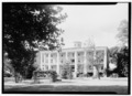
- The Columns is another impressive home, recognized in 1971. It's known for its grand design.
- The Cowper-Thompson House was added in 1992.
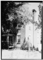
- The Freeman House was listed in 1971.
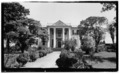
- Melrose is a historic house added in 1971.
- The Myrick House was listed in 1971.
- The Myrick-Yeates-Vaughan House was added in 1983.
- The Roberts-Vaughan House was listed in 1971.
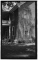
- The John Wheeler House was recognized in 1971.
Other Historic Sites in Murfreesboro
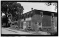
- The William Rea Store was listed in 1970. This old store building shows what commerce was like in Murfreesboro many years ago.
Historic Spots in Winton and Como
Winton and Como also have their own unique historic places that are part of the National Register.
Winton's Historic Buildings
- The C. S. Brown School Auditorium in Winton was listed in 1985. This building is important for its role in education and community events.
- Gray Gables is a historic home on Main Street in Winton, added in 1982.
- The King Parker House was listed in 2002.
Como's Historic Sites
- The Hare Plantation House was added in 1971 and is located west of Como.
- The Mill Neck School was listed in 2016, showing its importance to the community's educational history.
- The Riddick House was recognized in 1971.
- Vernon Place is another historic property north of Como, added in 1982.
Other Important Historic Sites
Hertford County has a few more special places that are listed on the National Register, each with its own story.
- The Wiley and Jane Vann Brown House is located near Union and was listed in 2007.
- The Deane House near Cofield was added in 1982.
- The Harrellsville Historic District was listed in 1995, preserving the historic character of this town.
- The Pleasant Plains School was added in 2016. It's located south of the junction with Pleasant Plains Road.
- The Dr. Roscius P. and Mary Mitchell Thomas House and Outbuildings near Bethlehem were listed in 2007.
Images for kids
-
The Columns in Murfreesboro.
-
The Freeman House in Murfreesboro.
-
Melrose in Murfreesboro.
-
The William Rea Store in Murfreesboro.
-
The John Wheeler House in Murfreesboro.
