
National Register of Historic Places listings in Hidalgo County, Texas facts for kids

This article is about the cool and important places in Hidalgo County, Texas that are listed on the National Register of Historic Places. This special list is like a hall of fame for buildings, areas, and objects that are important to American history, architecture, archaeology, engineering, or culture. When a place is on this list, it means it's recognized for its unique story and is often protected so future generations can enjoy it too!
Hidalgo County is in the southern part of Texas, right near the border with Mexico. It has a rich history, and many of its old buildings and sites tell stories about the people who lived there and the events that shaped the area. Let's explore some of these amazing historic places!
Contents
Historic Places in Hidalgo County
Here are some of the interesting places in Hidalgo County that have been added to the National Register of Historic Places. Each one has a special story to tell.
Mission
Mission is a city in Hidalgo County with several historic spots.
- Border Theater
This theater, built in 1941, was a popular place for movies and shows. It's a great example of the Art Deco style, which was very popular back then. Imagine watching a movie here decades ago!
- La Lomita Historic District
This area includes the historic La Lomita Chapel, which was built in 1899. It's a very old and important religious site that served early settlers in the region. It's a peaceful place that shows how people lived and worshipped long ago.
- Lomita Boulevard Commercial Historic District
This district covers several blocks of North Conway Boulevard. It shows what a busy shopping and business area looked like in Mission during the early 20th century. Many of the buildings here have kept their original look.
- Mission Canal Company Second Lift Pumphouse
This old pumphouse, built in 1907, was part of a big system that brought water from the Rio Grande River to farms in the area. It helped turn dry land into rich farmland, which was super important for the growth of Hidalgo County.
- Mission Citrus Growers Union Packing Shed
Built in 1926, this shed was where citrus fruits like oranges and grapefruits were prepared for shipping. The citrus industry was a huge part of Mission's economy, and this building reminds us of that important history.
- Oblate Park Historic District
This district includes homes and buildings that show how Mission grew in the early 1900s. It gives us a peek into the daily lives and community spirit of the people who lived there.
- Roosevelt School Auditorium and Classroom Addition
This school building, completed in 1927, was an important place for education in Mission. It shows the architecture of schools from that time and reminds us how much schools have changed over the years.
- Teatro La Paz
This theater, built in 1946, was a cultural center for the community. It hosted plays, concerts, and other events, bringing entertainment and art to the people of Mission.
McAllen
McAllen is another major city in Hidalgo County with its own unique historic places.
- Casa de Palmas
This beautiful hotel, built in 1918, is known for its Spanish Colonial Revival style. It's a landmark in McAllen and has hosted many important guests over the years.
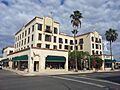
- Cine El Rey
Opened in 1942, this movie theater was a popular spot for entertainment. Its design is a mix of Art Deco and Spanish Colonial styles, making it a very cool building to look at.
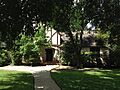
- Mary S. and Gordon Griffin House
This house, built in 1939, is a great example of the Mid-Century Modern style of architecture. It shows how homes were designed in the middle of the 20th century.
- M and J Nelson Building
This commercial building, constructed in 1927, is a good example of early 20th-century architecture in downtown McAllen. It shows the kind of businesses that thrived in the city's early days.
- Sam and Marjorie Miller House
Built in 1939, this house is another example of the architectural styles popular in McAllen during that time. It represents the homes of prominent families in the community.
Hidalgo
The city of Hidalgo also has some very old and significant buildings.
- Louisiana-Rio Grande Canal Company Irrigation System
This system, which includes pump stations and canals, was built starting in 1907. It was a huge project that brought water from the Rio Grande to irrigate thousands of acres of land, making farming possible in the area. The first pump station is in Hidalgo.
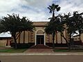
- Old Hidalgo Courthouse and Buildings
These buildings, dating back to 1886, served as the county courthouse for many years. They are important because they represent the early government and justice system in Hidalgo County.
- Old Hidalgo School
Built in 1909, this school building is a historic landmark. It shows the early efforts to provide education in the region and how school buildings looked over a hundred years ago.
Other Areas in Hidalgo County
Hidalgo County also has historic sites outside of its main cities.
- Cortez Hotel (Weslaco)
Located in Weslaco, this hotel was built in 1928. It's a grand building that shows the growth and development of towns in the Rio Grande Valley during the early 20th century.
- El Sal Del Rey Archeological District (Linn)
This district near Linn is an archaeological site. It's important because it contains evidence of ancient human activity, giving us clues about the very first people who lived in this area.
- McAllen Ranch (Linn)
This historic ranch near Linn has been around for a long time, showing the history of ranching and land use in Hidalgo County. It represents the traditional way of life in rural Texas.
- Rancho Toluca (Progreso)
Located near Progreso, Rancho Toluca is another historic ranch. It tells the story of early settlements and agricultural practices in the region.
- Valley Fruit Company (Pharr)
In Pharr, this building, constructed in 1929, was part of the important fruit packing industry in the area. It highlights the agricultural heritage of the Rio Grande Valley.
Images for kids
-

The historic Border Theater in Mission.
-
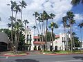
The beautiful Casa de Palmas hotel in McAllen.
-

Cine El Rey, a historic movie theater in McAllen.
-
The Cortez Hotel in Weslaco.
-

The Mary S. and Gordon Griffin House in McAllen.
-
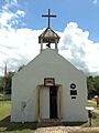
The historic La Lomita Chapel near Mission.
-
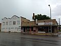
Buildings in the Lomita Boulevard Commercial Historic District.
-

The First Pump Station of the Louisiana-Rio Grande Canal Company Irrigation System in Hidalgo.
-

The M and J Nelson Building in McAllen.
-
The Sam and Marjorie Miller House in McAllen.
-

The Mission Canal Company Second Lift Pumphouse.
-

The Mission Citrus Growers Union Packing Shed.
-

A building within the Oblate Park Historic District.
-

The Old Hidalgo Courthouse.
-

The Old Hidalgo School.
-
The Roosevelt School Auditorium and Classroom Addition.
-

Teatro La Paz in Mission.
-
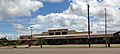
The Valley Fruit Company building in Pharr.


