
National Register of Historic Places listings in Iowa County, Wisconsin facts for kids

Welcome to Iowa County, Wisconsin! This special place is home to many historic sites and buildings. These locations are so important that they are listed on the National Register of Historic Places. This list helps protect and celebrate places that tell us about the past. In Iowa County, there are 40 different properties and areas that have earned this special recognition.

Contents
Historic Homes and Buildings
Many of Iowa County's historic places are old homes and important buildings. They show us how people lived and worked long ago.
Homes with a Story
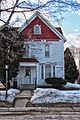
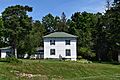
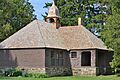
- William Henry Brisbane House: Built in 1868, this house in Arena has a unique Gothic Revival style. It belonged to William Henry Brisbane, who was once a slave owner in South Carolina. But he later became a famous abolitionist, fighting to end slavery.
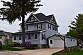
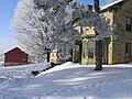
- Cassidy Farmhouse: This two-story house in Barneveld was built in 1860. Its walls are made from local limestone. Henry and Sarah Cassidy were among the first people to settle in Barneveld.
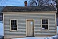
- Dodge Mining Camp Cabin: Located in Dodgeville, this log cabin was built in 1827. It might have been built by Henry Dodge, who led some of the first groups looking for lead in the area. It was later updated with wooden siding in the 1840s.
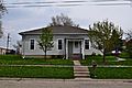
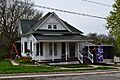
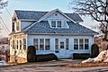
- Harris House: This Queen Anne style home in Barneveld was built around 1890. The owner of the local lumberyard built it. He hoped to rent rooms to people visiting a nearby mineral spring.
- Ihm House: Also in Barneveld, this fancy Queen Anne cottage was built around 1891. Fred Lampop, who owned a stable and farm machine business, built it.
- David J. and Maggie Jones House: This Italianate style house in Dodgeville was built in 1878. It was first owned by J.C. Hocking, a miner and businessman from Cornwall. Later, David J. Jones, a Welsh immigrant and Civil War veteran, lived there.
- Kittleson House: This American Foursquare house in Barneveld was built in 1911. It has pretty decorative shingles in its dormers. William Dagenhardt, who owned a warehouse, built it.
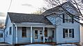
- Roethlisberger House: This house in Barneveld was likely built in the 1880s. It features Queen Anne style windows and decorative shingles.
Important Public Buildings
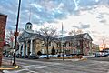
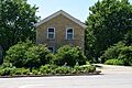
- Iowa County Courthouse: Located in Dodgeville, this courthouse was built in 1859. It has a grand Greek Revival style. It was built using local limestone by skilled stoneworkers from Cornwall. This is the oldest courthouse in Wisconsin that has been used continuously!
- Linden High School: This two-story brick high school in Linden was built in 1913. It was designed in the German Renaissance Revival style. At the time, zinc mining was very popular in Linden. The school had grades 1-8 on the first floor and high school on the second. It was taken down in 1996.
- Old Rock School: This two-story school in Dodgeville was built in 1853. It was made of limestone by Thomas Carkeek, an immigrant from Cornwall. It was one of Dodgeville's first permanent schools. Later, it became a home and was restored around 1970.
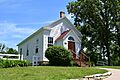
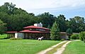
- Wyoming Valley School: Designed by famous architect Frank Lloyd Wright, this two-room school was built in 1957. It's in the valley where Wright spent his summers as a boy. Today, it's a local cultural center.
Historic Districts
- Grove Street Historic District: This area in Barneveld includes six modest homes and their landscaping. These homes survived the terrible Barneveld tornado of 1984. They show us what Barneveld looked like before the storm.
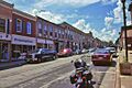
- Iowa Street Historic District: This is Dodgeville's old downtown area. It includes the 1859 Greek Revival Iowa County Courthouse. Other buildings include an 1888 Italianate hardware store, a 1901 Queen Anne opera house, and a 1919 Neoclassical bank. There's also a 1922 Craftsman harness shop and a 1940 Art Deco telephone company building.
- Mineral Point Historic District: This historic part of Mineral Point is Wisconsin's third oldest city. It includes limestone cottages built by Cornish lead miners in the 1830s and 40s. You can also see the 1838 Greek Revival Odd Fellows Hall and the 1845 Gothic Revival Trinity Episcopal church.
Churches and Chapels
Iowa County has several beautiful historic churches. They reflect the different communities and their beliefs.
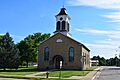
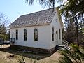
- Hyde Chapel: This wooden Greek Revival style church in Ridgeway was built in 1862. English and Welsh settlers built it. The nearby cemetery has burials that are even older than the church itself.
- Linden Methodist Church: This limestone-block church in Linden was built in 1851. Cornish masons built it for the Methodist congregation. Later, a balcony and a steeple were added.
- Plum Grove Primitive Methodist Church: This small Gothic Revival style church in Ridgeway was built in 1882. It was built by a group of Methodists who had a disagreement about whether an organ should be used in the choir. It became a community hall in 1934.
- Pulaski Presbyterian Church Complex: This wooden Gothic Revival style church in Pulaski was built in 1874. It replaced an older log church. The complex also includes a wooden schoolhouse built in 1901.
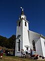
- Unity Chapel: Located south of Spring Green, this Shingle style chapel was built in 1886. It was designed by Joseph Lyman Silsbee, with help from his student Frank Lloyd Wright. It was built for Wright's uncle, Jenkin Lloyd Jones, who was a Unitarian minister.
Mining History Sites
Iowa County has a rich history of lead and zinc mining. Several sites tell the story of this important industry.
- Mineral Point Hill: This hill in Mineral Point was where most of the city's lead was mined between 1830 and 1855. It was also the site of the Merry Christmas zinc mine, which opened around 1906.
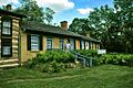
- Pendarvis: In Mineral Point, Pendarvis is a collection of three cottages. Early lead miners built them from local limestone in the 1840s. The name "Pendarvis" comes from one of the cottages, which looks like a traditional Cornish home. These cottages were restored starting in 1935 and are now a historical museum.
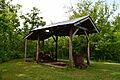
- Shot Tower: Located southeast of Spring Green in Tower Hill State Park, this is a reconstructed shot tower from 1831. Here, lead mined from the region was turned into lead shot, which was used for hunting.
- Spensley Farm: This farm in Mineral Point was the center of operations for James Spensley, a British immigrant. It includes the site of his lead-smelting furnace and his Italianate style limestone house built in the 1850s. He also bred cattle here.
Frank Lloyd Wright's Legacy
Iowa County is home to some very important sites connected to the famous architect Frank Lloyd Wright.
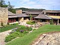
- Taliesin: Located south of Spring Green, Taliesin is the home, studio, and farm complex of Frank Lloyd Wright. He started building it in 1911. It was rebuilt and changed many times after fires and as Wright developed new ideas. The complex includes Wright's home, the Hillside Home School (1902), Midway Farms (1938), and the Romeo and Juliet Windmill (1896).
Other Notable Sites
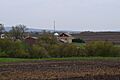
- Thomas Stone Barn: This large stone barn in Brigham was built around 1881 for Walter Thomas, a Welshman. It has tall limestone walls and a gable roof. It was first used for sheltering animals and hay, and later for dairy farming.
Images for kids
-

Archeological Site No. 47Ia167
-
Archeological Site No. 47Ia168
-
William Henry Brisbane House
-
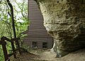
Carden Rockshelter
-
Cassidy Farmhouse
-
DNR No. 4 Rockshelter
-
DNR No. 5 Archeological Site
-
Dodge Mining Camp Cabin
-
Gottschall Site (47Ia80)
-
Grove Street Historic District
-
Harris House
-
Hole-in-the-Wall No. 1 Cave
-
Hyde Chapel
-
Ihm House
-
Iowa County Courthouse
-

Iowa Street Historic District
-
David J. and Maggie Jones House
-
Kittleson House
-
Linden High School
-
Linden Methodist Church
-
Mayland Cave
-
McCoy Rock Art Site
-
Mineral Point Hill
-
Mineral Point Historic District
-
Old Rock School
-
Pendarvis
-
Plum Grove Primitive Methodist Church
-
Pulaski Presbyterian Church Complex
-
Rainbow Cave
-
Roberts House
-
Roethlisberger House
-
Sawle Mound Group Archeological District
-
Shiprock Rockshelter
-
Shot Tower
-
Spensley Farm
-
Taliesin
-
Thomas Stone Barn
-
Unity Chapel
-
Wyoming Valley School


