
National Register of Historic Places listings in Jefferson County, New York facts for kids

Welcome to Jefferson County, New York! This page is all about the amazing historic places here that are listed on the National Register of Historic Places. Think of this register as a special list of buildings, sites, and objects that are important to American history, architecture, archaeology, engineering, or culture. When a place is on this list, it means it's recognized for its unique story and value.
You can even see many of these places on a map if you click on "Map of all coordinates" (though some locations are kept secret to protect them). Let's explore some of these cool spots!
Contents
What is the National Register of Historic Places?
The National Register of Historic Places is like a hall of fame for important historical sites across the United States. It's managed by the National Park Service. When a place is added to this list, it helps protect it and makes people more aware of its history. It's not just about old buildings; it can be anything from a battlefield to a lighthouse, or even a whole neighborhood!
Historic Homes and Buildings
Jefferson County has many old homes and buildings that tell stories of the past.
Grand Mansions and Houses
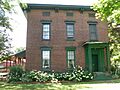
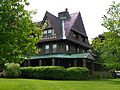
- The William Archer House in Brownville is one of several historic stone houses in the area. Imagine living in a house built so long ago!
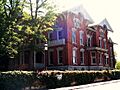
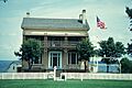
- The Gen. Jacob Brown Mansion, also in Brownville, was the home of a famous general. It's part of a group of stone houses that are all very old and special.
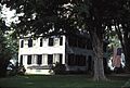
- The Elisha Camp House in Sackets Harbor is another important historic home. These houses give us a peek into how people lived many years ago.
- The Roswell P. Flower Memorial Library in Watertown is a beautiful building. It's not just a place for books; it's a piece of history itself!
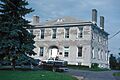
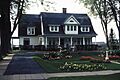
- The Paddock Mansion in Watertown is another grand home. These mansions often belonged to important people in the community and show us the styles of the past.
- The Emma Flower Taylor Mansion in Watertown is also on the list. It's named after a notable person and adds to the rich history of the city.
Unique Structures
- The George C. Boldt Yacht House near Alexandria Bay is super cool! It was designed by famous architects and is part of the amazing Boldt Castle estate. Imagine having a giant boathouse for your yacht!
- The Duvillard Mill in Cape Vincent is an old mill. Mills were very important long ago for grinding grain and other tasks.
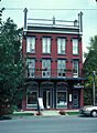
- The LeRay Hotel in Evans Mills and the Brownville Hotel were important gathering places in their towns. Hotels were often central to community life.
- The Paddock Arcade in Watertown is a special kind of building with shops and businesses inside, all under one roof. It's one of the oldest shopping arcades in the country!
- The Watertown Masonic Temple is a historic building used by the Masons, a fraternal organization.
Important Public Places
Some places on the list are not just buildings, but entire areas or public spaces.
Historic Districts
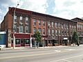
- The Adams Commercial Historic District includes old shops and buildings in the center of Adams village. These districts show how towns used to look and function.
- The Broadway Historic District in Cape Vincent and the Chaumont Historic District are also special areas. Walking through them is like stepping back in time!
- The Clayton Historic District and the Sackets Harbor Village Historic District are other examples of historic neighborhoods. They help preserve the unique character of these towns.
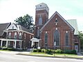
- The Public Square Historic District in Watertown is a very important central area. It's where many historic buildings and activities have taken place over the years.
- The State Street Historic District in Carthage also preserves a part of the town's past.
- The Thousand Island Park Historic District on Wellesley Island is a beautiful area known for its Victorian-era homes and unique community feel.
- The Three Mile Bay Historic District and the Village of Antwerp Historic District also highlight important historical parts of their communities.
Churches and Schools
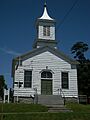
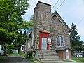
- The Dexter Universalist Church and the East Hounsfield Christian Church are examples of historic churches. Churches often served as important community centers.
- The Church of Saint Lawrence in Alexandria Bay and St. Paul's Church in Brownville are also on the list.
- The Buttermilk Flat Schoolhouse No. 22 and Carter Street Schoolhouse No. 21 were old one-room schoolhouses. Imagine learning in a classroom where all ages were together!
- The Grenadier Island Schoolhouse and Grindstone Island Upper Schoolhouse show how education reached even the islands.
- The Stone Mills Union Church is another historic church in the area.
Lighthouses and Battlefields
Jefferson County is home to important lighthouses and a significant battlefield.
Guiding Lights
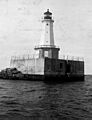
- The East Charity Shoal Light is a lighthouse in Lake Ontario. Lighthouses were crucial for guiding ships safely.
- The Galloo Island Light and Rock Island Light Station are other lighthouses in the area. They stand as symbols of maritime history.
- The Tibbetts Point Light is a well-known lighthouse at the tip of a peninsula, marking the entrance to the St. Lawrence River.
Historic Battlefields
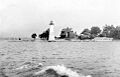
- The Sackets Harbor Battlefield State Historic Site is a very important place. It was the site of two battles during the War of 1812. This is where American soldiers fought to protect their land. It's a great place to learn about military history.
- Fort Haldimand Site on Carleton Island is another historic military site, though its exact location is kept private.
Other Interesting Sites
- The Cedar Grove Cemetery in Chaumont is a historic cemetery. Cemeteries can tell us a lot about the people who lived in an area and how they lived.
- The Conklin Farm and Stevenson-Frink Farm are examples of historic farms. Farms were the backbone of early American life.
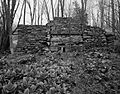
- The LeRaysville Archeological District and Sterlingville Archeological District are places where archaeologists study the past by digging up artifacts. These sites are often kept secret to protect them.
- The Storrs' Harbor Naval Shipyard Site is another restricted site, likely where old ships were built or repaired.
- The Talcott Falls Site and Swarthout Site are also archaeological sites, giving clues about ancient cultures.
- The Wood's Grist Mill is an old mill that processed grain.
These are just some of the many fascinating places in Jefferson County that are recognized for their historical importance. Each one has a unique story to tell about the past!
Images for kids
-
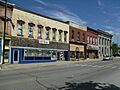
Adams Commercial Historic District
-
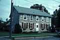
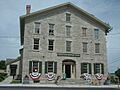
William Archer House
-
Bedford Creek Bridge
-
Dr. Abner Benton House
-
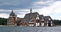
George C. Boldt Yacht House
-
Gen. Jacob Brown Mansion
-
E. K. Burnham House
-
Elisha Camp House
-
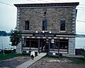
Cornwall Brothers' Store
-
Dexter Universalist Church
-
East Charity Shoal Light
-
First Baptist Church and Cook Memorial Building
-
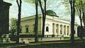
Roswell P. Flower Memorial Library
-

Fort Haldimand Site (Address Restricted)
-
Galloo Island Light
-
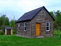
Grenadier Island Schoolhouse
-
Dr. Samuel Guthrie House
-
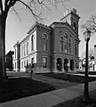
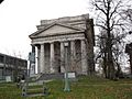
Jefferson County Courthouse Complex
-
Vincent LeRay House
-
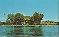
Longue Vue Island
-
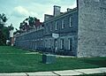
Madison Barracks
-
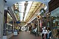
Paddock Arcade
-
Paddock Mansion
-
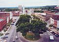
Public Square Historic District
-
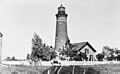
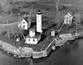
Rock Island Light Station
-
Cornelius Sacket House
-
Sackets Harbor Battlefield
-
Sackets Harbor Village Historic District
-
Smith-Ripley House
-
State Street Historic District
-
Sterlingville Archeological District (Address Restricted)
-
Emma Flower Taylor Mansion
-
Thomas Memorial AME Zion Church
-
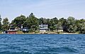
Thousand Island Park Historic District
-
Tibbetts Point Light
-
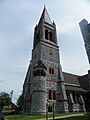
Trinity Episcopal Church and Parish House
-
Union Hotel
-
Watertown Masonic Temple
-
Wood's Grist Mill


_Schoolhouse.jpg)

.jpg)


.jpg)


