
National Register of Historic Places listings in Joshua Tree National Park facts for kids
Joshua Tree National Park is a special place in California, United States, known for its unique desert plants and amazing rock formations. But did you know it's also home to some very important historical sites? These places are so important that they are listed on the National Register of Historic Places.
The National Register of Historic Places is like a special list kept by the U.S. government. It helps protect buildings, sites, and objects that are important to American history, architecture, archaeology, engineering, or culture. When a place is on this list, it means it's recognized as a valuable part of our past.
In Joshua Tree National Park, there are six places that have made it onto this special list. They tell stories about the people who lived and worked in this desert environment long ago, from early settlers and ranchers to miners. Let's explore these historic spots!
Contents
Historic Places in Joshua Tree National Park
These six sites in Joshua Tree National Park are recognized for their historical importance. They show us how people lived and used the desert land in the past.
Barker Dam
Barker Dam is an old concrete dam built in the desert. It was first built by ranchers in 1902 to collect water for their cattle. Later, in 1949, it was made taller by William F. Keys, a famous local rancher.
This dam was super important because water is very scarce in the desert. It helped support ranching and mining activities in the area by providing a reliable water source. Today, it's a popular spot for visitors to see desert wildlife, especially birds, that come to drink from the water.
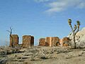
Cow Camp
Cow Camp is a historic site that shows us what life was like for cowboys and ranchers in the early 1900s. It was a base for cattle operations in the desert. Ranchers would bring their cows here to graze.
The camp includes a small cabin and other structures. These buildings were used by the cowboys who looked after the cattle. It helps us understand the challenges and daily life of ranching in the harsh desert environment.
Desert Queen Mine
The Desert Queen Mine is an old gold mine located deep within the park. It was one of the most successful gold mines in the Joshua Tree area. The mine started operating in the late 1800s.
It was owned by different people over the years, including the famous desert character, Bill Keys. The mine shows how people tried to find wealth in the desert. You can still see some of the old mining equipment and structures there today.
Keys Desert Queen Ranch
The Keys Desert Queen Ranch is one of the most famous historic sites in the park. It was the home and workplace of William F. Keys and his family for over 60 years. Bill Keys was a very resourceful man who made a living in the desert.
He built his ranch from scratch, using materials he found or recycled. The ranch includes his home, a schoolhouse, workshops, and other buildings. It's a great example of how people adapted to life in the desert. The ranch is now a museum that you can visit on a guided tour.
Ryan House and Lost Horse Well
This site includes the remains of the Ryan House and the Lost Horse Well. It was part of a larger mining and ranching operation. The Ryan family lived here and worked in the nearby mines.
The Lost Horse Well was a crucial water source for both people and animals. Like Barker Dam, it highlights how important water was for survival and development in the desert. The ruins of the house and the well tell a story of early settlers trying to make a life in this challenging landscape.
Wall Street Mill
The Wall Street Mill is an old mill used to process gold ore from nearby mines, including the Desert Queen Mine. It was built by Bill Keys in the 1930s. The mill used a powerful engine to crush rocks and extract gold.
This mill was very important for the mining industry in the area. It allowed miners to process their ore more efficiently. Today, you can see the remains of the mill, including the machinery and structures, which show the ingenuity of early desert inhabitants.
Images for kids
-
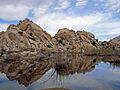
Barker Dam, built to collect water for ranching.
-
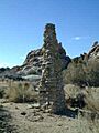
The chimney at Cow Camp, a historic ranching site.
-
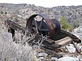
Old mining equipment at the Desert Queen Mine.
-
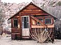
A guest house at the historic Keys Desert Queen Ranch.
-
The ruins of the Ryan Ranch House.
-
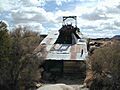
The Wall Street Mill, used to process gold ore.


