
National Register of Historic Places listings in southern Puerto Rico facts for kids

This article is a list of cool old buildings and areas in the southern parts of Puerto Rico. These places are special because they are listed on the National Register of Historic Places (which is called Registro Nacional de Lugares Históricos in Spanish). This list includes spots along the southern coast of the island and on the southern side of Puerto Rico's central mountain range.
The places covered stretch from the town of Yauco on the southwest coast all the way to the Guayama area in the southeast.
See also:
- National Register of Historic Places listings in Puerto Rico
- National Register of Historic Places listings in northern Puerto Rico
- National Register of Historic Places listings in western Puerto Rico
- National Register of Historic Places listings in central Puerto Rico
- National Register of Historic Places listings in eastern Puerto Rico
- National Register of Historic Places listings in San Juan, Puerto Rico
Contents
Guayama
Here are some historic places in Guayama:
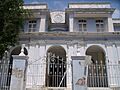
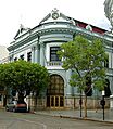
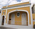
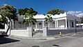
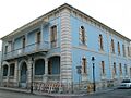
- Casa Cautiño: This beautiful building from 1887 is designed in a style called Classical Revival.
- Cayey Bridge: An old iron bridge built in 1891. It crosses the Río Guamaní on Highway 15.
- Eleuterio Derkes Grammar School: A Neo-Classical school building from 1909.
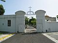
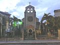
- Iglesia Parroquial de San Antonio de Padua de Guayama: This church was built way back in 1775.
- Ingenio Azucarero Vives: This was a sugar mill, an important part of the island's history.
Guayanilla
Here's a historic place in Guayanilla:
- Padre Nazario School: An elementary school named after José M. Nazario. He discovered the Nazario Collection, which is a group of important historical items.
Juana Díaz
Here are some historic places in Juana Díaz:
- Church San Juan Bautista y San Ramón Nonato of Juana Diaz: This church was built in 1807.
- Cueva Lucero: This is a prehistoric site with ancient rock art. It's a cool look into the past!
Peñuelas
Here's a historic place in Peñuelas:
- Daniel Webster School: An old school building located on Luis Muñoz Rivera Street.
Ponce
Ponce has many historic buildings! Here are some of them:
Historic Buildings in Ponce
- Albergue Caritativo Tricoche: This hospital was built in 1885 in the Neoclásico Isabelino style.
- Antiguo Cuartel Militar Español de Ponce: This was the Spanish military headquarters in Ponce, built in 1894.
- Antiguo Hospital Militar Español de Ponce: Another Spanish military building, this hospital was built in 1897.
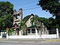
- Armstrong-Toro House: A beautiful Neoclassical house designed by Manuel Domenech in 1899.
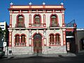
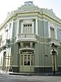
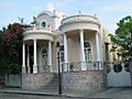
- Banco Crédito y Ahorro Ponceño: This bank building was designed in the Beaux Arts style by Francisco Porrata Doria in 1924.
- Banco de Ponce: Also designed by Francisco Porrata Doria in 1924, this is another Beaux Arts style bank building.
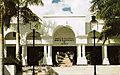
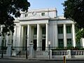
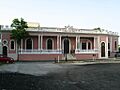
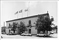
- Casa Alcaldía de Ponce – City Hall: Ponce's City Hall was built in 1846 in the Neoclásico Isabelino style.
- Casa de la Masacre: This house was the headquarters for the Puerto Rican Nationalist Party in the 1930s. It was the site of the Ponce massacre in 1937. Today, it's a museum.
- Casa Miguel C. Godreau: A house built in 1919, designed by Julio Conesa.
- Casa Paoli: This was the childhood home of Antonio Paoli, a famous opera singer from Puerto Rico.
- Casino de Ponce: A grand building from 1922, designed by Agustin Camilo Gonzalez. It combines Second Empire and Neo-Rococo styles.
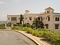
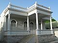
- Castillo de Serralles: This "castle" was built in 1926 in the Spanish Mediterranean style.
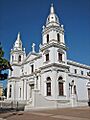
- Catedral Nuestra Señora de Guadalupe of Ponce: The main cathedral in Ponce, built in 1835.
- Cementerio Antiguo de Ponce: An old cemetery from 1842, enlarged in 1864.
- Cementerio Catolico San Vicente de Paul: Also known as Cementerio Católico de Ponce, this cemetery dates back to 1901.
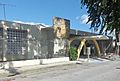
- Edificio Empresas Ferré: A historic building located in the Playa area of Ponce.
- Edificio Municipal de la Playa de Ponce: Another municipal building in the Playa area.
- Font–Ubides House: This house from 1913 features Classical Revival and Art Nouveau styles.
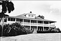
- Hacienda Buena Vista: A Colonial-style coffee plantation from 1833. It's a great example of old Puerto Rican farms.
- Iglesia de la Santísima Trinidad: This church from 1926 combines Late Gothic Revival and Mission/Spanish Revival styles.
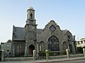
- McCabe Memorial Church: A Neo-gothic church built in 1908, designed by Antonin Nechodoma.
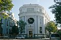
- Mercado de las Carnes: This Art Deco meat market was built in 1926.
- Missionary Society of the Methodist Episcopal Church: A unique building from 1907 that mixes several architectural styles.
- Oppenheimer House: A Spanish-Art Nouveau house from 1913.
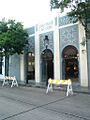
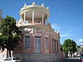
- Parque de Bombas de Ponce: This famous fire station was built in 1882 in a Gothic style. It's a landmark in Ponce!
- Ponce High School: A Classical Revival school building from 1915.
- Ponce YMCA Building: The YMCA building in Ponce, listed as part of a larger historic submission.
- Rosaly–Batiz House: An Italian Renaissance Palazzo-style house from 1897.
- Salazar–Candal House: This house from 1911 combines Neo-Classic, Art Nouveau, and Spanish Revival styles.
- Subirá House: A Ponce Creole style house from 1910.
- Fernando Luis Toro Casa: A large house from 1927 that blends many architectural styles, including Victorian and Modernism.
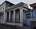
- U.S. Custom House (Ponce, Puerto Rico): This Spanish colonial building from 1842 was once the customs house.
- Villaronga House: A Classical Revival house from 1921.
- Zaldo de Nebot Residencia: A Classical Revival building from 1895.
Historic Sites in Ponce
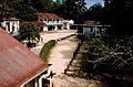
- Centro Ceremonial Indígena: Also known as Tibes Indigenous Ceremonial Center, this is an ancient site where the native Taíno people held ceremonies.
- Faro de la Isla de Caja de Muertos: A Neo-classical lighthouse built in 1887 on Caja de Muertos Island.
- Faro del Puerto de Ponce: Another Neo-classical lighthouse from 1889, located on Isla Cardona in Ponce Harbor.
- Puente Río Portugués: A bridge spanning the historic channel of Río Portugués.
Salinas
Here's a historic place in Salinas:
- Central Aguirre Historic District: This area dates back to 1899 and was once a large sugar cane plantation and community.
Santa Isabel
Here are some historic places in Santa Isabel:
- Dr. Martin G. Brumbaugh Graded School: A historic school building in Santa Isabel Pueblo.
- Sistema de riego de las tres haciendas: This is a historic irrigation system that helped water three large farms.
Yauco
Here are some historic places in Yauco:
- Casa Agostini: A Classical Revival house designed by Miguel Briganti Pinti.
- Casa Franceschi Antongiorgi: A Beaux Arts style house from 1907.
- Casona Césari: A house built in 1893.
- Chalet Amill: A historic chalet on Mattei Lluveras Street.
- Filardi House: This house from 1916 is famous for its amazing concrete decorations. The builders, Juan Bautista and Domingo Filardi, were experts in making these detailed designs.
- Logia Masónica Hijos de la Luz: A building from 1894.
- Residencia González Vivaldi: A Criollo style house built in 1880.
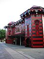
- Teatro Ideal: A historic theater on Comercio Street.
Images for kids
-
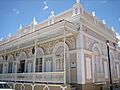
Casa Cautiño in Guayama
-
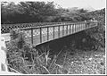
Cayey Bridge
-
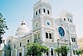
Iglesia Parroquial de San Antonio de Padua de Guayama
-
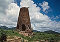
Ingenio Azucarero Vives
-
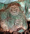
Cueva Lucero
-
Albergue Caritativo Tricoche
-
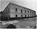
Antiguo Cuartel Militar Español de Ponce
-
Armstrong-Toro House
-
Banco Crédito y Ahorro Ponceño
-
Banco de Ponce
-
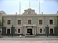
Casa Alcaldía de Ponce – City Hall
-

Casa de la Masacre
-
Casa Miguel C. Godreau
-
Casa Paoli
-
Casino de Ponce
-
Castillo de Serralles
-
Catedral Nuestra Señora de Guadalupe of Ponce
-
Cementerio Antiguo de Ponce
-
Cementerio Catolico San Vicente de Paul
-
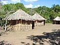
Centro Ceremonial Indígena
-
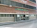
Edificio Empresas Ferré
-
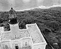
Faro de la Isla de Caja de Muertos
-
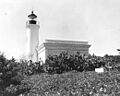
Faro del Puerto de Ponce
-
Font–Ubides House
-
Hacienda Buena Vista
-
Iglesia de la Santísima Trinidad
-
McCabe Memorial Church
-
Mercado de las Carnes
-
Missionary Society of the Methodist Episcopal Church
-
Oppenheimer House
-
Parque de Bombas de Ponce
-
Ponce High School
-
Ponce YMCA Building
-
Rosaly–Batiz House
-
Salazar–Candal House
-
Subirá House
-
Fernando Luis Toro Casa
-
U.S. Custom House (Ponce, Puerto Rico)
-
Villaronga House
-
Zaldo de Nebot Residencia
-
Central Aguirre Historic District


.jpg)


.jpg)


.jpg)
_in_Barrio_Playa_in_Ponce.jpg)


.jpg)


.png)


.jpg)

