National Register of Historic Places listings in Klamath County, Oregon facts for kids
Klamath County, Oregon, is a place filled with amazing history! Many buildings, sites, and areas here are so special that they are listed on the National Register of Historic Places. This is like a national list of important places that should be protected and remembered. It helps us learn about the past and see how people lived long ago.
Contents
Historic Buildings in Klamath Falls
Klamath Falls has many cool old buildings that tell stories of the past.
Old Hotels and Houses
- The Baldwin Hotel was built a long time ago at 31 Main Street. It became a historic spot in 1973. Imagine all the travelers who stayed there!
- The Judge Henry L. Benson House is a beautiful old home at 137 High Street. It was added to the list in 1981.
- Another old hotel, the Bisbee Hotel, stands at 229 South 6th Street. It became historic in 2006.
- The Blackburn Sanitarium was once a special hospital at 1842 Esplanade Avenue. It joined the historic list in 1996.
- The Fred Goeller House at 234 Riverside Drive was recognized in 1998. Sadly, by 2013, it needed some repairs.
- The Warren Mills House at 123 High Street was added to the list in 1993.
- The Richardson–Ulrich House at 636 Conger Avenue became historic in 1988.
- The Valley Hospital at 405 Pine Street was also listed in 1988.
Important Public Buildings
- The Klamath County Armory and Auditorium at 1451 Main Street is a big building that was listed in 2011. It's a place where many community events happened.
- The Klamath Falls City Hall at 226 South 5th Street is where the city's government works. It became historic in 1989.
- The Old Klamath Falls City Library at 500 Klamath Avenue was once the main library. It was also listed in 1989.
- The Oregon Bank Building at 905 Main Street was recognized in 1987.
Linkville Pioneer Cemetery
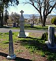
- The Linkville Pioneer Cemetery is a very old burial ground at the corner of Lexington Avenue and Upham Street. It became a historic district in 2014. It's a quiet place to remember the early settlers of Klamath Falls.
Historic Places in Crater Lake National Park
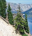
Crater Lake National Park is not just famous for its stunning lake, but also for its historic buildings!
- The Comfort Station No. 68 and Comfort Station No. 72 are historic restrooms near the Rim Village Campground. They were built a long time ago and were listed in 1988.
- The Crater Lake Lodge is a beautiful hotel right by the lake. It was built for visitors and became historic in 1981.
- The Crater Lake Superintendent's Residence is the home where the park's superintendent lived. It was built in the 1930s and is special because of its unique design and how it was built to handle the short building season at Crater Lake. It was listed in 1987.
- The Munson Valley Historic District is an area with several historic buildings in the park, including the park's administration building. It was listed in 1988.
- The Rim Drive Historic District includes the famous road that goes around Crater Lake. This whole road and the views it offers became historic in 2008.
- The Rim Village Historic District is the main visitor area at Crater Lake, with buildings like the Sinnott Memorial. It was listed in 1997.
- The Sinnott Memorial Building No. 67 is an observation station where visitors can learn about the lake. It was listed in 1988.
- The Watchman Lookout Station No. 168 is a fire lookout tower on The Watchman peak, offering amazing views. It was listed in 1988.
Other Historic Sites in Klamath County
Beyond Klamath Falls and Crater Lake, there are other cool historic spots in the county.
- The Bly Ranger Station on Highway 140 near Bly was recognized in 1981. Ranger stations are important for managing forests and helping people.
- The Fort Klamath Site is located southeast of Fort Klamath. This was once a military fort, important in the history of the area. It became historic in 1971.
- The Honeymoon Creek Snow-Survey Cabin is a small cabin in the Sky Lakes Wilderness near Ashland. It was used for measuring snow and was listed in 2000.
- The Jacksonville-to-Fort Klamath Military Wagon Road is an old road south of Butte Falls. This road was used by the military long ago and became historic in 1979.
- The Lake of the Woods Ranger Station – Work Center is in the Winema National Forest. It was listed in 1986.
- The Lower Klamath National Wildlife Refuge near Worden is a very important place for animals. It was established in 1908 and was the first large area of public land set aside to protect wildlife. It shows how people have worked to balance protecting nature with farming needs. It was listed in 1966.
- The Point Comfort Lodge at 27505 Rocky Point Road near Rocky Point was listed in 1979.
Former Historic Listings
Sometimes, a place that was once on the historic list might be removed. This happened to the Winthrow-Melhase Block in Klamath Falls, which was at 4th and Main Streets. It was listed in 1982 but removed in 1994.
Images for kids


