
National Register of Historic Places listings in LaGrange County, Indiana facts for kids

Have you ever wondered about really old and important buildings or places in your town? The National Register of Historic Places is like a special list in the United States. It helps find and protect places that are super important to history, architecture, or even what life was like long ago. When a place is on this list, it means it's recognized as a valuable part of our country's story.
This article is all about the cool historic places right here in LaGrange County, Indiana, that are on this special list. There are 8 amazing spots in our county that have been recognized for their history!
Contents
Cool Historic Places in LaGrange County
These are the places in LaGrange County that are currently on the National Register of Historic Places. Each one has a unique story!
John Badlam Howe Mansion
This grand old house is located in Lima Township, right on the grounds of the Howe Military School. It was added to the National Register on September 14, 1995. Imagine living in a house with so much history!
LaGrange County Courthouse
Found in the heart of LaGrange on Detroit Street, the LaGrange County Courthouse is a very important building. It's where many local decisions are made and has been a central part of the community for a long time. It joined the list on July 17, 1980.
Olde Store (John O'Ferrell Store)
This historic store is located in Springfield Township, at the corner of West and 2nd Streets in Mongo. It's known as the Olde Store, and it gives us a peek into what shopping and community life might have been like many years ago. It was listed on October 29, 1975.
St. James Memorial Chapel
Also in Lima Township, this beautiful chapel is on State Road 9 near Howe, just south of County Road 600 N. It's another important building found on the grounds of the Howe Military School. The chapel became a historic place on September 16, 2001.
Star Milling and Electric Company Historic District
This interesting spot is a whole historic district, not just one building! It's located northeast of Howe in Lima Township, where County Roads 505 W and 700 N meet. This area was once important for milling (grinding grain) and producing electricity. It was added to the list on September 14, 1995.
Samuel P. Williams House
You can find the Samuel P. Williams House at 101 South Street in Howe, within Lima Township. This house has been recognized for its historical value and was listed on August 11, 1980. It's a great example of the architecture from its time.
Menno Yoder Polygonal Barn
This unique barn is located west of Shipshewana in Newbury Township, at 8690 W250N. What makes it special is its "polygonal" shape, meaning it has many sides instead of being a simple rectangle. It's a cool example of old farm architecture and was added to the list on April 2, 1993.
Images for kids
-
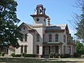
The historic John Badlam Howe Mansion.
-
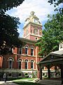
The LaGrange County Courthouse in LaGrange.
-
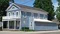
The Olde Store, also known as the John O'Ferrell Store.
-
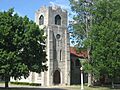
St. James Memorial Chapel.
-
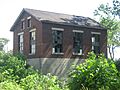
A building from the Star Milling and Electric Company Historic District.
-
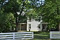
The Samuel P. Williams House in Howe.
-
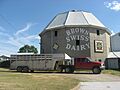
The unique Menno Yoder Polygonal Barn.


