
National Register of Historic Places listings in LaPorte County, Indiana facts for kids
The National Register of Historic Places is a special list of buildings, places, and areas in the United States that are important to history. These places are recognized for their unique architecture, historical events, or cultural significance.
In LaPorte County, Indiana, there are 34 places on this list! These include old houses, churches, lighthouses, and even entire neighborhoods. They help us remember the past and understand how people lived and worked long ago. One place was on the list but has since been removed.
When a place is on the National Register, it means it's a valuable part of our heritage. It helps protect these sites for future generations to learn from and enjoy.

Contents
- Cool Historic Places in LaPorte County
- Historic Homes and Farms
- Ames Family Homestead
- Barker House
- John H. Barker Mansion
- John and Isabel Burnham House
- Garrettson-Baine-Bartholomew House
- John and Cynthia Garwood Farmstead
- Hoover-Timme House
- Lowell E. and Paula G. Jackson House
- George and Adele Jaworowski House
- Francis H. Morrison House
- William Orr House
- Pinehurst Hall
- Scott-Rumley House
- Everel S. Smith House
- Historic Districts and Areas
- Special Buildings and Structures
- Other Notable Listings
- Historic Homes and Farms
- Former Listing
- Images for kids
Cool Historic Places in LaPorte County
Let's explore some of the interesting places in LaPorte County that are on the National Register of Historic Places.
Historic Homes and Farms
Many old homes and farms in LaPorte County have a special place in history.
Ames Family Homestead
The Ames Family Homestead is a historic farm located northwest of LaPorte. It was added to the National Register in 2012. This homestead shows us what farm life was like in the past.

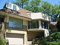
Barker House
The Barker House in Michigan City is a beautiful old home. Today, it serves as offices for the Shirley Heinze Land Trust, which works to protect natural areas. It's also near the Barker Woods Nature Preserve.
John H. Barker Mansion
Also in Michigan City, the John H. Barker Mansion is a grand building. It was listed in 1975 and now functions as the Michigan City Civic Center. Imagine the history within its walls!

John and Isabel Burnham House
This house is located in Long Beach. It was added to the list in 2013. It's a great example of the unique homes built in the area.
Garrettson-Baine-Bartholomew House
Found on Franklin Street in Michigan City, this house was recognized in 2001. It's another example of the beautiful historic homes in the city.
John and Cynthia Garwood Farmstead
This farmstead, west of LaPorte, was listed in 2012. It gives us a glimpse into the agricultural history of the county.

Hoover-Timme House
Another historic home in Long Beach, the Hoover-Timme House, was added to the Register in 2013.
Lowell E. and Paula G. Jackson House
This house in Long Beach was also listed in 2013. It's part of the rich architectural history of the area.
George and Adele Jaworowski House
Located in Duneland Beach, this house was recognized in 2013. It's a unique part of the Michigan Township area.
Francis H. Morrison House
In LaPorte, the Francis H. Morrison House was added in 1984. It's a significant part of LaPorte's historic homes.
William Orr House
West of LaPorte, the William Orr House was listed in 1984. It's another example of the historic farmhouses in Center Township.
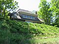
Pinehurst Hall
Northwest of LaPorte, Pinehurst Hall was added to the Register in 1976. It's a notable building with a long history.
Scott-Rumley House
The Scott-Rumley House in LaPorte was listed in 2016. It's one of the more recently added historic homes.
Everel S. Smith House
In Westville, the Everel S. Smith House was recognized in 1990. It's an important part of Westville's heritage.

Historic Districts and Areas
Some entire areas or neighborhoods are recognized for their historical importance.
Downtown LaPorte Historic District
This district covers the downtown area of LaPorte. It includes many historic buildings roughly bounded by State, Jackson, Maple, and Chicago Streets. It was listed in 1983.

Elston Grove Historic District
In Michigan City, the Elston Grove Historic District is a historic neighborhood. It's bounded by Michigan Boulevard and 11th, Pine, and 6th Streets. It was added in 2013.
Franklin Street Commercial Historic District
This district in Michigan City includes many historic commercial buildings on Franklin Street. It's bounded by Pine, 4th, and 11th Streets, and an alley. It was listed in 2013.

Haskell and Barker Historic District
Another Michigan City district, this one covers Washington and Wabash between 4th and Homer Streets. It was added in 2014.
Indiana and Michigan Avenues Historic District
This district in LaPorte includes areas around Indiana and Michigan Avenues. It was listed in 2014 and features historic buildings like the LaPorte Carnegie Library.

Washington Park
Washington Park in Michigan City is a large historic area. It's roughly bounded by Lake Michigan, Krueger Street, Trail Creek, and other roads. It was recognized in 1991.

Special Buildings and Structures
LaPorte County also has unique buildings and structures on the Register.
First Congregational Church of Michigan City
This beautiful church on Washington Street in Michigan City was listed in 2001. It's an important part of the city's religious and architectural history.

Michigan City East Pierhead Light Tower and Elevated Walk
This lighthouse stands on the eastern side of the entrance to Michigan City Harbor. It was added to the Register in 1988 and is a key landmark.

Michigan City Lighthouse
Also known as the Old Michigan City Light, this lighthouse is located in Washington Park. It was listed in 1974 and is a popular historical site.

Michigan City Post Office
The old Michigan City Post Office building on East 5th Street was listed in 2000. In 2010, it was being used as a law office, showing how historic buildings can find new uses.

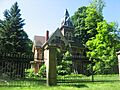
Pinhook Methodist Church and Cemetery
Northeast of Westville, this church and its cemetery on State Road 2 were added to the Register in 2009. It's a place with deep community roots.

Marion Ridgeway Polygonal Barn
This unique barn is located north of LaPorte on U.S. Route 35. It's called "polygonal" because it has many sides, not just four! It was listed in 1993.

Other Notable Listings
MUSKEGON Shipwreck Site
Yes, even shipwrecks can be historic! The MUSKEGON Shipwreck Site near Michigan City was added to the Register in 1989. Its exact location is kept secret to protect it.

Former Listing
Sometimes, a place is removed from the National Register. This can happen if the building is destroyed or changes too much.
Michigan Central Railroad Engine Repair Shops
The Michigan Central Railroad Engine Repair Shops in Michigan City were listed in 1975 but removed in 1978. This means the building either no longer exists or lost its historical features.
Images for kids
-
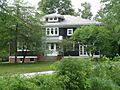
The Barker House in Michigan City.
-
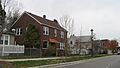
A street view in the Elston Grove Historic District.
-
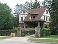
The Garrettson-Baine-Bartholomew House.
-
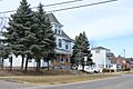
A street in the Haskell and Barker Historic District.
-
The Hoover-Timme House in Long Beach.
-

The Lowell E. and Paula G. Jackson House.
-
The George and Adele Jaworowski House.
-
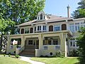
The Francis H. Morrison House in LaPorte.
-
The William Orr House.
-
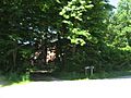
Pinehurst Hall seen through trees.


