
National Register of Historic Places listings in Lee County, South Carolina facts for kids

Have you ever wondered about old buildings and places that are super important to history? In Lee County, South Carolina, there's a special list of these places called the National Register of Historic Places. This list helps protect buildings, sites, and objects that have a lot of history and meaning for our country.
When a place is on this list, it means it's recognized as a significant part of American history. It could be an old house, a school, a church, or even a whole neighborhood! Being on the Register encourages people to preserve these places so future generations can learn from them. In Lee County, there are 17 different places currently on this important list. One place was on the list but has since been removed.
Contents
Discovering Lee County's Historic Places
Lee County is home to many fascinating historic sites. These places tell stories about how people lived, worked, and built communities long ago. They are like real-life history books you can visit!
Historic Buildings in Bishopville
Many of Lee County's historic spots are found in the town of Bishopville. This includes several beautiful old homes and important public buildings.
Homes with History
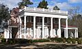
- The James Carnes House is an old home in Bishopville that has been recognized for its historical value. It's a great example of the kind of homes people built in the past.
- Another interesting house is the William Apollos James House. Imagine the families who lived here and the stories these walls could tell!
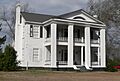
- The Manor is a grand old house that also made it onto the list. It shows us the different styles of architecture that were popular many years ago.
- The William Rogers House and the Spencer House are two more historic homes in Bishopville. Each one has its own unique look and history.
- Tall Oaks is another historic property in Bishopville, recognized for its importance.
Important Community Buildings
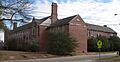
- The Ashwood School Gymnasium and Auditorium is a cool old building that was once part of a school. Gyms and auditoriums are where students gathered for sports, plays, and important events.
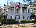
- Dennis High School is another former school building that is now a historic site. Schools are often central to a community's history.
- The Lee County Courthouse was built in 1908 and designed by a famous architect named William Augustus Edwards. Courthouses are very important buildings where laws are made and justice is served.
Historic Districts and Churches
Besides individual buildings, sometimes whole areas are considered historic. These are called historic districts.
Bishopville's Historic Areas
- The Bishopville Commercial Historic District includes a part of N. Main Street and Cedar Lane. This area was once the bustling center of business in Bishopville. It's fun to imagine what it was like when these streets were filled with horse-drawn carriages and early cars!
- The South Main Historic District is another area in Bishopville recognized for its historic buildings. Walking through these districts is like taking a step back in time.
Old Churches with Stories
- The Lynchburg Presbyterian Church is an old church located near South Lynchburg. Churches often play a big role in the history of a community.
- Mt. Zion Presbyterian Church is another historic church in Bishopville.
- Rembert Church is located near Woodrow.
- St. Philip's Episcopal Church, Bradford Springs is found near Dalzell. These churches show the long history of faith and community in Lee County.
Other Notable Historic Places
- The Thomas Fraser House is another historic home in the area.
- Tanglewood Plantation is a historic plantation located southeast of Lynchburg. Plantations are large farms that often have very old and important buildings.
What Happens When a Place is Removed?
Sometimes, a place that was once on the National Register of Historic Places might be removed. This usually happens if the building is torn down or changed so much that it no longer looks like it did historically.
Bishopville High School
- Bishopville High School was once on the list. It was located at 600 N. Main Street in Bishopville. However, the main part of the school was torn down in 2016. Because of this, it was removed from the National Register of Historic Places. Only the gymnasium and some other buildings added later are still there.
Images for kids
-
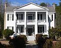
The historic James Carnes House in Bishopville.
-
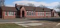
The old Dennis High School building.
-
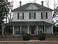
The William Apollos James House.
-
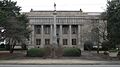
The Lee County Courthouse, built in 1908.
-
The historic Manor house.
-
The William Rogers House.
-
The Spencer House.
-
The former Bishopville High School, before it was mostly torn down.
_2.JPG)
_2.JPG)


_1.JPG)
_3.JPG)
_2.JPG)

