
National Register of Historic Places listings in Linn County, Kansas facts for kids

Have you ever wondered about the oldest and most important places in your community? In Linn County, Kansas, there are several special spots that are officially recognized for their history! This list tells you about the places in Linn County that are on the National Register of Historic Places.
The National Register of Historic Places is like a special list kept by the United States government. It helps protect buildings, sites, and objects that are important to American history, architecture, archaeology, engineering, or culture. When a place is added to this list, it means it's a valuable part of our past that should be preserved for future generations.
In Linn County, there are 8 different places that have earned a spot on this important list. Each one has a unique story to tell about the history of Kansas and the United States.
Historic Places in Linn County
Here are some of the amazing historic places you can find in Linn County:
Battle of Mine Creek Site
The Battle of Mine Creek Site is located southwest of Pleasanton. This area was the scene of a major battle during the American Civil War. It was added to the National Register of Historic Places on December 12, 1973. This battle was one of the largest cavalry battles of the Civil War fought in Kansas.
Landers Creek Bridge
The Landers Creek Bridge is found at the southern edge of Goodrich. This bridge is an example of older engineering and how people used to build ways to cross rivers and creeks. It became a historic place on July 2, 1985.
Linn County Courthouse
The Linn County Courthouse is a very important building in Mound City. It's located at 4th and Main streets. Courthouses are often central to a county's history, where many important decisions and events have taken place. This courthouse was added to the National Register on July 15, 1974.
Marais des Cygnes Massacre Site
The Marais des Cygnes Massacre Site is a very significant historical location northeast of Trading Post. This site remembers a sad event from before the Civil War, known as the Marais des Cygnes Massacre. It includes the Hadsell House, which was built by the famous abolitionist John Brown to help protect people. This site was recognized as historic on June 21, 1971.
Mine Creek Bridge
Another historic bridge in Linn County is the Mine Creek Bridge, found east of Mound City. Like the Landers Creek Bridge, this structure shows us how people built important connections across the landscape long ago. It was added to the National Register of Historic Places on March 10, 1983.
Old Linn County Jail
The Old Linn County Jail is also in Mound City, at 312 Main Street. Old jails can tell us a lot about how laws were enforced and how communities were organized in the past. This building became a historic site on November 30, 1978.
Prescott School
The Prescott School is located at 3rd and Main Streets in Prescott. School buildings often hold many memories and stories about education and community life over the years. This school was added to the National Register on May 6, 1982.
Prescott Rural High School
Also in Prescott, the Prescott Rural High School is at 202 West 4th Street. This high school is another example of an important educational building from the past. It was recognized as a historic place on July 3, 2008, as part of a larger effort to list historic public schools in Kansas.
Images for kids
-
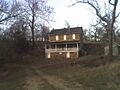
The Hadsell House at the Marais des Cygnes Massacre Site.

