
National Register of Historic Places listings in Macon County, North Carolina facts for kids

Did you know that many special buildings, places, and even old village sites in Macon County, North Carolina, are protected because of their history? These important spots are listed on something called the National Register of Historic Places. This is like a special list kept by the United States government to make sure these places are remembered and taken care of for future generations.
When a place is added to this list, it means it has a unique story or shows us something important about the past. It could be an old house where famous people lived, a church with beautiful architecture, or even a very old Native American village site. Let's explore some of these amazing historic treasures right here in Macon County!
Contents
Exploring Macon County's Historic Treasures
Macon County is full of interesting places that tell us about the past. From old homes to historic churches and even ancient sites, each one has a story.
Homes with History
Many of the buildings on the National Register are old homes. These houses give us a peek into how people lived many years ago.
Baldwin-Coker Cottage
The Baldwin-Coker Cottage is a charming old house located in Highlands, North Carolina. It was added to the historic list on May 9, 2003. Imagine what life was like in this cottage over a hundred years ago!

Albert Swain Bryson House
Another interesting home is the Albert Swain Bryson House in Franklin, North Carolina. This house, added on December 20, 1984, stands as a reminder of the people who shaped the community long ago.

Cabin Ben
Also in Highlands, North Carolina, you can find Cabin Ben. This unique cabin was recognized for its history on April 22, 2003. It's fun to think about the families who might have lived here and the stories they shared.

Important Buildings
Beyond homes, many other types of buildings are also considered historic. These often include places where communities gathered, like churches and hotels.
Churches with Rich Past
Churches often play a big role in a town's history. Macon County has several historic churches.
The Church of the Incarnation in Highlands, North Carolina, was added to the list on May 16, 1996. It's a beautiful building that has served its community for many years.

In Franklin, North Carolina, you'll find the Franklin Presbyterian Church, listed on February 5, 1987. The Saint Agnes Episcopal Church, also in Franklin, joined the list on June 4, 1987. These churches show us the different styles of building from the past and how communities grew.


Grand Old Hotels
Hotels were once central gathering places for travelers and locals.
The Edwards Hotel in Highlands, North Carolina, became historic on November 20, 1992. Imagine people arriving by horse and buggy to stay here!

Another notable hotel is the Franklin Terrace Hotel in Franklin, North Carolina, listed on July 29, 1982. These old hotels remind us of a time when travel was very different.

Ancient Sites and Districts
Some historic places are not just buildings but entire areas or very old sites that tell us about ancient times.
Cowee Mound and Village Site
The Cowee Mound and Village Site near West's Mill, NC is a very important historical spot. It was added to the National Register on January 18, 1973. This site was once a bustling village and mound built by Native Americans, showing us how people lived long before modern towns existed. Because of its importance, its exact address is kept secret to protect it.
Nikwasi
Nikwasi is another incredibly important Native American site located in Franklin, North Carolina. It was listed on November 26, 1980. This site, also known as Site 31MA1, is a significant part of Cherokee history and culture. It was once a major Cherokee town and a place of great importance for their people.

Historic Districts
Sometimes, a whole group of buildings or an area is considered historic. These are called "historic districts."
The Cowee-West's Mill Historic District and the Highlands North Historic District are examples of these. These districts include many buildings that together create a picture of how these areas developed over time. The Playmore-Bowery Road Historic District and the Satulah Mountain Historic District in Highlands also preserve the unique character of those neighborhoods.
These historic places help us understand the past and appreciate the rich heritage of Macon County, North Carolina.
Images for kids
-
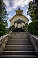
The First Presbyterian Church in Highlands.
-
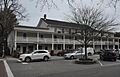
The Highlands Inn.
-
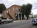
The Pendergrass Building in Franklin.


