
National Register of Historic Places listings in McCracken County, Kentucky facts for kids

Welcome to McCracken County, Kentucky! This area is full of amazing old buildings and places that are super important to history. These special spots are listed on something called the National Register of Historic Places. It's like a hall of fame for buildings and areas that tell a big part of America's story.
In McCracken County, there are 32 different places and areas that have made it onto this important list. Each one has a unique history, from old homes to churches and even a school. Let's explore some of these cool historic sites!
Contents
- Historic Homes and Famous People
- Important Public Buildings and Structures
- Market House: A Community Hub
- Grace Episcopal Church: A Place of Worship
- Hotel Irvin Cobb: A Grand Old Hotel
- Hotel Metropolitan: A Landmark for Travelers
- Masonic Temple: A Historic Meeting Place
- People's First National Bank and Trust Company Building
- St. Francis DeSales Roman Catholic Church
- Augusta Tilghman High School: An Important School Building
- Union Station School: A School for Change
- Historic Districts: Entire Neighborhoods with History
- Other Notable Historic Sites
- Images for kids
Historic Homes and Famous People
Many of the places on the National Register are old homes, some of which belonged to famous people.
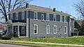
The Angles: Home of a Vice President
Imagine living in a house that once belonged to a Vice President of the United States! That's the story of The Angles. This house was the home of Alben W. Barkley, who was Vice President from 1949 to 1953. It's located on Alben W. Barkley Drive, which is named after him.
- Address: Alben W. Barkley Dr. near 40th St., Paducah
- Listed: July 19, 1976
Anderson-Smith House: A Unique Welcome Center
The Anderson-Smith House is another special home. Today, it's known as Whitehaven and serves as Kentucky's welcome center for visitors. It's the only historic house in the entire United States that's used as a state welcome center! Inside, you can even see furniture that belonged to Vice President Alben Barkley.
- Address: Lone Oak Rd., Paducah
- Listed: March 1, 1984
Tilghman-Woolfolk House: A Historic Residence
The Tilghman-Woolfolk House is another beautiful old home in Paducah. It has been recognized for its historical importance.
- Address: 631 Kentucky Ave., Paducah
- Listed: August 13, 1998
Mayor David A. Yeiser House
The Mayor David A. Yeiser House was once the home of Paducah's Mayor David A. Yeiser. It's a great example of the historic homes in the area.
- Address: 533 Madison St., Paducah
- Listed: March 7, 1973
Important Public Buildings and Structures
Beyond homes, many public buildings and structures are also listed for their historical value.
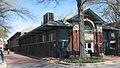
Market House: A Community Hub
The Market House in Paducah has been a central gathering place for a very long time. Markets are places where people buy and sell goods, and this building played a big role in the community's daily life.
- Address: S. 2nd St. between Broadway and Kentucky Ave., Paducah
- Listed: June 19, 1973
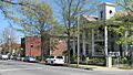
Grace Episcopal Church: A Place of Worship
The Grace Episcopal Church is a beautiful historic church in Paducah. Churches often have long histories and are important parts of a community's heritage.
- Address: 820 Broadway, Paducah
- Listed: March 16, 1976
Hotel Irvin Cobb: A Grand Old Hotel
The Hotel Irvin Cobb was once a grand hotel, a place where travelers and important guests would stay. Old hotels often have amazing architecture and stories from the past.
- Address: Broadway and 6th St., Paducah
- Listed: August 24, 1978
Hotel Metropolitan: A Landmark for Travelers
The Hotel Metropolitan is another significant hotel. It played an important role, especially for African American travelers during a time when many places were segregated. It offered a safe and welcoming place to stay.
- Address: 724 Oscar Cross Ave., Paducah
- Listed: April 12, 2002
Masonic Temple: A Historic Meeting Place
The Masonic Temple is a building used by the Masons, a fraternal organization. These buildings often have unique designs and serve as important community centers.
- Address: 501-505 S. 7th St., Paducah
- Listed: December 4, 2002
People's First National Bank and Trust Company Building
This building housed a major bank, showing the economic history and growth of Paducah. Banks are often built to look strong and important, reflecting their role in the community.
- Address: 300 Broadway, Paducah
- Listed: August 11, 1980
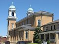
St. Francis DeSales Roman Catholic Church
Another beautiful church on the list, the St. Francis DeSales Roman Catholic Church is recognized for its historical and architectural value.
- Address: 116 S. 6th St., Paducah
- Listed: April 16, 1979
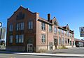
Augusta Tilghman High School: An Important School Building
The Augusta Tilghman High School building served as a place of learning for many years. Schools are vital to a community's development and history.
- Address: 401 Walter Jetton Boulevard, Paducah
- Listed: April 3, 1995
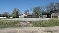
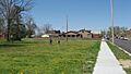
Union Station School: A School for Change
The Union Station School has a particularly important history. It was a school specifically for black children until 1966, when schools in the area became integrated (meaning students of all races could attend together). This building represents a significant time in the fight for equal rights.
- Address: 3138 Flagman Dr., Paducah
- Listed: August 19, 2011
Historic Districts: Entire Neighborhoods with History
Sometimes, it's not just one building that's historic, but an entire area or neighborhood. These are called "historic districts."
Jefferson Street-Fountain Avenue Residential District
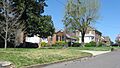
This district includes several streets and avenues, showing how homes and neighborhoods developed over time in Paducah. It's like a snapshot of how people lived in the past.
- Address: Jefferson and Madison Sts., Broadway, Fountain Ave., and Harahan Boulevard, Paducah
- Listed: July 14, 1982
Lower Town Neighborhood District
The Lower Town Neighborhood District is another important area. It's roughly bounded by Park Avenue and Jefferson, 5th, and 9th Streets. Walking through this district is like stepping back in time.
- Address: Roughly bounded by Park Ave. and Jefferson, 5th, and 9th Sts., Paducah
- Listed: March 15, 1982
Paducah Downtown Commercial District
This district covers the heart of downtown Paducah, including many businesses and buildings that show the city's commercial history.
- Address: Roughly bounded by 7th, 1st, Clark, and Monroe Sts., Paducah
- Listed: April 20, 1982
Paducah Market House District
This district surrounds the historic Market House, showing the area that grew up around this important community center.
- Address: 2nd St. between Broadway and Kentucky Ave., Paducah
- Listed: April 3, 1978
Wallace Park Neighborhood Historic District
The Wallace Park Neighborhood Historic District is another residential area recognized for its historical character.
- Address: Roughly bounded by Buckner Ln., Maple Ave., Forest Circle, and Lone Oak Rd., Paducah
- Listed: February 22, 2012
Other Notable Historic Sites
Archaeological Site 15McN51: The Reed Site
This isn't a building, but an archaeological site! It's also known as the "Reed Site" and is located under the Interstate 24 bridge over the Ohio River. Archaeological sites are places where scientists study the remains of past human activity, like old tools or settlements.
- Address: Under the Interstate 24 bridge over the Ohio River, Paducah
- Listed: July 11, 1985
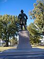
Confederate Monument in Paducah
Monuments are structures built to remember important people or events. This monument is located in Oak Grove Cemetery.
- Address: Oak Grove Cemetery, west of the junction of Park Ave. and 13th St., Paducah
- Listed: July 17, 1997
Lloyd Tilghman Memorial
Another memorial, this one honors Lloyd Tilghman and is located in Lange Park.
- Address: Lange Park, Madison St. between 16th and 19th Sts., Paducah
- Listed: July 17, 1997
Paducah Coca-Cola Bottling Plant
This building was once where Coca-Cola was bottled for the area. It's a cool piece of industrial history!
- Address: 3121 Broadway, Paducah
- Listed: July 30, 2013
Nashville, Chattanooga, and St. Louis Railway Office and Freight House
This building was part of the railway system, which was super important for transporting goods and people in the past.
- Address: 300 S. 3rd St., Paducah
- Listed: July 17, 1979
Shawnee Steam Plant
The Shawnee Steam Plant is a large industrial facility that generates electricity. It's recognized for its historical significance in power production.
- Address: 7900 Metropolis Lake Rd., West Paducah
- Listed: August 4, 2016
These are just some of the many fascinating places in McCracken County that are preserved because of their historical importance. Each one helps us understand the past and how the community has grown and changed over time.
Images for kids
-
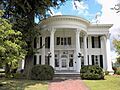
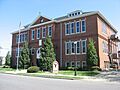
Artelia Anderson Hall
-
Anderson-Smith House (Whitehaven)
-
The Angles
-

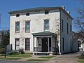
Archaeological Site 15McN51
-
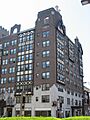
California Apartments
-
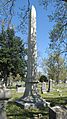
Confederate Monument in Paducah
-
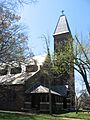
Grace Episcopal Church
-
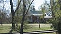
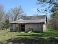
Home of the Friendless
-
Hotel Irvin Cobb
-
Hotel Metropolitan
-
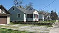
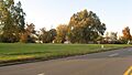
Jefferson Street-Fountain Avenue Residential District
-
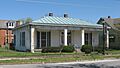
Kenmil Place
-
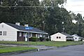
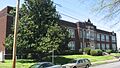
Lincoln School
-
Lower Town Neighborhood District
-
Market House
-
Masonic Temple
-
Nashville, Chattanooga, and St. Louis Railway Office and Freight House
-
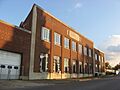
Paducah Coca-Cola Bottling Plant
-
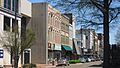
Paducah Downtown Commercial District
-
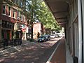
Paducah Market House District
-
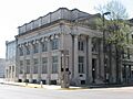
People's First National Bank and Trust Company Building
-
Saint Mary Academy Complex
-
St. Francis DeSales Roman Catholic Church
-
Augusta Tilghman High School
-
Lloyd Tilghman Memorial
-
Tilghman-Woolfolk House
-
Union Station School
-
Wallace Park Neighborhood Historic District
-
Mayor David A. Yeiser House


