
National Register of Historic Places listings in Missoula County, Montana facts for kids

Have you ever wondered about the old buildings and special places in your community? Many places have a rich history, and some are so important that they are listed on the National Register of Historic Places. This is a special list in the United States that helps protect and celebrate buildings, sites, and objects that have played a big part in history, architecture, or culture.
This article will tell you about some of the cool historic places in Missoula County, Montana. There are 88 places and areas in Missoula County on this list! Two of them are even more special, called National Historic Landmarks, which means they are important to the whole country. Let's explore some of these amazing spots!
Contents
Exploring Historic Places in Missoula County
Missoula County is full of interesting places that tell stories from the past. From old hotels to schools and even a Boy Scout camp, these sites help us understand what life was like long ago.
Historic Buildings in Missoula City
Missoula, the biggest city in the county, has many buildings on the National Register. These buildings often show different styles of architecture and how the city grew over time.
Old Hotels and Businesses
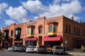
Many historic buildings in Missoula were once busy hotels or important businesses. These places were central to daily life.
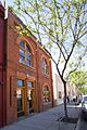
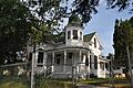
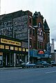
- Atlantic Hotel: Located at 519 N. Higgins Ave., this hotel was listed in 1990. It's a reminder of the early days when travelers and new residents came to Missoula.
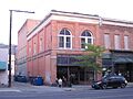
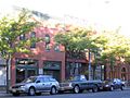
- Belmont Hotel: Found at 430 N. Higgins Ave., the Belmont Hotel was added to the list in 1983. Hotels like this were vital for people visiting or moving to the growing city.
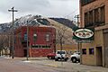
- Brunswick Hotel: At 223 Railroad St., this hotel was listed in 1990. Its location near the railroad would have made it a popular stop for train passengers.
- Florence Hotel: This grand building at 111 N. Higgins Ave. was listed in 1992. It was once a very fancy place to stay and a landmark in downtown Missoula.
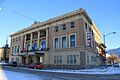
- Grand Pacific Hotel: Located at 118 W. Alder, this hotel joined the list in 1983. These old hotels often have unique designs and tell us about the city's early tourism.
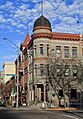
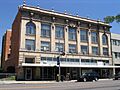
- Missoula Mercantile: At 114 N. Higgins Ave., this building was listed in 1990. It was a major department store, a bit like a shopping mall today, where people bought all sorts of goods.
- Montgomery Ward: Found at 201 N. Higgins Ave., this building was listed in 1990. Like the Mercantile, it was a big store where people shopped for many different things.


Important Public Buildings
Some buildings were built for public use, like libraries or government offices.
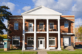
- Carnegie Public Library: At 335 N. Pattee St., this library was listed in 1982. It was built with money from Andrew Carnegie, who helped fund many libraries across the country. It was a place for learning and reading for everyone.
- Missoula County Courthouse: Located at 220 W. Broadway, this courthouse was listed in 1976. It's where important government decisions for the county are made. Courthouses often have impressive architecture.
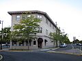
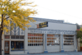
- U.S. Post Office: This building at 200 E. Broadway St. was listed in 1979. It was, and still is, a place where people send and receive mail, connecting Missoula to the rest of the world.
_-_Missoula_County,_Montana.png)


Churches and Schools
Places of worship and education are also important parts of a community's history.
- St. Francis Xavier Church: This beautiful church at 420 W. Pine St. was listed in 1982. Churches often show the artistic and spiritual history of a town.
- Lincoln School: At 1209 Lolo St., this school was listed in 1997. Old school buildings remind us of how education has changed over the years.
- Target Range Elementary School: Located at 4095 South Ave. W, this school was listed in 2011. It shows the growth of education in the Missoula area.

Other Notable Missoula Sites
Many other unique buildings and areas in Missoula are recognized for their historical value.
- Fort Missoula Historic District: Found at Reserve St. and South Ave., this area was listed in 1987. It was once a military fort and now tells the story of Missoula's past as a frontier town.
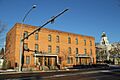
- Milwaukee Depot: At 250 Station Dr., this old train station was listed in 1982. Train depots were once bustling hubs where people traveled and goods were shipped.
- Wilma Theatre: This theater at 104 S. Higgins Ave. was listed in 1979. It's a historic place for entertainment, where people watched movies or live shows.
- Orange Street Underpass: This underpass at Orange St. between N. 2nd St. W. & W. Alder St. was listed in 2012. Even infrastructure like bridges and underpasses can be historically important!


Historic Sites Outside Missoula City
Missoula County also has important historic places beyond the city limits, often showing the rural and natural history of the area.
National Historic Landmarks
Two sites in Missoula County are so important they are called National Historic Landmarks.
- Lolo Trail: This historic trail, parallel to U.S. Route 12, was listed in 1966. It's a very old trail used by Native Americans and later by explorers like Lewis and Clark. It extends into Idaho.
- Traveler's Rest: Located about 1 mile south of Lolo near U.S. Route 93, this site was listed in 1966. It's famous as a campsite used by the Lewis and Clark Expedition.


Other County-Wide Sites
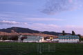
- Camp Paxson Boy Scout Camp: Near Seeley Lake, this camp was listed in 1986. It's a historic place where many young people have learned outdoor skills and made memories.
- Carlton Community Church: Located near Florence, this church was listed in 2011. It shows the history of small communities and their gathering places.
- DeSmet Schoolhouse: At 6105 Old Highway 10, W., this schoolhouse was listed in 1991. It's a glimpse into how education was provided in rural areas long ago.
- Double Arrow Lodge: Near Seeley Lake, this lodge was listed in 2014. It's a historic resort that has welcomed visitors to the beautiful Montana outdoors.
- Fort Fizzle Site: About 5 miles west of Lolo, this site was listed in 1977. It's a place with a unique name and a story from the Nez Perce War.
- Saint John the Baptist Catholic Church: In Frenchtown, this church on Mullan Rd. was listed in 1986. It's an important part of the history of the Frenchtown community.
- U.S. Forest Service Remount Depot: Southwest of Huson, this depot was listed in 1980. It was a place where horses were kept and trained for use by the Forest Service, important for exploring and managing the vast forests.


These are just some of the many fascinating historic places in Missoula County. Each one has a unique story that helps us understand the past and appreciate the heritage of Montana.
Images for kids
-
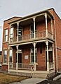
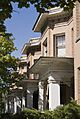
Apartment Building at 116 Spruce Street
-
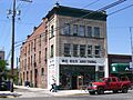
Atlantic Hotel
-

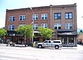
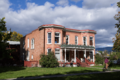
Bellows House
-
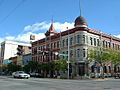
Belmont Hotel
-
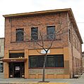
Bluebird Building
-
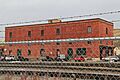
Brunswick Hotel
-

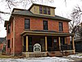
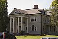
Thomas J. Christie House
-
Dixon-Duncan Block
-

East Pine Street Historic District
-

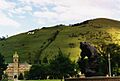
Flynn Ranch
-

Forkenbrock Funeral Home
-
Garden City Drug
-
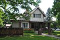
A.J. Gibson House
-
Gleim Building
-
Gleim Building II
-
Grand Pacific Hotel
-

Headquarters Building and Daily Company Annex
-
Hellgate Lodge 383 BPOE
-
J.M. Herzog House
-
Higgins Block
-
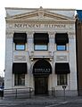
Independent Telephone Company Building
-

John S. Johnston House
-
John M. Keith House
-
Knowles Building
-
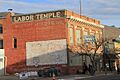
Labor Temple
-
Lenox Flats
-
Marsh and Powell Funeral Home
-
Masonic Lodge
-
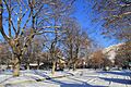
Missoula County Fairgrounds Historic District
-
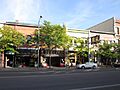
Missoula Downtown Historic District
-
Missoula Laundry Company
-
Missoula Mercantile Warehouse
-
Missoula Southside Historic District
-
Model Laundry and Apartments
-
Mrs. Lydia McCaffery's Furnished Rooms
-
Northern Pacific Railroad Depot
-
Northside Missoula Railroad Historic District
-
Palace Hotel
-
Edgar Paxson House
-
Clarence R. Prescott House
-
Reid House
-

Simons Block
-
Fred T. Sterling House
-
Studebaker Building
-
John R. Toole House
-
University Apartments
-
University Area Historic District
-
University of Montana Historic District
-
Zip Auto


.JPG)
_-_Missoula_County,_Montana.png)


.JPG)


_-_Missoula_County,_Montana.png)

_-_Missoula_County,_Montana.png)


_-_Missoula_County,_Montana.png)

_-_Missoula_County,_Montana.png)


_-_Missoula_County,_Montana.png)


_-_Missoula_County,_Montana.png)


_-_Missoula_County,_Montana.png)

_-_Missoula_County,_Montana.png)


_-_Missoula_County,_Montana.png)
