
National Register of Historic Places listings in Monroe County, Mississippi facts for kids

Monroe County, Mississippi, is home to many amazing places that are part of a special list called the National Register of Historic Places. This list helps protect buildings, sites, and districts that are important to the history of the United States. Think of it like a hall of fame for historic spots!
There are 36 different places in Monroe County on this list. One of them is even a National Historic Landmark, which means it's super important to the whole country's history. These places include old houses, downtown areas, and even ancient Native American sites.
Discovering Historic Places in Monroe County
Let's take a look at some of the cool historic places you can find in Monroe County, Mississippi. Each one has a story to tell about the past!
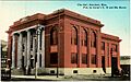
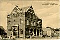
- Aberdeen City Hall
- Location: Aberdeen
- Listed: 1988
- This is the main building where the city's government works. It's an important part of Aberdeen's history.

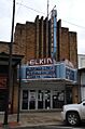
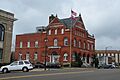
- Aberdeen Downtown Historic District
- Location: Aberdeen
- Listed: 1997
- This area includes many old buildings in the heart of Aberdeen. It shows what the town looked like long ago.

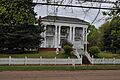
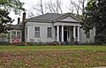
- Adams-French House
- Location: Aberdeen
- Listed: 1988
- This historic house is a great example of old architecture in Aberdeen.

- Baker Mound
- Location: Aberdeen area (address restricted)
- Listed: 1980
- This is an ancient mound, likely built by Native Americans long ago. Its exact location is kept secret to protect it.
- Building at 133 East Commerce Street
- Location: Aberdeen
- Listed: 1988
- This single building on East Commerce Street is recognized for its historical value.
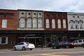
- Buildings at 110-122 East Commerce Street
- Location: Aberdeen
- Listed: 1988
- This group of buildings on East Commerce Street shows the history of the area.

- Buildings at NW Corner of Commerce and Meridian Streets
- Location: Aberdeen
- Listed: 1988
- These buildings at a busy intersection are also historically important.
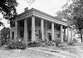
- Capt. Thomas Coopwood House
- Location: Aberdeen
- Listed: 2004
- This house belonged to Captain Thomas Coopwood, a notable person from the past.

- Cotton Gin Port Site
- Location: Amory area, along the Tombigbee River
- Listed: 1972
- This site was once a very important port where cotton was processed and shipped. It's a key part of the region's economic history.
- Crawford Site
- Location: Aberdeen area (address restricted)
- Listed: 1980
- Another protected archaeological site, likely holding clues about early human life in the area.
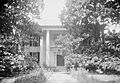
- Reuben Davis House
- Location: Aberdeen
- Listed: 1978
- This house was the home of Reuben Davis, a famous lawyer and politician from Mississippi.

- C.C. Day House
- Location: Aberdeen
- Listed: 1988
- The historic home of C.C. Day.
- William A. Dunklin House
- Location: Aberdeen
- Listed: 1988
- The historic home of William A. Dunklin.
- Harmon Subdivision Historic District
- Location: Aberdeen
- Listed: 1988
- This district includes a specific neighborhood with many historic homes.
- Hester-Standifer Creek Site
- Location: Amory area (address restricted)
- Listed: 1975
- This is a National Historic Landmark, meaning it's one of the most important archaeological sites in the entire country. Its location is kept secret to protect it.
- John Holliday House
- Location: Aberdeen
- Listed: 1988
- This house, also known as Holiday Haven, has a rich history.
.jpg)
- Inzer Site
- Location: Amory area (address restricted)
- Listed: 1973
- Another protected archaeological site near Amory.
- Johnson-Butler House
- Location: Aberdeen
- Listed: 1988
- A historic house in Aberdeen.
- Lawson Site
- Location: Amory area (address restricted)
- Listed: 1975
- This is another important archaeological site.
- Lenoir Plantation House
- Location: Prairie
- Listed: 1992
- This old plantation house gives us a glimpse into the agricultural history of the region.
- Mobile and Ohio Railroad Depot
- Location: Aberdeen
- Listed: 1983
- This old train station was a vital hub for transportation and trade.
- Monroe County Courthouse
- Location: Aberdeen
- Listed: 1978
- This beautiful building is where many important legal and government decisions have been made for Monroe County.

- Monroe County Jail
- Location: Athens
- Listed: 1978
- Also known as the Athens Jail, this historic building served as the county's jail.
- Mound Cemetery Site
- Location: Amory area (address restricted)
- Listed: 1975
- An ancient burial mound site, important for understanding early cultures.
- North Aberdeen Historic District
- Location: Aberdeen
- Listed: 1988
- This district covers a historic part of northern Aberdeen.
- Old Homestead
- Location: Aberdeen
- Listed: 1988
- This property is recognized as an "Old Homestead," meaning it's a very old and significant family home.
- Francis M. Rogers House
- Location: Aberdeen
- Listed: 1988
- The historic home of Francis M. Rogers.
- Sadler House
- Location: Aberdeen
- Listed: 2011
- A more recently listed historic house in Aberdeen.
- South Central Aberdeen Historic District
- Location: Aberdeen
- Listed: 1988 (with an expansion in 2004)
- This large district covers a significant historic area in south-central Aberdeen.
- James Young Thompson House
- Location: Amory
- Listed: 1990
- The historic home of James Young Thompson.
- U.S. Courthouse and Post Office
- Location: Aberdeen
- Listed: 1976
- This building served as both a courthouse and a post office, playing a key role in the community.

- US Post Office-Amory
- Location: Amory
- Listed: 1988
- The historic post office building in Amory.
- W.W. Watkins House
- Location: Aberdeen
- Listed: 1991
- The historic home of W.W. Watkins.
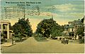
- West Commerce Street Historic District
- Location: Aberdeen
- Listed: 1988
- This district includes many historic buildings along West Commerce Street.

- Word Mound
- Location: Aberdeen area (address restricted)
- Listed: 1980
- Another ancient mound site, protected for its historical importance.
Images for kids
-
Aberdeen City Hall
-
Aberdeen Downtown Historic District
-
Adams-French House
-
Buildings at 110-122 East Commerce Street
-
Capt. Thomas Coopwood House
-
Reuben Davis House
-
John Holliday House
-
Monroe County Courthouse
-
U.S. Courthouse and Post Office
-
West Commerce Street Historic District
