
National Register of Historic Places listings in Oldham County, Kentucky facts for kids

This article is about the cool historic places in Oldham County, Kentucky that are listed on the National Register of Historic Places. This special list helps protect important buildings, sites, and objects across the United States. Think of it as a way to make sure these places last a long time for everyone to enjoy and learn from!
If a place is on the National Register, it means it's recognized as important to the history, architecture, archaeology, engineering, or culture of the nation. It's a big deal! In Oldham County, there are 48 different properties and areas that have made it onto this list.
Contents
What is the National Register of Historic Places?
The National Register of Historic Places is like a special club for old and important places in America. It's run by the National Park Service, which is part of the U.S. government. When a place gets listed, it means experts have decided it's worth saving because of its history or unique design.
Why are places listed?
Places are listed for many reasons. Maybe a famous person lived there, or an important event happened there. Sometimes, a building is a great example of a certain style of architecture, like a really old farmhouse or a fancy Victorian house. Listing these places helps us remember the past and understand how people lived a long time ago.
How does it help?
Being on the National Register doesn't mean the government owns the property, and it doesn't stop people from making changes to their own homes. However, it does offer some benefits. For example, owners might get special grants or tax breaks to help them fix up and preserve their historic properties. It also makes people more aware of the history around them!
Historic Places in Oldham County
Oldham County has many interesting places on the National Register. These include old farms, beautiful houses, and even entire neighborhoods that show how towns used to look. Let's look at a few examples of the kinds of places you might find:
Historic Homes and Farms
Many of the listings in Oldham County are old homes and farms. These places tell stories about the families who lived there and how farming shaped the area.
- Ashbourne Farms: This large farm is a great example of a historic agricultural property. It shows how farms were set up and used in the past.
- The Hermitage: Located off U.S. Route 42 in Goshen, this is another historic home that has been preserved.
- Johnson's Landing House and Farm: This property in Goshen was added to the list in 2016, showing its continued importance.
Historic Districts
Sometimes, it's not just one building that's important, but a whole group of buildings or a neighborhood. These are called historic districts.
- Ashwood Avenue Historic District: This area in Pewee Valley is a collection of homes that together show the history and style of the neighborhood.
- Central La Grange Historic District: This district covers the main parts of La Grange, including streets like Washington, Main, and Jefferson. It gives us a peek into what the town looked like long ago.
- Russell Court: Another district in La Grange, this area includes streets like Madison and Chestnut, showing a specific part of the town's development.
Important Buildings and Sites
Oldham County also has other types of historic listings, including churches and cemeteries.
- Confederate Memorial in Pewee Valley: This memorial and the cemetery around it are important historical sites that tell a part of the region's story.
- St. Aloysius Church: This church in Pewee Valley is a beautiful example of historic religious architecture.
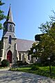
- Saint James' Episcopal Church: Also in Pewee Valley, this church is another significant historic building.
These are just a few examples of the many special places in Oldham County that are recognized for their historical value. Each one helps us understand the rich past of this part of Kentucky.
Images for kids
-
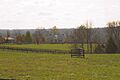
Ashbourne Farms
-
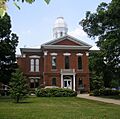
Oldham County Courthouse, part of the Central Avenue Historic District and Central La Grange Historic District
-
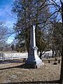
Confederate Memorial in Pewee Valley
-
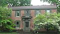
D. W. Griffith House
-
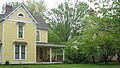
McMahan House in La Grange
-
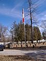
Pewee Valley Confederate Cemetery
-
Maple Avenue in Russell Court
-
St. Aloysius Church
-
Saint James' Episcopal Church


