
National Register of Historic Places listings in Park County, Colorado facts for kids

Welcome to Park County, Colorado! This beautiful area is home to many important places that tell us about the past. These special spots are listed on the National Register of Historic Places. This is a list kept by the United States government to recognize buildings, sites, and objects that are important in American history, architecture, archaeology, engineering, or culture.
When a place is on this list, it means it's considered very special and worth protecting for future generations. In Park County, there are 27 different places and areas that have earned this honor. Let's explore some of them and learn about their stories!
Contents
Historic Places in Park County
Fairplay's Fascinating History
Fairplay is the county seat of Park County, and it has many historic buildings. It's like a living museum!
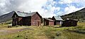
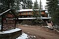
South Park City Museum

The South Park City Museum is a really cool place! It's an outdoor museum that shows what a mining town in Colorado looked like during the 1800s. You can walk around and see many old buildings that were moved here from other parts of Park County. It's a great way to imagine life long ago.
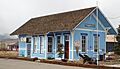
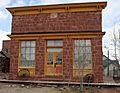
Fairplay Hotel

The Fairplay Hotel is a grand old building on Main Street. Hotels like this were very important in the past, offering a place for travelers and miners to stay. It's a reminder of the busy times when Fairplay was a growing town.
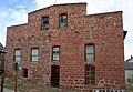
Park County Courthouse and Jail

The Park County Courthouse and Jail is another important building in Fairplay. Courthouses are where local government happens and laws are made and enforced. This building has seen a lot of history since it was built.
South Park Community Church

The South Park Community Church is a beautiful old church in Fairplay. Churches were often the center of community life, where people gathered for services and social events.
South Park Lager Beer Brewery

Even breweries have a place in history! The South Park Lager Beer Brewery building shows us how people made drinks in the past. It's part of the story of daily life and businesses in early Fairplay.
Summer Saloon

The Summer Saloon is another historic building that tells us about the social life of early Fairplay. Saloons were popular gathering spots where people would relax and socialize after a long day of work.
Como's Railroad Past
The town of Como was once a very important railroad hub. Many of its historic places are connected to trains.
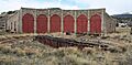
Como Roundhouse, Railroad Depot and Hotel Complex

The Como Roundhouse, Railroad Depot and Hotel Complex is a big part of Como's history. A roundhouse is a building where trains were stored and repaired. The depot was where passengers boarded and got off trains, and the hotel provided a place for them to stay. This complex was vital for the Denver, South Park and Pacific Railroad.
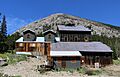
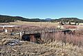
Boreas Railroad Station Site

High up on Boreas Pass, the Boreas Railroad Station Site marks where a busy train station once stood. This was a challenging part of the railroad line, especially in winter, and the station was a key stop for trains crossing the mountains.
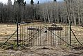
Como Cemetery

The Como Cemetery is a historic burial ground near Como. Cemeteries often hold the stories of the people who lived and worked in a town, giving us clues about its past residents.
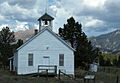
Como School

The Como School building reminds us of how children learned in the past. Schools were, and still are, important community centers where young people gain knowledge and skills.
Hartsel's Ranching and Salt History
Hartsel and its surrounding areas have a rich history of ranching and even salt production!
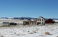
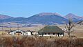
Buckley Ranch

The Buckley Ranch is a historic ranch property. Ranches were essential for raising livestock and providing food for the growing population of Colorado. They played a big role in the state's economy.
Colorado Salt Works
The Colorado Salt Works is a unique historic site. Imagine finding salt in the middle of Colorado! This place was important for producing salt, which was a valuable resource in the past for preserving food and other uses.
EM Ranch
The EM Ranch is another historic ranch in the Hartsel area. These ranches often have old buildings and landscapes that show how people lived and worked on the land many years ago.
Salt Works Ranch
The Salt Works Ranch is also connected to the historic salt production in the area. It's interesting how different parts of the land were used for various purposes, from ranching to mining for salt.
Threemile Gulch
Threemile Gulch is a historic area north of Hartsel. Many gulches and valleys in Colorado hold secrets of the past, from mining activities to early settlements.
Other Notable Historic Places
Glenisle

Located near Bailey, Glenisle is a historic property that has been recognized for its importance. Many old homes and estates have unique stories and architectural styles that reflect the time they were built.
Guiraud-McDowell Ranch

The Guiraud-McDowell Ranch near Garo is another historic ranch. These ranches often have a long family history and show how farming and ranching shaped the landscape and communities.
Jefferson Denver South Park and Pacific Railroad Depot

Just like Como, Jefferson also had an important railroad depot. The Jefferson Denver South Park and Pacific Railroad Depot was a key stop for trains, connecting communities and helping transport goods and people across the state.
Paris Mill

The Paris Mill near Alma is a historic mining mill. Mills like this were used to process ore extracted from mines, separating valuable metals like gold and silver. They were crucial to Colorado's mining boom.
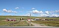
Shawnee Historic District

The Shawnee Historic District includes several historic buildings and areas in the town of Shawnee. Historic districts help preserve the overall look and feel of a place as it was in the past.
South Platte River Bridge

The South Platte River Bridge near Lake George is a historic bridge. Bridges are important structures that connect places and allow for travel and trade. Old bridges often show amazing engineering from their time.
Staunton Ranch-Rural Historic Landscape
The Staunton Ranch-Rural Historic Landscape is a large area that includes historic ranch buildings and the natural landscape around them. It shows how people lived and worked on the land, and how the land itself was used. This area also extends into Jefferson County.
Tarryall Rural Historic District
The Tarryall Rural Historic District is another large historic area, this time near Jefferson. It includes a wide stretch of land and properties that tell the story of rural life in Park County.
Tarryall School

The Tarryall School is a historic school building. These small, often one-room, schoolhouses were where many children in rural areas got their education in the past.
Trout Creek-Annex-Settele Ranch
The Trout Creek-Annex-Settele Ranch is another historic ranch property near Fairplay. Ranches like this are important for understanding the agricultural history of the region.
Wahl Ranch

The Wahl Ranch near Jefferson is also on the National Register. These historic ranches are often still working farms or have been preserved to show what life was like for early settlers and ranchers.
These historic places in Park County help us understand the rich history of Colorado, from its mining days and railroad boom to its ranching traditions and community life. They are treasures that connect us to the past!
Images for kids
-
The site of the old Boreas Railroad Station.
-
The Buckley Ranch.
-
The quiet Como Cemetery.
-
The renovated Como Roundhouse.
-
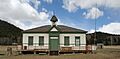
The historic Como School.
-
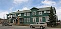
The historic Fairplay Hotel.
-
The historic Glenisle property.
-
The Guiraud-McDowell Ranch.
-
The Jefferson Denver South Park and Pacific Railroad Depot.
-
The historic Paris Mill.
-
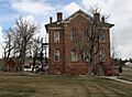
The old Park County Courthouse and Jail.
-
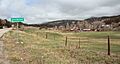
A view of Shawnee, Colorado.
-
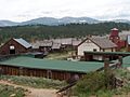
Step back in time at the South Park City Museum.
-
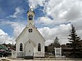
The charming South Park Community Church.
-
The historic South Park Lager Beer Brewery building.
-
The historic South Platte River Bridge.
-
The old Summer Saloon.
-
The old Tarryall Schoolhouse.
-
The Wahl Ranch.
